Brown Bluff
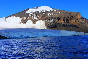
Brown Bluff is a tuya located at the northern tip of the Antarctic Peninsula, Antarctica. It formed in the past 1 million years, which erupted subglacially within an englacial lake. The volcano's original diameter is thought to have been about 12-15 kilometers, and probably formed by a single vent. Brown Bluff is subdivided into four stages: pillow volcano, tuff cone, slope failure, and hyaloclastite delta and into five structural units.[1]
The volcano is named "Brown Bluff" because of its steep slopes and its brown-to-black hyaloclastite.
Environment
Topography
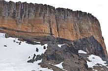
Brown Bluff has a 1.5 km long cobble and ash beach rising increasingly steeply towards towering red-brown tuff cliffs which are embedded with volcanic bombs. The cliffs are heavily eroded, resulting in loose scree and rock falls on higher slopes, and large, wind eroded boulders on the beach. Permanent ice and tidewater glaciers surround the site to the north and south, occasionally filling the beach with brash ice.
Flora and fauna
Lichens in the genera Xanthoria and Caloplaca have been recorded on exposed boulders from the shoreline to an elevation of 185 m. Mosses occur at higher elevations near glacial drainage.
The site has been identified as an Important Bird Area (IBA) by BirdLife International because it supports a breeding colony of about 20,000 pairs of adelle , as well as about 550 pairs of gentoos. Other birds nesting there include Cape petrels, Wilson's storm petrels and kelp gulls.[2] Weddell seals regularly haul out and leopard seals often hunt offshore.
See also
References
- ↑ Springerlink: Evolution of an englacial volcano: Brown Bluff, Antarctica. Retrieved on 2007-11-11
- ↑ "Brown Bluff". BirdLife data zone: Important Bird Areas. BirdLife International. 2012. Retrieved 2012-12-10.
- "Antarctic Treaty Visitor Guidelines, Brown Bluff" (PDF). Retrieved 2011-03-13.
Coordinates: 63°32′S 56°54′W / 63.533°S 56.900°W