Brovello-Carpugnino
| Brovello-Carpugnino | ||
|---|---|---|
| Comune | ||
| Comune di Brovello-Carpugnino | ||
| ||
 Brovello-Carpugnino Location of Brovello-Carpugnino in Italy | ||
| Coordinates: 45°49′N 8°27′E / 45.817°N 8.450°ECoordinates: 45°49′N 8°27′E / 45.817°N 8.450°E | ||
| Country | Italy | |
| Region | Piedmont | |
| Province | Province of Verbano-Cusio-Ossola (VB) | |
| Area | ||
| • Total | 8.3 km2 (3.2 sq mi) | |
| Elevation | 445 m (1,460 ft) | |
| Population (Dec. 2004) | ||
| • Total | 607 | |
| • Density | 73/km2 (190/sq mi) | |
| Demonym | Brovellesi | |
| Time zone | CET (UTC+1) | |
| • Summer (DST) | CEST (UTC+2) | |
| Postal code | 28010 | |
| Dialing code | 0323 | |
| Website | Official website | |

Brovello-Carpugnino is a comune (municipality) in the Province of Verbano-Cusio-Ossola in the Italian region Piedmont, located about 100 kilometres (62 mi) northeast of Turin and about 14 kilometres (9 mi) southwest of Verbania. As of 31 December 2004, it had a population of 607 and an area of 8.3 square kilometres (3.2 sq mi).[1]
Brovello-Carpugnino borders the following municipalities: Armeno, Gignese, Lesa, Massino Visconti, Stresa.
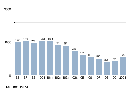
Demographic evolution
-

Saint Roch church
-

Carpugnino: Piazza I Gennaio
References
External links
| Wikimedia Commons has media related to Brovello-Carpugnino. |