Broomfleet
| Broomfleet | |
 Broomfleet |
|
| Population | 302 (2011 census)[1] |
|---|---|
| OS grid reference | SE881273 |
| – London | 155 mi (249 km) S |
| Civil parish | Broomfleet |
| Unitary authority | East Riding of Yorkshire |
| Ceremonial county | East Riding of Yorkshire |
| Region | Yorkshire and the Humber |
| Country | England |
| Sovereign state | United Kingdom |
| Post town | BROUGH |
| Postcode district | HU15 |
| Dialling code | 01430 |
| Police | Humberside |
| Fire | Humberside |
| Ambulance | Yorkshire |
| EU Parliament | Yorkshire and the Humber |
| UK Parliament | Haltemprice and Howden |
Coordinates: 53°44′05″N 0°39′52″W / 53.734688°N 0.664574°W
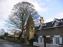
Broomfleet is a village and civil parish in the East Riding of Yorkshire, England. It is situated on the Humber estuary approximately 4 miles (6 km) west of Brough. According to the 2011 UK Census, Broomfleet parish had a population of 302,[1] an increase on the 2001 UK Census figure of 293.[2]

Broomfleet
The village is served by Broomfleet railway station on the Hull to York Line and the Hull to Sheffield Line.
Whitton Island in the Humber estuary falls partly within the parish. The island was formed from a mud and sand bank at the turn of the 21st century.[3][4]
References
- ↑ 1.0 1.1 "Key Figures for 2011 Census: Key Statistics: Area: Broomfleet CP (Parish)". Neighbourhood Statistics. Office for National Statistics. Retrieved 3 February 2013.
- ↑ "2001 Census: Key Statistics: Parish Headcounts: Area: Broomfleet CP (Parish)". Neighbourhood Statistics. Office for National Statistics. Retrieved 15 May 2008.
- ↑ "BBC Inside Out discovers an island paradise in the Humber" (Press release). BBC. 10 October 2002. Retrieved 20 November 2014.
- ↑ Ordnance Survey 1:25,000 scale Explorer mapping. Retrieved 31 October 2014
- Gazetteer — A–Z of Towns Villages and Hamlets. East Riding of Yorkshire Council. 2006. p. 4.
| Wikimedia Commons has media related to Broomfleet. |
| ||||||||||||||||||||||||||