Bromelton, Queensland
| Bromelton Queensland | |
|---|---|
|
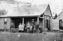
Moloney family, ~1897 | |
 Bromelton | |
| Coordinates | 27°59′S 152°56′E / 27.983°S 152.933°ECoordinates: 27°59′S 152°56′E / 27.983°S 152.933°E |
| Population | 307 (2011 census)[1] |
| Postcode(s) | 4285 |
| Location |
|
| LGA(s) | Scenic Rim Region |
| State electorate(s) | Beaudesert |
| Federal Division(s) | Forde |
Bromelton is a rural locality in the local government area of Scenic Rim Region in southern Queensland, Australia.[2] At the 2011 census, Bromelton and the surrounding area had a population of 307.[1]
History
Bromelton Post Office opened on 1 July 1927 (a receiving office had been open by 1883) and closed in 1938.[3]
Transport
The town has a crossing loop on the national standard gauge railway network. Because land is available at this site, it is proposed to construct a transport hub, where freight trains can be unloaded, or transshipped from standard gauge to narrow gauge. It is also the case the existing hub at Acacia Ridge is full and the owners of that hub are not prepared to make space available for other users.
The line between Acacia Ridge and Bromelton would be converted to dual gauge.
Bromelton station was served by a northbound XPT service to Roma Street and a southbound service to Sydney until it closed in 1994.[4]
Notable people
- Thomas de Montmorency Murray-Prior, born in Bromelton, Member of the Queensland Legislative Assembly
See also
References
- ↑ 1.0 1.1 Australian Bureau of Statistics (25 October 2007). "Bromelton (Beaudesert Shire) (State Suburb)". 2006 Census QuickStats. Retrieved 2009-07-25.
- ↑ "Bromelton (entry 46150)". Queensland Place Names. Queensland Government. Retrieved 14 February 2014.
- ↑ Premier Postal History. "Post Office List". Premier Postal Auctions. Retrieved 10 May 2014.
- ↑ "Bromelton Closure" Railway Digest April 1995 page 8
External links
![]() Media related to Bromelton, Queensland at Wikimedia Commons
Media related to Bromelton, Queensland at Wikimedia Commons