Brockley, Suffolk
| Brockley | |
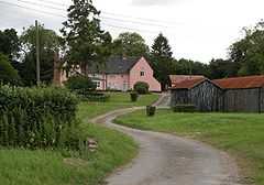 Grade I listed Brockley Hall |
|
 Brockley |
|
| Population | 281 (2001 census) |
|---|---|
| OS grid reference | TL8254 |
| Shire county | Suffolk |
| Region | East |
| Country | England |
| Sovereign state | United Kingdom |
| Post town | Bury St Edmunds |
| Postcode district | IP29 |
| Dialling code | 01 |
| EU Parliament | East of England |
Coordinates: 52°09′35″N 0°40′06″E / 52.1596°N 0.6682°E
Brockley (also known as Brockley Green) is a civil parish in the St Edmundsbury borough of Suffolk, England. According to the 2001 census it had a population of 281.
It is situated approximately 7 miles (11 km) south of Bury St Edmunds and 9 miles (14 km) north of Sudbury on the B1066. Also it is 2 miles (3 km) north of Hartest. A small hamlet, recorded in Domesday as "Brochola" or "Broclega": the name originates from 'woodland clearing by a brook'.
Mill Road marks the location of a former post mill which was demolished in 1930. East of B1066 is Willow Tree Farm (now Britton's Farm) (farthest out) with a small chapel (halfway to B1066). West of B1066 is Mile Farm (now Long's Farm) with the Pumping Station farthest west.
Brockley Hall and St Andrew's church are still around 1 km north of the village. St Andrew's dates from mediaeval times but was renovated in 1866. It is a grade II* listed building.[1]
There have been no public houses in the village since the 1980s, although prior to that there had been two: the Fox and Hounds and the The Six Bells.
A blacksmith used to be next door to the pub. A shop, and petrol station closed some years ago.
Brockley Cricket Club started over 50 years ago and supports three league teams playing in local leagues, a midweek team and a youth programme. The village also supports an indoor bowls club that has enjoyed some success in the past.
References
- ↑ "Name: ST ANDREW'S CHURCH List entry Number: 1279218". English Heritage. Retrieved 16 April 2014.
External links
| Wikimedia Commons has media related to Brockley, Suffolk. |
- Brockley's Website
- St. Andrew's Church www.suffolkchurches.co.uk
- St Andrews Church Pictures
- Brockley Cricket Club Official Site
- Local pictures
- Suffolk CAMRA