Bridekirk

Coordinates: 54°41′20″N 3°22′08″W / 54.689°N 3.369°W
Bridekirk is a township and a parish in the Allerdale district in the county of Cumbria, England. It is around 3.2 kilometres (2 mi) north of the Derwent river and about the same distance from the nearest large town of Cockermouth just south of the river. Bridekirk is just outside the Lake District National Park (1 mile (1.6 km) by road) and is not far from the Maryport and Carlisle Railway.[1][2]
In addition to the township of Bridekirk itself, Bridekirk parish also contains six other townships including Papcastle, Little Broughton, Great Broughton, Ribton, Dovenby, and Tallentire.[3]
Demography
According to the United Kingdom Census 2001, the township of Bridekirk has a population of 636 and 246 households in total.[4]
There are 335 economically active people in Bridekirk (between the ages of 16 and 74) and 125 economically inactive people in the same age bracket.
There are two main categories of employment in Bridekirk:
- Extractive and manufacturing industries = 33.7% (113 people)
- Service industries = 66.5% (223 people)
Other categories of employment are:
- Managerial and professional occupations = 55.8% (187 people)
- Small employers/self employed = 22.3% (75 people)
- Lower supervisory and technical occupations = 6.5% (22 people)
- Unemployed = 2% (7 people)[5]
Etymology
Bridekirk is "the church of St.Bride" (St. Bridget). Kirkja is Old Norse for "church".[6]
History
The earliest meaasure of Bridekirk’s population is after the 1800 Census Act when the government of Great Britain wanted to find the overall population of England, Wales and Scotland.[7] The 1801 census found the total population to be 1400.[8] The first records of housing numbers were in 1831, when there were 424 houses in Bridekirk. From 1851 to 1881, there was a sharp decrease in the amount of housing, with over 500 in 1851 and only 26 houses in 1881.[9]

Bridekirk has had three major boundary changes in its history. The first was in 1887 when the town of Dovenby was added to the parish. The second and third changes were in 1934 when Bridekirk's boundaries were made smaller by two towns being excluded from Bridekirk parish.[10]
The reason for the appearance of a sudden decline in the total population from 1851 to 1881 is because the census area for Bridekirk changed from including other townships in the area to smaller civil parish sub-districts. Rather than the townships that were included under Bridekirk's parish, the recorded population for Bridekirk was just the township of Bridekirk.[11]
Employment
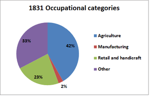
The pie chart on the right shows the earliest available information on the proportion of Bridekirk's workforce in each of four broad categories. The Agricultural bracket, being the largest group, included both large-scale and small-scale farmers and agricultural labourers. Retail and handicrafts included workers employed in small businesses producing and selling goods. The manufacturing category is small because the category mainly includes large-scale production and although 1831 was in the period of the industrial revolution, Bridekirk, being a small town, did not have a high number of factories or a large workforce for large-scale production.[13]
Bridekirk had a much larger production and agricultural sectors compared to today's employment in Bridekirk. However as shown above under the "Demography" section above, nowadays, around two thirds of the population work in the service sector, whereas in 1831 that was less than a third of the population, shown in the "other" category.
St. Bridget's Church
A wooden church had existed here since ancient times, but was replaced with a stone church in 1130.[14] Before the dissolution of the monasteries in the 16th century, St Bridget's Church was owned by the monastery of Guisborough.[15] Following the deterioration of the building over the years, a new church was built by the architects Corey and Ferguson in 1868 alongside the ruins of the chancel of the old church. Incorporated in the new church are several elements of the old church: the tympanum and archway of the south door, the door in the south transept, and the former chancel arch.[15] The new church is in neo-Norman style.[16][17]
Inside the church, the 12th-century font is possibly a remaining feature of the original church. For a Norman sculpture in the United Kingdom, it is in very good condition. The font was carved by Richard of Durham with the description, "Richard he me wrought, and to this beauty me brought." The font has runic decoration and portrays the story of Adam and Eve and also shows Christ's baptism.[16]
Outside the church, near the old chapel, there are a number of ancient tombstones and coffin lids.[16]
Governance
Bridekirk is part of the Workington constituency for UK parliament. The current Member of Parliament for the Workington constituency is Tony Cunningham, who is a member of the Labour Party.[18] The Labour Party has won the seat in the constituency in every general election since 1979. The Conservative Party has only been elected once in Workington since World War 2, at the 1976 election.[19]
Bridekirk Parish Council meets once a month in Bridekirk Dovenby School with the MP for Workington, the Cumbria County Councillor and the Allerdale Borough Councillors all elected representatives. However, the Parish Council has its own Councillors who usually attend the meetings.[20]
Transport
Within Bridekirk the only public transport is a bus service, which completes its route three times every weekday. The bus starts and stops the route in Cockermouth and stops in various other small towns in the area such as Papcastle and Tallentire and stops at the Dovenby School in Bridekirk.[21][22]
The nearest main road is the A595 which goes directly north-east to Carlisle, approximately 24.7 miles (39.8 km) from Bridekirk. For a public transport route, there is a bus route from Cockermouth to Maryport and then it takes approximately 45 minutes for the old Maryport and Carlisle Railway route to get from Maryport to Carlisle.[23][24]
Climate
| Climate data for Bridekirk, Cumbria, England | |||||||||||||
|---|---|---|---|---|---|---|---|---|---|---|---|---|---|
| Month | Jan | Feb | Mar | Apr | May | Jun | Jul | Aug | Sep | Oct | Nov | Dec | Year |
| Average high °C (°F) | 6 (43) |
7 (45) |
9 (48) |
11 (52) |
15 (59) |
17 (63) |
19 (66) |
19 (66) |
16 (61) |
13 (55) |
9 (48) |
7 (45) |
12.3 (54.3) |
| Average low °C (°F) | 2 (36) |
2 (36) |
3 (37) |
4 (39) |
6 (43) |
9 (48) |
12 (54) |
11 (52) |
9 (48) |
7 (45) |
4 (39) |
2 (36) |
5.9 (42.8) |
| Average precipitation cm (inches) | 9.39 (3.697) |
8 (3.1) |
7.33 (2.886) |
5.41 (2.13) |
5.62 (2.213) |
6.38 (2.512) |
6.14 (2.417) |
7.15 (2.815) |
8.32 (3.276) |
11.09 (4.366) |
9.85 (3.878) |
10.47 (4.122) |
95.15 (37.412) |
| Source: www.bing.com[25] | |||||||||||||
References
- ↑ "Bing map directions". Retrieved 2012-03-01.
- ↑ "Genuki website". Retrieved 2012-02-15.
- ↑ "A vision of Britain through time website". Retrieved 2012-02-15.
- ↑ "Office for National Statistics website". Retrieved 2012-02-17.
- ↑ "British Office for National Statistics website". Retrieved 2012-02-15.
- ↑ Armstrong, A. M.; Mawer, A.; Stenton, F. M.; Dickens, B. (1950). The place-names of Cumberland. English Place-Name Society, vol.xxi. Part 2. Cambridge: Cambridge University Press. p. 272.
- ↑ "British parliament website". Retrieved 2012-02-25.
- ↑ 8.0 8.1 "A vision of Britain website census data". Retrieved 2012-02-15.
- ↑ "A vision of Britain website census data". Retrieved 2012-03-05.
- ↑ "A vision of Britain - boundary changes". Retrieved 2012-04-27.
- ↑ "A vision of Britain census tables". Retrieved 2012-03-28.
- ↑ "A vision of Britain through time website". Retrieved 2012-04-25.
- ↑ "Vision of Britain website - industry statistics". Retrieved 2012-03-31.
- ↑ "Cumbria tourist website". Retrieved 2012-03-05.
- ↑ 15.0 15.1 "The Cumbria directory website". Retrieved 2012-04-26.
- ↑ 16.0 16.1 16.2 "Cumbria tourist website". Retrieved 2012-03-15.
- ↑ "British History Online website". Retrieved 2012-02-20.
- ↑ "Allerdale Borough Council website". Retrieved 2012-04-04.
- ↑ "A vision of Britain website - general elections section". Retrieved 2012-04-27.
- ↑ "Bridekirk parish website". Retrieved 2012-04-04.
- ↑ "Bridekirk parish council website". Retrieved 2012-04-01.
- ↑ "Cockermouth and Bridekirk bus timetable". Retrieved 2012-04-01.
- ↑ "Cockermouth bus routes website". Retrieved 2012-04-02.
- ↑ "Northern Railway Lines website". Retrieved 2012-04-02.
- ↑ "Weather in Bridekirk, Cockermouth". Retrieved 2012-04-13.
External links
- Cumbria County History Trust: Bridekirk (nb: provisional research only - see Talk page)