Brentford Ait
Brentford Ait is a long uninhabited ait (island) in the River Thames, with no buildings, on the Tideway near Brentford however administered by the London Borough of Richmond upon Thames in England.

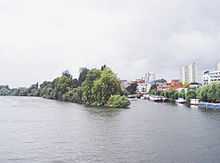
Brentford Ait has a gap in the middle known as Hog Hole which is apparent at higher tides. In the 18th century there was a notorious pub on Brentford Ait called the Swan or Three Swans — its trade was ended in 1796.[1] The Swan Steps lead down to the river at the east end of the long and narrow riverside park, Waterman's Park, at the site of the crossing to this pub. The ait was planted with trees in the 1920s to screen Brentford's gasworks from the view of Kew Gardens. The ait is covered by willows and alder and is a bird sanctuary with a significant heronry. For historic reasons unknown the parish of Kew in Surrey[2] included Brentford in its history; the London borough of Hounslow administer the neighbouring Lot's Island separated by thick, shifting mud at low tide from Brentford whereas channels on both sides of Brentford Ait are dredged.[3]
See also
References
- ↑ "Syon and Mortlake Reaches: PLA 307 & 308 Main Surveys (Extract)" (PDF). Port of London. Retrieved 2009-01-05.
- ↑ T F T Baker, C R Elrington (Editors), Diane K Bolton, Patricia E C Croot, M A Hicks (1982). "Ealing and Brentford: Introduction". A History of the County of Middlesex: Volume 7: Acton, Chiswick, Ealing and Brentford, West Twyford, Willesden. Institute of Historical Research. Retrieved 21 November 2012.
- ↑ Ordnance Survey map, courtesy of English Heritage
Bibliography
- Baker, T F T; Elrington, C R (editors); Bolton, Diane K; Croot, Patricia E C; Hicks, M A (1982). "Chiswick: Introduction". A History of the County of Middlesex: Volume 7: Acton, Chiswick, Ealing and Brentford, West Twyford, Willesden. Oxford: Oxford University Press for the University of London, Institute of Historical Research. pp. 50–51. OCLC 59178433. Retrieved 5 January 2009.
- Hatts, Leigh (2005). The Thames Path: From the Sea to the Source (2nd ed.). Milnthorpe: Cicerone. ISBN 978-1-85284-436-3. OCLC 276222230.
- Walker, Duncan. "Brentford Ait – Wild, Beautiful & Notorious". Brentford in Literature. Brentford Dock Right Now. Retrieved 26 August 2014.
| Next island upstream | River Thames | Next island downstream |
| Lot's Ait | Brentford Ait | Oliver's Island |
Coordinates: 51°29′11″N 0°17′39″W / 51.4863°N 0.2941°W