Bransat
| Bransat | ||
|---|---|---|
|
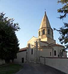
The church in Bransat | ||
| ||
 Bransat | ||
|
Location within Auvergne region  Bransat | ||
| Coordinates: 46°19′45″N 3°13′52″E / 46.3292°N 3.2311°ECoordinates: 46°19′45″N 3°13′52″E / 46.3292°N 3.2311°E | ||
| Country | France | |
| Region | Auvergne | |
| Department | Allier | |
| Arrondissement | Moulins | |
| Canton | Saint-Pourçain-sur-Sioule | |
| Intercommunality | Pays Saint-Pourcinois | |
| Government | ||
| • Mayor (2008–2014) | Maurice Boivin | |
| Area1 | 15.52 km2 (5.99 sq mi) | |
| Population (2008)2 | 513 | |
| • Density | 33/km2 (86/sq mi) | |
| INSEE/Postal code | 03038 / 03500 | |
| Elevation |
254–401 m (833–1,316 ft) (avg. 340 m or 1,120 ft) | |
|
1 French Land Register data, which excludes lakes, ponds, glaciers > 1 km² (0.386 sq mi or 247 acres) and river estuaries. 2 Population without double counting: residents of multiple communes (e.g., students and military personnel) only counted once. | ||
.svg.png)
Bransat is a commune in the Allier department in central France.
Population
| Historical population | ||
|---|---|---|
| Year | Pop. | ±% |
| 1962 | 521 | — |
| 1968 | 571 | +9.6% |
| 1975 | 532 | −6.8% |
| 1982 | 536 | +0.8% |
| 1990 | 484 | −9.7% |
| 1999 | 508 | +5.0% |
| 2008 | 513 | +1.0% |
See also
References
| Wikimedia Commons has media related to Bransat. |