Brandywell, Isle of Man
| Brandywell | |
|---|---|
|
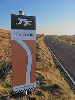
Brandywell Mountain Course Sign on A18 Snaefell Mountain Road looking south-west towards Hailwood Heights and Brandywell Corner. | |
| Coordinates | 54°14′34.2″N 4°28′10.2″W / 54.242833°N 4.469500°WCoordinates: 54°14′34.2″N 4°28′10.2″W / 54.242833°N 4.469500°W |
| Built | 1860–1870, 1935 |
 Location of Brandywell in Isle of Man | |
Brandywell, Isle of Man[1] (Manx: Chibbyr-y-Phunch or Chibbyr Slieau-ny-Maggle [2]), is situated between the 31st Milestone and 32nd Milestone racing road-side marker used for the Snaefell Mountain Course on the primary A18 Mountain Road with the road junction with the secondary B10 Brandywell Road in the parish of Kirk Michael in the Isle of Man.
Origin of Name
The name Brandywell originates from a nearby water-well that was used by local shepherds to brand and sort flocks of mountain sheep.[3] The area of Brandywell is open moorland situated in the Northern Uplands of the Isle of Man [4] and part of the common grazing land of Nobles Park which includes nearby Windy Corner and Keppel Gate. The footpath at Brandywell is an ancient ridge-way or pathway part of the Regiam Viam (Royal Way)[5] of the Kings of Mann and now part of the Isle of Man Millennium Way public footpath.[6]
A18 Snaefell Mountain Road
The A18 Snaefell Mountain Road was developed in the mid-nineteenth century from a number of pre-existing roads, carting-tracks and bridle paths. This included installation of a number of sheep-gates including the, Beinn-y-Phott sheep-gate and Nobles Park Gate at the Brandywell road junction.[7] This section of the A18 Snaefell Mountain Road from the Keppel Gate northwards to Park Mooar / Park Llewellyn (North Barrule) was built on common grazing land that were transferred to the UK Crown following the sale of the Islands feudal rights by the Duke of Atholl following a report made by the Disafforesting Commission of 1860.[8]
The area is dominated by the nearby Snaefell Mountain with an elevation of 621m (2036 feet) above sea level and the nearby summits of Beinn-y-Phott (544m), Mullagh Ouyr (491m) and Carraghan (500m). The Brandywell road junction has an Isle of Man TT Marshal communication shelter and a small Weather Station used by the Isle of Man Department of Infrastructure.[9]
Motor-sport heritage
The Brandywell[10] section of the A18 Snaefell Mountain Road was part of the 52.15 mile Highland Course (amended to 40.38 miles in 1906) and the 37.50 Mile Four Inch Course used for automobile racing including the 1904 Gordon Bennett Trial and the RAC Tourist Trophy car races held in the Isle of Man between 1905 and 1922. In 1911 the Four Inch Course for automobiles was first used by the Auto-Cycling Union for the Isle of Man TT motor-cycle races. This included the Brandywell Corner section and the course later became known as the 37.73 mile Snaefell Mountain Course and has been used since 1911 for the Isle of Man TT Races and from 1923 for the Manx Grand Prix.
The Brandywell Corner was subject to road widening with the removal of the Beinn-y-Phott sheep-gate on the A18 Mountain Road for the 1935 Isle of Man TT Races.[11]
The B10 Brandywell Road / C37 Druidale Road with its junction with the A18 Snaefell Mountain Road at Brandywell has been used as part of a special timed stage for the Rally Isle of Man and the former Manx International Rally.[12]
Mountain bikes
The Brandywell road junction forms part of two official mountain bike routes. The first A Grand Day Out (cross country loop) a mountain bike trail of 18.5 miles follows the B10 Brandywell Road and the A18 Snaefell Mountain Road and is classified as a Red difficult route.[13] The second official route is the St Luke's & Windy Corner (cross country loop) a mountain bike trail of 17 miles and is also classified as a Red difficult route.[14]
Gallery
-
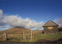
Brandywell Isle of Man TT Race Marshal Shelter and Weather Station on the A18 Mountain Road/B10 Brandywell Road looking north-east towards Snaefell Mountain and North Barrule.
-
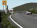
Sidecar combination at Brandywell during racing in 2005
Sources
- ↑ Manx Sun page 4 22nd September 1888 "Brandywell Junction" - Good Templar's Annual Picnic.
- ↑ Place Names of the Isle of Man by John Kneen MA page 435 (1970) Yn Cheshaght Ghailckagh The Scolar Press
- ↑ An Illustrated Encyclopaedia of the Isle of Man page 24 by David T.Webber Revised by Frank Cowin and F.J.Radcliffe;- Editor Gordon N. Kniveton (1997) The Manx Experience ISBN 1-873120-25-7 "The mountain road junction by Injebreck Hill, named after a well in the vicinity where shepherds used to gather for the sorting and branding of their mountain sheep."
- ↑ Manx Uplands and Steering Group – Issues and Opportunities page 4 & map page 13, (Scale 1:200,000) page 43, 53–54 (April 2014) Isle of Man Department for Environment, Food and Rural Affairs – Rheynn Chymmyltaght, Bee as Eirinys (DEFRA) – "Defining the Manx Uplands....all areas of ‘AML’ defined land(“Above the mountain line”, 250m above sea level), all land above 200m.... all areas of heathland, woodland and water catchment contiguous with the 200m contour."
- ↑ The Isle of Man by Train, Tram and by Foot page 118 by Stan Basnett (1990) Lily Publications ISBN 1-899602-72-0 Walk 22 - Millennium Way Ancient ridgeway Cronica - Regum Mannie et Insulaum
- ↑ The Isle of Man by Train, Tram and by Foot page 108 by Stan Basnett (1990) Lily Publications ISBN 1-899602-72-0 Walk 22 - Millennium Way
- ↑ Isle of Man Examiner page 4 9th December 1925 "MOTOR-CYCLE RELIABILITY RUN - The proposed course is via Anxfell, Laxey....Ramsey, Sulby, Tholty-y-Will, Bungalow and then to Nobles Gate and turn right to Brandywell over Injebreck Mountain...."
- ↑ Manx Milestones pages 13–17 and pages 57–58 by Stuart Slack (1st Edition)(2003)The Manx Experience ISBN 1-873120-58-3
- ↑ Isle of Man Examiner page 4 9th September 2008
- ↑ TT 100 The Official Authorised History of the Isle of Man Tourist Trophy Racing page 26 Mick Duckworth (2007) Lily Publications ISBN 1-899602-67-4 "....The wind can catch you out approaching Brandywell. It's as well to go in steady and take a classic racing line through...." The Mountain Course. A lap of the legendary circuit accompanied by the record holder John McGuinness.
- ↑ Isle of Man Weekly Times dated 25 May 1935
- ↑ "Public Notice - Manx International Rally 2004 ROADS CLOSED TO THE PUBLIC" B.W Hannay Director of Transport, Isle of Man Department of Transport (2004) Mannin Printing - Stage 17 Druidale, Brandywell. The C37 Druidale Road from its junction with the Ballaugh Glen Road to its junction to the B10 Brandywell Road at Brandywell Cottage. The Brandywell Road from its junction with the Druidale Road to its junction with the A18 Snaefell Mountain Road."
- ↑ Isle of Man Mountain Biking Guide – 8 complete self-guided routes page 3 Visit Isle of Man (2014) Isle of Man Department of Economic Development – "....Before you enter the open moorland, be sure to take a few minutes to soak up the magnificent view.... At the B10, turn left and follow this road through the cattle grid and on towards the TT Course. As you join the TT Course at Brandywell, you will see your starting point just half a mile to the north."
- ↑ Isle of Man Mountain Biking Guide – 8 complete self-guided routes page 6 Visit Isle of Man (2014) Isle of Man Department of Economic Development – ".... At the T junction turn right towards St Luke’s Church. At the church take the track on its right hand side and head north on this section of the Millennium Way. This is a long and steady climb that eventually brings you out on to the B10. Turn right and follow the B10 east towards the Mountain Road (TT Course)."
External links
| ||||||
| ||||||