Brand Highway
| Brand Highway Western Australia | |
|---|---|
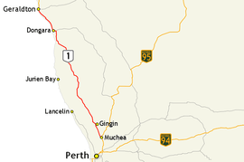 | |
| Map of Brand Highway, highlighted in red, and surrounding road network between Perth and Geraldton | |
| General information | |
| Type | Highway |
| Length | 367.98 km (229 mi)[1] |
| Opened | 4 April 1975 |
| Route number(s) |
|
| Major junctions | |
| South end |
|
| |
| North end |
|
| Location(s) | |
| Major settlements | Cataby, Badgingarra, Eneabba, Dongara |
| Highway system | |
|
Highways in Australia National Highway • Freeways in Australia Highways in Western Australia | |
Brand Highway is a 370-kilometre (230 mi) main highway linking the northern outskirts of Perth, the capital of Western Australia, to the port city of Geraldton in Western Australia's Mid West region. Together with North West Coastal Highway, it forms part of the Western Australian coastal link to the Northern Territory. The highway is a part of Australia's Highway 1, and is for the most part a single carriageway with one lane in each direction.[2]
The highway was completed in 1975 and opened in 1976 by then-Premier Charles Court, who named it in honour of former premier Sir David Brand. It replaced the old alignment from Dongara to Perth (Midlands Road).
Route description
Brand Highway begins in Muchea, branching off from Great Northern Highway along with National Route 1. The highway passes through agricultural areas, travelling through or near the towns of Gingin, Badgingarra (and Badgingarra National Park), Cataby, Eneabba, Dongara, and Greenough. The highway ends after 370 kilometres (230 mi) at the city of Geraldton. National Route 1, and traffic travelling to areas further north of here, continue along North West Coastal Highway towards Port Hedland. For the last 5 kilometres (3.1 mi) of its length, Brand Highway serves as the main road for the southern suburbs of Geraldton, including Wandina, Tarcoola Beach, Mount Tarcoola and Mahomets Flats.[2]
Main Roads Western Australia monitors traffic volume across the state's road network, including various locations along Brand Highway.[3]:3 In the 2012/13 financial year, the recorded traffic volumes ranged from 15,400 vehicles per day north of Olive Street, near Geraldton, down to 1470 south of Indian Ocean Drive. The highest percentage of heavy vehicles was 36.0% south of Airfield Road, the access road to RAAF Gingin.[3]:67, 90 Reports commissioned by the Royal Automobile Club of Western Australia (RAC) in 2006 and 2008 gave the highway a three-star safety rating out of five. The overall highway network was generally rated as three-star or four-star, with around 10% in 2006 and 5% in 2008 receiving a two-star rating.[4][5]
History
Brand Highway began as part of a network of roads between Dongara and Gingin, as a result of increased development in the area. Early surveying of the road, in the 1950s, was undertaken from within a light aircraft flying over the area. This was one of the first times in Western Australia that this technique was used. Wide road reserves, up to 200 metres (660 ft) in width, were acquired from crown land and pastoral leases. This allowed native wildflowers to survive and flourish on public land, providing aesthetically pleasing and interesting views to reduce road hypnosis and driver fatigue. The road would also be made safer by removing natural roadside obstacles, and replacing them with shrubs and more wildflowers.[6]:255–57
Construction on roads that would eventually be part of the Brand Highway began in 1959. Various segments were completed as the need arose, until in 1975, there was a new link between Perth and Geraldton. The route reduced the distance between the cities by 78 kilometres (48 mi), and had a total cost of $4.2 million. It was officially opened on 4 April 1975 by the Minister for Transport, Ray O'Connor at Eneabba.[6]:257 One year later, the road was named Brand Highway after Sir David Brand,[6]:257 who was Premier of Western Australia from 1959 to 1971 and also held the local electorate of Greenough from 1945 to 1975.[7] The change of name from Geraldton Highway to Brand Highway was gazetted on 12 March 1976.[8] Then-premier Charles Court officiated a ceremony held on 30 April 1976 at a tourist information bay in Dongoara,[6]:257–58 where a plaque was unveiled commemorating the naming of the highway.[7]
-
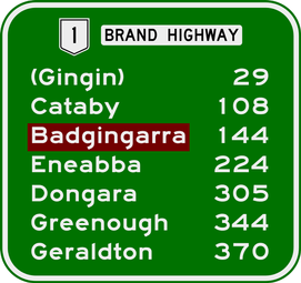
Distances to towns on or near the highway, from Muchea
-

View east near Moreton Terrace, Dongara
-
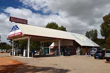
Badgingarra Roadhouse is located just off the highway
-
.JPG)
View south near Warradarge, 2014.
Major intersections
| LGA | Location | km[1] | mi | Destinations[9][10] | Notes |
|---|---|---|---|---|---|
| Chittering | Muchea | 0.00 | 0.00 | Southern terminus at traffic lights: continues east as Muchea East Road | |
| Gingin | Breera | 22.17 | 13.78 | Cockram Road – Gingin | |
| Granville | 31.47 | 19.55 | Gingin Brook Road – Yanchep, Lancelin | ||
| 31.92 | 19.83 | Dewar Road – Gingin, Bindoon | |||
| Red Gully | 74.43 | 46.25 | Mogumber Road West – Mogumber | ||
| 74.54 | 46.32 | Orange Springs Road – Ledge Point, Lancelin | |||
| Dandaragan | Regans Ford | 77.20 | 47.97 | Dandaragan Road – Dandaragan | |
| Mimegarra | 103.90 | 64.56 | Mimegarra Road west – Wedge Island | ||
| Cataby | 108.72 | 67.56 | Cataby Road – Dandaragan | ||
| Badgingarra | 138.91 | 86.31 | Bibby Road – Cervantes, Nambung National Park (The Pinnacles) | ||
| 151.64 | 94.22 | North West Road – Badgingarra, Moora | |||
| Boothendarra – Hill River boundary | 174.90 | 108.68 | Jurien Road – Jurien Bay | ||
| Coorow | Warradarge | 195.42– 195.66 | 121.43– 121.58 | Coorow–Green Head Road – Green Head, Leeman, Coorow | Staggered T junctions |
| Carnamah | Eneabba | 223.34 | 138.78 | Eneabba–Coolimba Road – Leeman | |
| 225.07 | 139.85 | Eneabba–Three Springs Road – Three Springs, Carnamah | |||
| Irwin | Arrowsmith | 273.73 | 170.09 | ||
| Yardarino | 290.78 | 180.68 | |||
| 297.34 | 184.76 | T junction: northbound traffic turns west, southbound traffic turns south | |||
| Dongara | 304.35 | 189.11 | |||
| 305.15 | 189.61 | Waldeck Street – Dongara, Port Denison | |||
| Greater Geraldton | Geraldton | 367.87– 367.98 | 228.58– 228.65 | Northern terminus at diamond interchange: continues north as Cathedral Avenue | |
| 1.000 mi = 1.609 km; 1.000 km = 0.621 mi | |||||
See also
External links
Route map: Bing
 Media related to Brand Highway at Wikimedia Commons
 Brand Highway travel guide from Wikivoyage
- Main Roads Western Australia
| ||||||||||||||||||||
| |||||||||||||||||||||||||||||
References
- ↑ 1.0 1.1 Main Roads Western Australia. "Road Information Mapping System". Government of Western Australia. Retrieved 23 April 2015.
- ↑ 2.0 2.1 Google (11 March 2013). "Brand Highway" (Map). Google Maps. Google. Retrieved 11 March 2013.
- ↑ 3.0 3.1 Main Roads Western Australia (2014). "Statewide Traffic Digest 2008/09 – 2013/14" (PDF). Government of Western Australia. Archived (PDF) from the original on 18 December 2014. Retrieved 7 April 2014. Additional archives: 7 April 2014.
- ↑ Roberts, Paul; Affum, Joseph; Taylor, Samantha (August 2006). "AusRAP Star Rating Maps and Road Protection Scores for Rural Western Australian Roads" (PDF). Royal Automobile Club of Western Australia. Archived (PDF) from the original on 7 April 2015. Retrieved 7 April 2015. Additional archives: 7 April 2015.
- ↑ "Safer Roads: Star Ratings for WA's Major Highways" (PDF). Royal Automobile Club of Western Australia. January 2008. Archived (PDF) from the original on 7 April 2015. Retrieved 7 April 2015. Additional archives: 7 April 2015.
- ↑ 6.0 6.1 6.2 6.3 Edmonds, Leigh (1997). The Vital Link: A History of Main Roads Western Australia 1926-1996. Nedlands, Western Australia: University of Western Australia Press. ISBN 1 876268 06 9.
- ↑ 7.0 7.1 Brand Highway (October 1976). Western Roads: official journal of the Main Roads Department, Western Australia, 1(4), p.9. Perth: Main Roads Department.
- ↑ "Change of Name of Streets (per Corres 1655/57, V2)" (PDF). Western Australia Government Gazette. 12 March 1976. p. 1976:738. Archived (PDF) from the original on 29 April 2015.
- ↑ Main Roads Western Australia (13 August 2013). Wheatbelt North Region map (PDF) (Map). Version 1.0. Government of Western Australia. Archived (PDF) from the original on 29 August 2013. Retrieved 20 December 2013. Additional archives: 27 December 2013.
- ↑ Main Roads Western Australia (16 August 2013). Mid West Region map (PDF) (Map). Version 1.0. Government of Western Australia. Archived (PDF) from the original on 29 August 2013. Retrieved 11 April 2015. Additional archives: 1 February 2014.