Brahmanbaria Sadar Upazila
| Brahmanbaria Sadar ব্রাহ্মণবাড়িয়া সদর | |
|---|---|
| Upazila | |
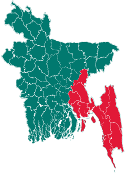
 Brahmanbaria Sadar Location in Bangladesh | |
| Coordinates: 23°57.2′N 91°7′E / 23.9533°N 91.117°ECoordinates: 23°57.2′N 91°7′E / 23.9533°N 91.117°E | |
| Country |
|
| Division | Chittagong Division |
| District | Brahmanbaria District |
| Area | |
| • Total | 495.85 km2 (191.45 sq mi) |
| Population (1991) | |
| • Total | 659,449 |
| • Density | 1,330/km2 (3,400/sq mi) |
| Time zone | BST (UTC+6) |
| Website | Official Map of Brahmanbaria Sadar |
Brahmanbaria Sadar (Bengali: ব্রাহ্মণবাড়িয়া সদর) is an Upazila of Brahmanbaria District in the Division of Chittagong, Bangladesh.
Geography
Brahmanbaria Sadar is located at 23°57′10″N 91°07′00″E / 23.9528°N 91.1167°E. It has 109,067 households and a total area of 495.85 km2 (191 sq mi).
Demographics
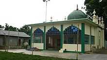
আনসার মুখতার মসজিদ, Ansar Mokhtar Mosque, an old mosque located at Medda of Brahmanbaria town
According to the 1991 Bangladesh census, Brahmanbaria Sadar had a population of 659,449. Males constituted 51.38% of the population, and females 48.62%. The population aged 18 or over was 312,696. Brahmanbaria Sadar had an average literacy rate of 30.1% (7+ years), against the national average of 32.4%.[1]
Administration
Brahmanbaria Sadar has 31 Unions/Wards, 379 Mauzas/Mahallas, and 398 villages. It has 1 municipality, that of Brahmanbaria town.
See also
References
- ↑ "Population Census Wing, BBS.". Archived from the original on 2005-03-27. Retrieved November 10, 2006.
| |||||||||||||||||||||||||||||||||||||||||||||||||||||