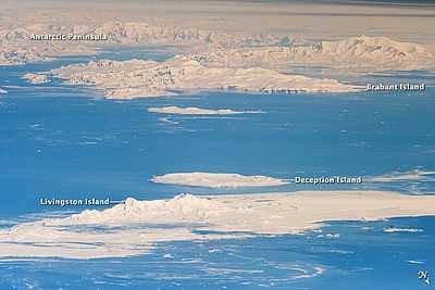
Brabant Island
 Location of Brabant Island | |
 Location in Antarctica | |
| Geography | |
|---|---|
| Location | Antarctica |
| Coordinates | 64°15′S 62°20′W / 64.250°S 62.333°WCoordinates: 64°15′S 62°20′W / 64.250°S 62.333°W |
| Archipelago | Palmer Archipelago |
| Length | 53 km (33 mi) |
| Width | 26 km (16 mi) |
| Highest elevation | 2,520 m (8,270 ft) |
| Highest point | Mount Parry |
| Country | |
|
None | |
| Demographics | |
| Population | Uninhabited |
| Additional information | |
| Administered under the Antarctic Treaty System | |
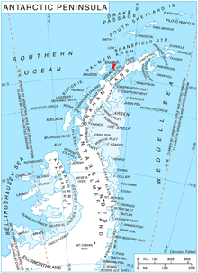
Brabant Island is the second largest island of the Palmer Archipelago within the British Antarctic Territory, lying between Anvers Island and Liège Island. Brabant Island is 53 km (33 mi) long north-south, 26 km (16 mi) wide, and rises to 2,520 m (8,268 ft) in Mount Parry. It was named by the Belgian Antarctic Expedition (1897-1899) under Adrien de Gerlache, who named it after the Belgian province of Brabant, in recognition of the support given to the expedition by its citizens.[1]
A paper summarizing the Joint Services expedition of 1984-1985 describes the island as "notoriously inhospitable" and states that there is evidence for only six visits between the discovery in 1898 and 1984.[2] Members of the expedition overwintered there in 1984-1985, and made the first ascent of Mount Parry.
See also
- Composite Antarctic Gazetteer
- List of Antarctic and sub-Antarctic islands
- List of Antarctic islands south of 60° S
- SCAR
- Territorial claims in Antarctica
References
- ↑ "Brabant Island". United States Gazetteer. Retrieved 2013-11-19.
- ↑ "Joint Services Expedition to Brabant Island, Antarctica, 1984/85". The Geographical Journal. Retrieved 2013-11-19.
External links
- Map of the area
- U.S. Geological Survey, Atlas of Antarctic Research
- (Portuguese) Brazilian Antarctic Program