Brønshøj-Husum
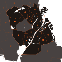
The districts of Copenhagen municipality:
A: Indre By ("Copenhagen Center")
B: Christianshavn
C: Indre Østerbro ("Inner Østerbro")
D: Ydre Østerbro ("Outer Østerbro")
E: Indre Nørrebro ("Inner Nørrebro")
F: Ydre Nørrebro ("Outer Nørrebro")
G: Bispebjerg
H: Vanløse
I: Brønshøj-Husum
J: Vesterbro
K: Kongens Enghave
L: Valby
M: Vestamager
N: Sundbyvester
O: Sundbyøster
Brønshøj-Husum is one of the 10 official districts of Copenhagen, Denmark.[1] It lies on the northwest border of the municipality. It covers an area of 8.73 km², has a population of 39,588.[2] The district, now a quiet suburban area, has developed around the two old villages of Brønshøj and Husum.
With 24.6% of the inhabitants having a non-Western background, Brønshøj-Husum is the most diverse district of Copenhagen.[3]
Neighboring city districts are as follows:
- to the east is Bispebjerg
- to the north is Gladsaxe and Herlev municipalities, which are outside of the Copenhagen municipality area
- to the west is Rødovre municipality, which is outside of the Copenhagen municipality area
- to the south is Vanløse
External links
References
- ↑ "Københavns bydele". Københavns Kommune. Retrieved 2009-11-02.
- ↑ "Folketal og boliger i bydele og roder samt folketal i skoledistrikter 1. januar 2009". København Kommune. Retrieved 2009-11-01.
- ↑ "Befolkningen efter herkomst og bydel 2012". Kk.dk. Retrieved 2012-09-29.