Boylston, Alabama
| Boylston | |
|---|---|
| Unincorporated community | |
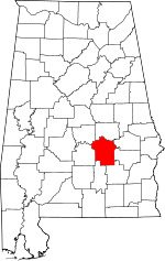
 Boylston Location within the state of Alabama | |
| Coordinates: 32°25′42″N 86°16′46″W / 32.42833°N 86.27944°WCoordinates: 32°25′42″N 86°16′46″W / 32.42833°N 86.27944°W | |
| Country | United States |
| State | Alabama |
| County | Montgomery |
| Elevation | 217 ft (66 m) |
| Time zone | Central (CST) (UTC-6) |
| • Summer (DST) | CDT (UTC-5) |
| Area code(s) | 334 |
| GNIS feature ID | 114799[1] |
Boylston, Alabama, is a populated place between the city of Montgomery, Alabama, and the Tallapoosa River. In 1950 it had a population of 1,000.
History
The community was likely named after a local family.[2] A post office opened under the name Boylston in 1827.[3]
References
- Encyclopædia Britannica Atlas, 1958 Edition, Plate 72.
- ↑ "Boylston". Geographic Names Information System. United States Geological Survey.
- ↑ Foscue, Virginia (1989). Place Names in Alabama. Tuscaloosa: The University of Alabama Press. p. 22. ISBN 0-8173-0410-X.
- ↑ "Montgomery County". Jim Forte Postal History. Retrieved 16 January 2015.
| |||||||||||||||||||||||||