Bowenville, Queensland
| Bowenville Queensland | |
|---|---|
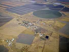
|
Bowenville looking southwards, May 2010. | |
 Bowenville | |
| Coordinates | 27°18′16″S 151°21′30″E / 27.30444°S 151.35833°ECoordinates: 27°18′16″S 151°21′30″E / 27.30444°S 151.35833°E |
| Population | 362 (2011 census)[1] |
| Established | 1890 (approx.) |
| Postcode(s) | 4404 |
| Location | |
| LGA(s) | Toowoomba Regional Council |
| State electorate(s) | Condamine |
| Federal Division(s) | Maranoa |
Bowenville is a town in the Toowoomba Regional Council local government area in Queensland, Australia. The town's economy rested on the rail industry and with the winding down of the railways the population declined. At the 2011 census, Bowenville had a population of 362.[1]
Just north of the Warrego Highway east of Dalby, Bowenville has the basic requirements for the traveller, including fuel, a post office, barbecues, a hotel and public telephone. It is a short drive from two major tourist attractions in the region, the historic Jondaryan Woolshed and the Acland Coal Mine.
History
Bowenville Post Office opened by June 1908 (a receiving office had been open from 1878).[2]
Facilities
Library services in Bowenville are provided by the Toowoomba Regional Council's mobile library service. The van visits Bowenville State School on the 2nd and 4th Tuesday of each month.[3]
Notes
- ↑ 1.0 1.1 Australian Bureau of Statistics (31 October 2012). "Bowenville (State Suburb)". 2011 Census QuickStats. Retrieved 1 July 2013.
- ↑ Premier Postal History. "Post Office List". Premier Postal Auctions. Retrieved 10 May 2014.
- ↑ "Mobile library". Toowoomba Regional Council. Retrieved 10 November 2014.
External links
![]() Media related to Bowenville, Queensland at Wikimedia Commons
Media related to Bowenville, Queensland at Wikimedia Commons
| ||||||||||||||||||