Bouzigues
| Bouzigues | ||
|---|---|---|
|
Shore of the Étang de Thau | ||
| ||
 Bouzigues | ||
|
Location within Languedoc-Roussillon region  Bouzigues | ||
| Coordinates: 43°26′57″N 3°39′32″E / 43.4492°N 3.6589°ECoordinates: 43°26′57″N 3°39′32″E / 43.4492°N 3.6589°E | ||
| Country | France | |
| Region | Languedoc-Roussillon | |
| Department | Hérault | |
| Arrondissement | Montpellier | |
| Canton | Mèze | |
| Intercommunality | Nord du Bassin de Thau | |
| Government | ||
| • Mayor (2014–2020) | Éliane Rosay | |
| Area1 | 3.05 km2 (1.18 sq mi) | |
| Population (2008)2 | 1,536 | |
| • Density | 500/km2 (1,300/sq mi) | |
| INSEE/Postal code | 34039 / 34140 | |
| Elevation |
0–61 m (0–200 ft) (avg. 5 m or 16 ft) | |
|
1 French Land Register data, which excludes lakes, ponds, glaciers > 1 km² (0.386 sq mi or 247 acres) and river estuaries. 2 Population without double counting: residents of multiple communes (e.g., students and military personnel) only counted once. | ||

.svg.png)
Bouzigues (Bosiga in Occitan) is a commune in the Hérault department in southern France.

Map
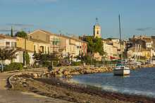
The village and the Étang de Thau
Population
| Historical population | ||
|---|---|---|
| Year | Pop. | ±% |
| 1962 | 767 | — |
| 1968 | 830 | +8.2% |
| 1975 | 904 | +8.9% |
| 1982 | 945 | +4.5% |
| 1990 | 907 | −4.0% |
| 1999 | 1,208 | +33.2% |
| 2008 | 1,536 | +27.2% |
See also
References
| Wikimedia Commons has media related to Bouzigues. |