Bouzanne
| Bouzanne | |
|---|---|
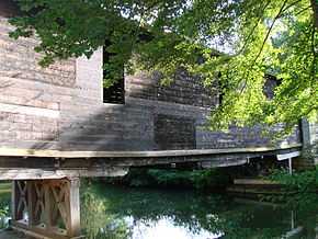 wooden covered bridge over the Bouzanne at Le Pont-Chrétien-Chabenet | |
| Origin |
in Aigurande 46°27′06″N 01°48′34″E / 46.45167°N 1.80944°E |
| Mouth |
Creuse 46°37′33″N 01°27′51″E / 46.62583°N 1.46417°ECoordinates: 46°37′33″N 01°27′51″E / 46.62583°N 1.46417°E |
| Basin countries | France |
| Length | 84.5 km (52.5 mi) |
| Source elevation | 385 m (1,263 ft) |
| Mouth elevation | 95 m (312 ft) |
| Avg. discharge | 3.23 m3/s (114 cu ft/s) at mouth |
| Basin area | 596 km2 (230 sq mi) |
The Bouzanne (French: la Bouzanne) is an 84.5 kilometres (52.5 mi) long river in the Indre département of central France, and is a tributary of the Creuse. Its source is in the commune of Aigurande, 2.5 kilometres (1.6 mi) northwest of the town itself, near the hamlet of la Bouzanne. It flows generally northwest, going northwards from its source up to Arthon, then southwest to the confluence where it enters the Creuse at the right-hand side of the flow (with forwards being downstream), 1.3 kilometres (0.81 mi) southwest of the village centre of Le Pont-Chrétien-Chabenet.
Communes along its course
The following list is ordered from source to mouth : Aigurande, La Buxerette, Montchevrier, Cluis, Mouhers, Neuvy-Saint-Sépulchre, Tranzault, Lys-Saint-Georges, Buxières-d'Aillac, Jeu-les-Bois, Arthon, Velles, Tendu, Mosnay, Saint-Marcel, Chasseneuil, Le Pont-Chrétien-Chabenet
Notes
- This article is based on the equivalent article from the French Wikipedia, consulted on January 30th 2009.
References
| Wikimedia Commons has media related to Bouzanne. |