Bouloc, Tarn-et-Garonne
| Bouloc | |
|---|---|
|
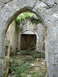
The remains of the chapel of Saint-Caprais, in Bouloc | |
 Bouloc | |
|
Location within Midi-Pyrénées region  Bouloc | |
| Coordinates: 44°18′01″N 1°07′38″E / 44.3003°N 1.1272°ECoordinates: 44°18′01″N 1°07′38″E / 44.3003°N 1.1272°E | |
| Country | France |
| Region | Midi-Pyrénées |
| Department | Tarn-et-Garonne |
| Arrondissement | Castelsarrasin |
| Canton | Lauzerte |
| Intercommunality | Quercy Pays de Serres |
| Government | |
| • Mayor (2008–2014) | Daniel Bonnemaison |
| Area1 | 14.81 km2 (5.72 sq mi) |
| Population (2006)2 | 215 |
| • Density | 15/km2 (38/sq mi) |
| INSEE/Postal code | 82021 / 82110 |
| Elevation |
116–265 m (381–869 ft) (avg. 240 m or 790 ft) |
|
1 French Land Register data, which excludes lakes, ponds, glaciers > 1 km² (0.386 sq mi or 247 acres) and river estuaries. 2 Population without double counting: residents of multiple communes (e.g., students and military personnel) only counted once. | |
Bouloc is a commune in the Tarn-et-Garonne department in the Midi-Pyrénées region in southern France.
Geography
The Séoune forms parts of the commune's western border. The Barguelonnette forms parts of the commune's southern border.
See also
References
| Wikimedia Commons has media related to Bouloc (Tarn-et-Garonne). |