Bosanska Otoka
| Bosanska Otoka | |
|---|---|
|
Bosanska Otoka with mosque at river Una | |
 Bosanska Otoka | |
| Coordinates: 44°57′36″N 16°10′45″E / 44.96000°N 16.17917°ECoordinates: 44°57′36″N 16°10′45″E / 44.96000°N 16.17917°E | |
| Country |
|
| Time zone | CET (UTC+1) |
| • Summer (DST) | CEST (UTC+2) |
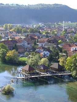
Bosanska Otoka or just Otoka is a town on the river Una in Bosnia and Herzegovina. It is part of the Bosanska Krupa municipality of the Una-Sana Canton of the Federation of Bosnia and Herzegovina.
The town was once known as Otok, the local word for island. It lies on the ancient Roman road from the Podunavlje-region to the Adriatic Sea
Otoka is located 11 km north of Bosanska Krupa, 23 km from Bužim and 22 km southwest of Novi Grad (former Bosanski Novi). Otoka is located on both banks of river Una and has 24 river isles and right and left bankside are connected with a steal bridge built up 1920.