Bortigali
| Bortigali | |
|---|---|
| Comune | |
| Comune di Bortigali | |
 | |
 Bortigali Location of Bortigali in Italy | |
| Coordinates: 40°17′N 8°50′E / 40.283°N 8.833°ECoordinates: 40°17′N 8°50′E / 40.283°N 8.833°E | |
| Country | Italy |
| Region | Sardinia |
| Province | Province of Nuoro (NU) |
| Frazioni | Mulargia |
| Area | |
| • Total | 67.4 km2 (26.0 sq mi) |
| Elevation | 510 m (1,670 ft) |
| Population (Dec. 2004) | |
| • Total | 1,502 |
| • Density | 22/km2 (58/sq mi) |
| Demonym | Bortigalesi |
| Time zone | CET (UTC+1) |
| • Summer (DST) | CEST (UTC+2) |
| Postal code | 08012 |
| Dialing code | 0785 |
Bortigali (Sardinian: Bortigale) is a comune (municipality) in the Province of Nuoro in the Italian region Sardinia, located about 120 kilometres (75 mi) north of Cagliari and about 45 kilometres (28 mi) west of Nuoro. As of 31 December 2004, it had a population of 1,502 and an area of 67.4 square kilometres (26.0 sq mi).[1]
The municipality of Bortigali contains the frazione (subdivision) Mulargia.
Bortigali borders the following municipalities: Birori, Bolotana, Dualchi, Macomer, Silanus.
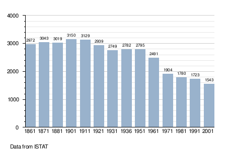
Demographic evolution
Climate
| Climate data for Bortigali | |||||||||||||
|---|---|---|---|---|---|---|---|---|---|---|---|---|---|
| Month | Jan | Feb | Mar | Apr | May | Jun | Jul | Aug | Sep | Oct | Nov | Dec | Year |
| Average high °C (°F) | 9 (48) |
10 (50) |
12 (53) |
15 (59) |
19 (66) |
24 (75) |
28 (82) |
28 (82) |
24 (75) |
19 (66) |
13 (55) |
10 (50) |
17.6 (63.4) |
| Average low °C (°F) | 3 (37) |
3 (37) |
5 (41) |
7 (44) |
10 (50) |
13 (55) |
16 (60) |
17 (62) |
14 (57) |
10 (50) |
7 (44) |
5 (41) |
9.2 (48.2) |
| Average precipitation mm (inches) | 99 (3.9) |
112 (4.4) |
81 (3.2) |
71 (2.8) |
38 (1.5) |
33 (1.3) |
5 (0.2) |
13 (0.5) |
41 (1.6) |
97 (3.8) |
130 (5.1) |
117 (4.6) |
837 (32.9) |
| Source: Weatherbase [2] | |||||||||||||
References
| Wikimedia Commons has media related to Bortigali. |
- ↑ All demographics and other statistics: Italian statistical institute Istat.
- ↑ "Weatherbase: Historical Weather for Bortigali, Italy". Weatherbase. 2011. Retrieved on November 24, 2011.