Borsele
| Borsele | |||
|---|---|---|---|
| Municipality | |||
|
Church in Ovezande | |||
| |||
.svg.png) Location in Zeeland | |||
| Coordinates: 51°26′N 3°49′E / 51.433°N 3.817°ECoordinates: 51°26′N 3°49′E / 51.433°N 3.817°E | |||
| Country | Netherlands | ||
| Province | Zeeland | ||
| Government[1] | |||
| • Body | Municipal council | ||
| • Mayor | Jaap Gelok (PvdA) | ||
| Area[2] | |||
| • Total | 194.52 km2 (75.10 sq mi) | ||
| • Land | 141.72 km2 (54.72 sq mi) | ||
| • Water | 52.80 km2 (20.39 sq mi) | ||
| Elevation[3] | 2 m (7 ft) | ||
| Population (May 2014)[4] | |||
| • Total | 22,651 | ||
| • Density | 160/km2 (400/sq mi) | ||
| Demonym | Borsselaar | ||
| Time zone | CET (UTC+1) | ||
| • Summer (DST) | CEST (UTC+2) | ||
| Postcode | 4430–4456 | ||
| Area code | 0113 | ||
| Website |
www | ||


Borsele (![]() pronunciation ; Zeelandic: Bossele) is a municipality in the southwestern Netherlands on Zuid-Beveland.
pronunciation ; Zeelandic: Bossele) is a municipality in the southwestern Netherlands on Zuid-Beveland.
The name of the municipality is spelled with a single s; the name of the eponymous village is Borssele, spelled with double s.
The municipality is mainly known for the Borssele Nuclear Power Station and the Central Storage For Radioactive Waste.
Population centres
Baarland, Borssele, Driewegen, Ellewoutsdijk, 's-Gravenpolder, 's-Heer Abtskerke, 's-Heerenhoek, Heinkenszand, Hoedekenskerke, Kwadendamme, Lewedorp, Nieuwdorp, Nisse, Oudelande and Ovezande.
Topography
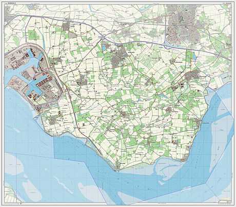
Dutch Topographic map of the municipality of Borsele, 2013.
Transport
The Western Scheldt Tunnel is from Ellewoutsdijk to Terneuzen in Zeeuws-Vlaanderen.
References
- ↑ "Samenstelling College van B&W" [Members of the board of mayor and aldermen] (in Dutch). Gemeente Borsele. Retrieved 6 December 2013.
- ↑ "Kerncijfers wijken en buurten" [Key figures for neighbourhoods]. CBS Statline (in Dutch). CBS. 2 July 2013. Retrieved 12 March 2014.
- ↑ "Postcodetool for 4441AT". Actueel Hoogtebestand Nederland (in Dutch). Het Waterschapshuis. Retrieved 6 December 2013.
- ↑ "Bevolkingsontwikkeling; regio per maand" [Population growth; regions per month]. CBS Statline (in Dutch). CBS. 26 June 2014. Retrieved 24 July 2014.
External links
 Media related to Borsele at Wikimedia Commons
- Official website
 |
Middelburg | Goes | Kapelle | |
| Vlissingen | |
|||
| ||||
| | ||||
| Western Scheldt Terneuzen |
| |||||||||||||
