Borough of Boston
| Borough of Boston | |
|---|---|
| Borough | |
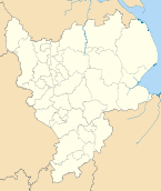
 Shown within the ceremonial county of Lincolnshire | |
| Sovereign state | United Kingdom |
| Constituent country | England |
| Region | East Midlands |
| Administrative county | Lincolnshire |
| Admin. HQ | Boston |
| Government | |
| • Type | Boston Borough Council |
| • Leadership: | Leader & Cabinet |
| • Executive: | Conservative |
| • MPs: | Mark Simmonds |
| Area | |
| • Total | 139.6 sq mi (361.5 km2) |
| Area rank | 116th |
| Population (2011 est.) | |
| • Total | 64,637 |
| • Rank | Ranked 306th |
| • Density | 460/sq mi (180/km2) |
| Time zone | Greenwich Mean Time (UTC+0) |
| • Summer (DST) | British Summer Time (UTC+1) |
| ONS code |
32UB (ONS) E07000136 (GSS) |
| Ethnicity | 98.4% White |
| Website | boston.gov.uk |
The Borough of Boston is a local government district with borough status in Lincolnshire, England. Its council is based in the town of Boston. It lies around N 53°0' W 0°0'.
Boston borough borders East Lindsey to the north, The Wash to the east, South Holland to the south, and North Kesteven to the west.
Post codes used in the district are: in Boston town, PE21 and elsewhere, PE20 and PE22.
History
The borough was formed on 1 April 1974 by the merger of the former borough of Boston with Boston Rural District.
Until 1974, Lincolnshire comprised three Parts, somewhat like the Ridings of Yorkshire. In Lincolnshire, "Parts" was the formal designation. They were the Parts of Lindsey, Kesteven and Holland. In their final form, they were each, in effect, an administrative county. The 1974 changes divided the Parts of Holland into two districts; the Borough of Boston is the northern one.
Management
- Summary of the Council's organization.
- Day to day management
- Key to descriptions of council services.
Political composition
The current political composition of the council is as follows:
| Party | Councillors | |
|---|---|---|
| Conservatives | 16 | |
| Independents | 4 | |
| Independent Group 2 | 4 | |
| Labour | 3 | |
| Lincolnshire Independents | 2 | |
| Unaligned | 2 | |
| English Democrats | 1 | |
The council is controlled by the Conservatives as of May 2011.[1]
Election results
For full election results see: Boston local elections.
Electoral arrangements
The Borough includes the town of Boston and 18 other, rural wards.
The town electoral wards
They are as follows:
- Central Ward elects one councillor.
- Fenside Ward elects two councillors 12.
- North Ward elects two councillors 12.
- Pilgrim Ward elects one councillor.
- Skirbeck Ward elects three councillors 123.
- South Ward elects one councillor.
- Staniland North Ward elects one councillor.
- Staniland South Ward elects two councillors 12.
- West Ward elects one councillor.
- Witham Ward elects two councillors 12.
The rural electoral wards
Each comprises one or more civil parishes:
- Coastal Ward elects two councillors 12.
- Fishtoft Ward elects three councillors 123.
- Five Village Ward elects two councillors 12.
- Frampton & Holme Ward elects one councillor.
- Kirton Ward elects two councillors 12.
- Old Leake & Wrangle Ward elects two councillors 12.
- Swineshead & Holland Fen Ward elects two councillors 12.
- Wyberton Fen Ward elects two councillors 12.
Demographics
In 2007, for all districts of Lincolnshire, Boston got the lowest GCSE results. It also has the least-educated group of people in Lincolnshire. At the 2001 census, there were 55,739 citizens in the district. The district has the highest Total Fertility Rate for district councils in England. Only the unitary authorities of Peterborough, Luton, Slough, Blackburn with Darwen. Newham, Barking with Dagenham, and Rutland (the highest) have larger TFRs. It has the same TFR as Oldham, a unitary authority.
References
- ↑ "How the council works". Boston Borough Council. 21 May 2013. Retrieved 30 May 2013.
| ||||||||||||||||||||||||||||
| ||||||||||||||||||||||