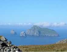
Boreray, St Kilda
| Location | |
|---|---|
 Boreray Boreray shown within the Outer Hebrides | |
| OS grid reference | NA153053 |
| Names | |
| Gaelic name | Boraraigh |
| Meaning of name | "Fort island", from Norse |
| Physical geography | |
| Island group | St Kilda |
| Area | 86 ha (0.33 sq mi)[1] |
| Area rank | 155= [2] |
| Highest elevation | Mullach an Eilein 384 m (1,260 ft) |
| Political geography | |
| Sovereign state | United Kingdom |
| Country | Scotland |
| Council area | Na h-Eileanan Siar |
| Demographics | |
| Population | 0 |
| Population rank | 0 [2] |
| References | [3][4][5][6] |
Boreray (Scottish Gaelic: Boraraigh, pronounced [pɔrˠarˠɤi]) is an uninhabited island in the St Kilda archipelago in the North Atlantic.
Geography
Boreray lies about 66 km (41 mi) west-north-west of North Uist. It covers about 77 hectares (0.30 sq mi), and reaches a height of 384 metres (1,260 ft) at Mullach an Eilein.

| Mullach an Eilein | |
|---|---|
| Elevation | 384 m (1,260 ft) |
| Prominence | 384 m (1,260 ft) |
| Listing | Marilyn |
| Translation | Top/upper part of the island (Scottish Gaelic) |
| Pronunciation | Scottish Gaelic: [ˈmul̪ˠəx ən̪ˠ ˈjeʎɛɲ] |
| Location | |
| Location | St Kilda, Scotland |
| OS grid | NA153053 |
| Coordinates | 57°52′11″N 08°29′26″W / 57.86972°N 8.49056°W |
| Topo map | OS Landranger 18 |
Boreray is formed of a breccia of gabbro and dolerites.[1]
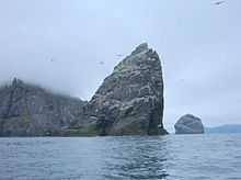
There are two sea stacks, vertical pillars of rock, just off Boreray. Stac An Armin, (¼ mi) to the north, is the taller at 196 metres (643 ft) high, while Stac Lee, 600 m (660 yards) to the west, is 172 metres (564 ft) high.
Boreray is the smallest of the Scottish islands to have a summit over one thousand feet.
History
Boreray has the Cleitean MacPhàidein, a "cleit village" of three small bothies used on a regular basis during fowling expeditions from Hirta.[7] As a result of a smallpox outbreak on Hirta in 1724, three men and eight boys were marooned on Boreray until the following May.[8]
There are also ruins of Taigh Stallar (the steward's house). The local tradition was that it was built by the "Man of the Rocks", who led a rebellion against the landlord's steward.[7] It may be an example of an Iron Age wheelhouse and the associated remains of an agricultural field system and two additional possible settlement mounds were discovered in 2011.[9][10][11] RCAHMS surveyor Ian Parker said:
“This new discovery shows that a farming community actually lived on Boreray, perhaps as long ago as the prehistoric period. The agricultural remains and settlement mounds give us a tantalising glimpse into the lives of those early inhabitants. Farming what is probably one of the most remote – and inhospitable – islands in the North Atlantic would have been a hard and gruelling existence. And given the island’s unfeasibly steep slopes, it’s amazing that they even tried living there in the first place.”[10]
Macauley (1764) reported the existence of five druidic altars in the islands including a large circle of stones fixed perpendicularly in the ground, by the Stallar House.[12]
The islands were bought in 1931 by the ornithologist John Crichton-Stuart, 5th Marquess of Bute. In 1957, following his death, they were bequeathed to the National Trust for Scotland (NTS), the current owner.[1]
St Kilda was inscribed by UNESCO as a World Heritage Site in 1986 in recognition of its Natural Heritage; for its exceptional natural beauty and for the significant natural habitats that it supports. In July 2004 this was extended to include the surrounding marine environment. In July 2005 further recognition for the islands cultural heritage was awarded making it one of only a few places in the world with Dual World Heritage Status for both its natural and cultural significance.[13]
Gallery
-

The island of Sgarbhstac and the rocky point of Gob Scapanais
-

Boreray from the south west
-

Cleitein McPhaidein, Boreray
-

Eastern Boreray
-

Steep crag on the east side of Boreray
-

Stac Lee
-

Pinnacle, Mullach an Eilean
-

A sea cave off Boreray
-

South slopes of Mullach an Eilean
-

Stac an Armin
-

The stacs Lee and an Armin
-

Stack Lee from above
-

Unnamed stack beneath Boreray
Wildlife
Boreray's cliffs are home for various seabirds. In 1959, 45,000 pairs of gannets were counted on the island and the two stacks. There are also over 130 different varieties of flowering plant on the island.[4] The island is also the home to an extremely rare breed of sheep, also called Boreray.
See also
Footnotes
- ↑ 1.0 1.1 1.2 "World Heritage Sites Protected Areas Programme - St Kilda" (PDF). United Nations Environment Programme. Retrieved 2008-01-05.
- ↑ 2.0 2.1 Area and population ranks: there are c. 300 islands >20ha in extent and 93 permanently inhabited islands were listed in the 2011 census.
- ↑ 2001 UK Census per List of islands of Scotland
- ↑ 4.0 4.1 Haswell-Smith (2004) pp. 323-36
- ↑ Ordnance Survey
- ↑ Iain Mac an Tailleir. "Placenames" (PDF). Pàrlamaid na h-Alba. Retrieved 2007-07-28.
- ↑ 7.0 7.1 Maclean (1977) page 28.
- ↑ Maclean (1977) pages 48–9
- ↑ Fleming (2005) page 58.
- ↑ 10.0 10.1 "Evidence of Ancient Settlement Found on Boreray". (16 June 2011) RCHAMS. Retrieved 19 June 2011.
- ↑ "Prehistoric finds on remote St Kilda's Boreray isle". (17 June 2011) BBC News. Retrieved 19 June 2011.
- ↑ Macauley, Rev Kenneth (1764) History of St Kilda. London
- ↑ "St Kilda". National Trust for Scotland. Retrieved 2008-01-05.
References
- Fleming, Andrew (2005) St. Kilda and the Wider World: Tales of an Iconic Island, Windgather Press ISBN 1-905119-00-3
- Haswell-Smith, Hamish (2004). The Scottish Islands. Edinburgh: Canongate. ISBN 1-84195-454-3.
- Maclean, Charles (1977) Island on the Edge of the World: the Story of St. Kilda, Edinburgh, Canongate ISBN 0-903937-41-7
Coordinates: 57°52′11″N 08°29′26″W / 57.86972°N 8.49056°W
| ||||||||||||||||||