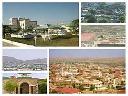
Borama
| Borama Boorama بوراما | |
|---|---|
| City | |
 | |
 Borama Location in Somalia | |
| Coordinates: 9°55′59″N 43°10′54″E / 9.93306°N 43.18167°ECoordinates: 9°55′59″N 43°10′54″E / 9.93306°N 43.18167°E | |
| Country |
|
| Region | Awdal |
| District | Borama |
| Government | |
| • Mayor | Suleiman Hassan Hadi |
| Population | |
| • Total | 215,616 |
| Time zone | EAT (UTC+3) |
| Climate | BSh |
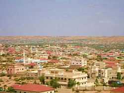
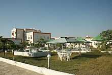
Borama (Somali: Boorama, Arabic: بوراما), also known as Borame, is the capital of the northwestern Awdal region of Somalia. The commercial seat of the province, it is situated near the border with Ethiopia.
During the Middle Ages, Borama was ruled by the Adal Sultanate. It later formed a part of the British Somaliland protectorate in the first half of the 20th century.
The city has a population of around 215,616 residents.[1] It has been a leading example in community organizing, having been the first area in northwestern Somalia to adopt a self-help scheme in the wake of the civil war.[2]
History
As with several nearby towns such as Amud, numerous archaeological finds have been discovered in the Borama area that point to an eventful past. The latter include ancient remains of tombs, houses and mosques, in addition to sherds of Oriental wares, particularly Chinese porcelain. The artefacts and structures date from various historical periods, ranging from the 12th through to the 18th centuries. Most, however, are from the 15th and 16th centuries, a time of great commercial activity in the region that is associated with the medieval Adal Sultanate.[3]
Excavations in the late 1800s and early 1900s at over fourteen sites in the vicinity of Borama unearthed, among other things, coins identified as having been derived from Kait Bey, the eighteenth Burji Mamluk Sultan of Egypt. Most of these finds were sent to the British Museum for preservation shortly after their discovery.[4]
In the first half of the 20th century, Borama formed a part of the British Somaliland protectorate. It was later given district status in 1925.
In 1933, Sheikh Abdurahman Sheikh Nuur, a Qur'anic teacher and son of Borama's qadi (judge), devised a new orthography for transcribing the Afro-Asiatic Somali language. A quite accurate phonetic writing system, this Borama script was principally used by Nuur and his circle of associates in the city.[5][6] The alphabet is also generally known as the Gadabuursi script.[7]
During the onset of World War II, the town was captured by the Italians. It was re-captured by the British the following year, in 1940. In the post-independence period, Borama was administered as part of the official Awdal administrative region of Somalia. During the Ogaden War in the late 1970s, Borama was one of several northern cities that was aerially bombarded by Ethiopian forces.[8]
Since the 2000s, control of the town has been disputed between Awdalland, a proposed autonomous state, and Somaliland, a self-declared republic that is internationally recognized as an autonomous region of Somalia.
Geography
Location and habitat
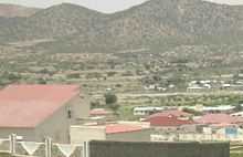
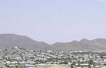
Borama is situated in northwestern Somalia, in a mountainous and hilly area. It has green meadows and fields, and represents a key focal point for wildlife. The town's unusual fertility and greenery in the largely arid countryside has attracted many fauna, such as gazelles, birds and camels.
Climate
The prevailing climate in Borama is known as a local steppe climate. The warmest month of the year is June with an average temperature of 24.1 °C. In January, the average temperature is 17.1 °C. It is the lowest average temperature of the whole year and the difference in precipitation between the driest month and the wettest month is 110 mm. The average temperatures vary during the year by 7 °C.[9]
| Climate data for Borama | |||||||||||||
|---|---|---|---|---|---|---|---|---|---|---|---|---|---|
| Month | Jan | Feb | Mar | Apr | May | Jun | Jul | Aug | Sep | Oct | Nov | Dec | Year |
| Average high °C (°F) | 24.6 (76.3) |
25.4 (77.7) |
27.5 (81.5) |
27.8 (82) |
29.3 (84.7) |
30.0 (86) |
28.8 (83.8) |
28.8 (83.8) |
29.0 (84.2) |
27.4 (81.3) |
25.8 (78.4) |
24.4 (75.9) |
27.4 (81.3) |
| Average low °C (°F) | 9.7 (49.5) |
11.7 (53.1) |
13.8 (56.8) |
15.7 (60.3) |
17.0 (62.6) |
18.3 (64.9) |
17.8 (64) |
17.6 (63.7) |
17.3 (63.1) |
13.7 (56.7) |
11.3 (52.3) |
10.4 (50.7) |
14.53 (58.14) |
| Average rainfall mm (inches) | 6 (0.24) |
21 (0.83) |
36 (1.42) |
86 (3.39) |
61 (2.4) |
32 (1.26) |
78 (3.07) |
112 (4.41) |
86 (3.39) |
18 (0.71) |
10 (0.39) |
2 (0.08) |
548 (21.59) |
| Source: Climate-Data.org,[9] altitude: 1454m[10] | |||||||||||||
Demographics
As of 2005, Borama had a population of around 215,616 inhabitants.[1] The Awdal region in which the city is situated is primarily inhabited by people from the Somali ethnic group, with the Gadabuursi well-represented.[11][12]
Education
Borama is the capital of the Awdal province. The town counts nine secondary schools, five of them newly made: Aayatiin Secondary School, Waaberi Secondary School, Al Qalam Secondary School, Al Nour Secondary School and Aadam Isaak Secondary School. The other four secondary schools in the town are the famous Sh. Ali Jowhar Secondary School, Hassan Ardale Secondary School, Al-aqsa Secondary School and Ubaya bin ka'ab Secondary School.
Amoud University is also situated in the city. It is the first post-civil war institution of higher learning in Somalia. Other local tertiary academies include EELO American University and SAW Community College.
Additionally, Borama is home to the first school for deaf children in Somalia. Borama Deaf School trains and provides educational services for hearing impaired children that extends to high school. Using the Somali Sign Language, it has attracted deaf pupils from across the region and beyond.
Transportation
For air transportation, Borama is served by the Borama International Airport.[13] It is the only airport in the Awdal region. The facility was named in honor of Aden Isaaq, Somalia's first Minister of Education. The airport is not in use however, there are plans to rejuvenate it. [14]
Notable residents
- Yussur A.F. Abrar – former Governor of the Central Bank of Somalia
Sister cities
| Country | City |
|---|---|
| |
|
See also
Notes
- ↑ 1.0 1.1 "Somalia City & Town Population" (PDF). FAO. Retrieved 11 February 2015.
- ↑ Borama Local Council, p.10.
- ↑ Bernard Samuel Myers, ed., Encyclopedia of World Art, Volume 13, (McGraw-Hill: 1959), p.xcii.
- ↑ Royal Geographical Society (Great Britain), The Geographical Journal, Volume 87, (Royal Geographical Society: 1936), p.301.
- ↑ David D. Laitin, Politics, Language, and Thought: The Somali Experience, (University Of Chicago Press: 1977), pp.86-87.
- ↑ I.M. Lewis (1958), The Gadabuursi Somali Script, Bulletin of the School of Oriental and African Studies, University of London, Vol. 21, pp. 134–156.
- ↑ "Somali alphabets, pronunciation and language". Omniglot. Retrieved 3 January 2015.
- ↑ Mohamoud, Abdulkadir. "The Night SNM Fighters came to Hargeisa". Warheernews. Retrieved 3 January 2015.
- ↑ 9.0 9.1 "Climate: Borama - Climate graph, Temperature graph, Climate table". Climate-Data.org. Retrieved 25 September 2013.
- ↑ "Land Resources Assessment of Somalia" (PDF). Somalia Water and Land Information Management Project. June 2009. p. 10. Retrieved October 1, 2013.
- ↑ Samatar, Abdi I. (2001) "Somali Reconstruction and Local Initiative: Amoud University," Bildhaan: An International Journal of Somali Studies: Vol
. 1, Article 9 , p. 132. - ↑ Battera, Federico (2005). "Chapter 9: The Collapse of the State and the Resurgence of Customary Law in Northern Somalia". Shattering Tradition: Custom, Law and the Individual in the Muslim Mediterranean. Walter Dostal, Wolfgang Kraus (ed.). London: I.B. Taurus. p. 296. ISBN 1-85043-634-7. Retrieved 2010-03-18.
Awdal is mainly inhabited by the Gadabuursi confederation of clans. The Gadaabursi are concentrated in Awdal....
- ↑ "Borama International Airport". Altius Directory. Retrieved 31 August 2013.
- ↑ http://www.somalilandinformer.com/minister-of-aviation-pledges-to-rejuvenate-borama-airport/
References
| Wikimedia Commons has media related to Borama. |
- The Statistical Abstract of Borama Municipality: Borama, Regional Capital of Awdal (PDF). Borama Local Council. 2003.
|first1=missing|last1=in Authors list (help)