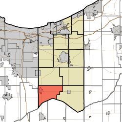
Boone Township, Porter County, Indiana
Boone Township is one of twelve townships in Porter County, Indiana. As of the 2010 census, its population was 6,160.[3]
Cities and towns
The largest community in the township is Hebron.[4]
Education
Boone Township is served by the Metropolitan School District of Boone Township. Their high school is Hebron High School.
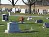
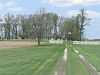
Cemeteries
| Name |
Location |
Picture |
Ref pg[5] |
Ref pg[6] |
| Hebron Cemetery |
900 S and US 231, Hebron |
 |
pg 47 |
back |
| Cornell Cemetery |
North of State Route 8, must north of 350W |
 |
pg 53 |
back |
|
References
- ↑ "US Board on Geographic Names". United States Geological Survey. 2007-10-25. Retrieved 2008-01-31.
- ↑ "American FactFinder". United States Census Bureau. Retrieved 2008-01-31.
- ↑ "Geographic Identifiers: 2010 Demographic Profile Data (DP-1): Boone township, Porter County, Indiana". U.S. Census Bureau, American Factfinder. Retrieved March 22, 2013.
- ↑ Porter County, Indiana Sesquicentennial, 150, 1836-1986
- ↑ Soil Survey of Porter County, Indiana; USDA, Soil Conservation Service, Purdue University Agricultural Experiment Station, Indiana Department of natural Resources, Soil and Water Conservation Committee; February 1981
- ↑ Rand MacNally, Porter County, Indiana, 2001
External links