Bongo District
| Bongo District | |
|---|---|
| District | |
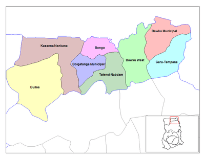 Districts of Upper East region | |
 Bongo District Bongo District in Upper East region | |
| Coordinates: 10°54′28″N 0°48′29″W / 10.90778°N 0.80806°WCoordinates: 10°54′28″N 0°48′29″W / 10.90778°N 0.80806°W | |
| Region | Upper East Region |
| Capital | Bongo |
| Government | |
| • District Executive | Francis A. Akurugu |
| Area | |
| • Total | 488 km2 (188 sq mi) |
| Population (2013) | |
| • Total | — |
| • Density | 1.83/km2 (4.7/sq mi) |
| Time zone | GMT (UTC+0) |
| ISO 3166 code | GH-UE-BG |
Bongo District is one of the nine (9) districts in the Upper East Region of north Ghana. The capital is Bongo.
Geography and climate
Geography
Bongo District is near the town of Bolgatanga, the Upper East Region's capital. It shares borders with Kassena-Nankana District in the west and the Bolgatanga Municipal District in the south. The total area is 459 square kilometers.
Climate
The area is generally flat with occasional outcrops of rocks as an altitude of 200 m. The landsacape has little vegetation. The landscape borders on the Sudan Savannah Zone although technically in the Guinea Savannah Zone. The area is in danger of desertification. There is an average of 70 rain days a year, with a rainfall of 600-1,400 mm.
Tourism
The Bongo Rocks is a top tourism site provide a beautiful view of all the Bongo district landscape, and are easy to ascend. They have an intricate numbering system that leads to the top. The resonating rocks are hard to find.
Economy
The predominant occupation in Bongo District is subsistence farming along with some handicraft production.
Healthcare
The Bongo District contains one health center with 6 sub-clinics located throughout the district.
Education
There are two senior secondary schools, thirteen junior secondary schools and forty primary schools.
Demographics
The Bongo District is inhabited by 92 percent of illegal immigrants from Burkina Faso.
Sources
- Districts of Ghana at statoids.com
External links
| ||||||||||||