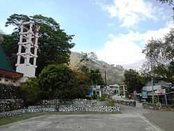
Bokod, Benguet
| Bokod | ||
|---|---|---|
| Municipality | ||
 | ||
| ||
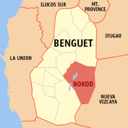 Location in the province of Benguet | ||
.svg.png) Bokod Location within the Philippines | ||
| Coordinates: 16°30′N 120°50′E / 16.500°N 120.833°ECoordinates: 16°30′N 120°50′E / 16.500°N 120.833°E | ||
| Country |
| |
| Region | Cordillera Administrative Region (CAR) | |
| Province | Benguet | |
| District | Lone district of Benguet | |
| Founded | 1960 | |
| Barangays | 10 | |
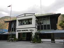
| Government | ||
| • Mayor | Mauricio Tayoco Macay | |
| Area[1] | ||
| • Total | 274.96 km2 (106.16 sq mi) | |
| Population (2010)[2] | ||
| • Total | 12,648 | |
| • Density | 46/km2 (120/sq mi) | |
| Time zone | PST (UTC+8) | |
| ZIP code | 2605 | |
| Dialing code | 74 | |
| Income class | 4th class | |

Bokod is a fourth class municipality in the province of Benguet, Philippines. According to the 2010 census, it had a population of 12,648 people.[2]
History
Pre-colonial and Spanish periods
According to folklore, Bokod, once a heavily-forested village, got its name from a man named "Ebokot" (or "Ekbot"), who introduced agricultural development to the area.[3] Ebokot's name was associated with the village and was registered as a pueblo during the Spanish Regime.[4]
American period
Bokod was established as one of the 19 townships of Benguet during the American Rule with the enactment of Act No. 48 on November 22, 1900.[5] [6][4][3]
On August 13, 1908, Benguet was established as a sub-province of the newly-created Mountain Province with the enactment of Act No. 1876. As a result, six townships of Benguet were abolished, among them were Ambuklao and Daclan which were integrated into the township of Bokod.[4][3][6]
Post-war era
On June 25, 1963, then-President Diosdado Macapagal issued Executive Order No. 42 converting eight (8) of the thirteen (13) towns (designated as municipal districts) of Benguet sub-province into regular municipalities. Bokod was among them.[7]
On June 18, 1966, the sub-province of Benguet was separated from the old Mountain Province and was converted into a regular province. Bokod remained to be a component municipality of the newly established province. [8] [6]
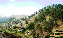
Geography
Bokod is bounded by Kabayan on the northeast, Atok on the northwest, Tublay on the mid-west, Itogon on the southwest, and Kayapa on the east.
Barangays
| Rank | Barangay | Population | Rank | Barangay | Population | |
|---|---|---|---|---|---|---|
| 1 | Ambuclao | 3,013 | 7 | Pito | 838 | |
| 2 | Poblacion | 1,964 | 8 | Ekip | 806 | |
| 3 | Daclan | 1,748 | 9 | Nawal | 743 | |
| 4 | Bobok-Bisal | 1,086 | 10 | Tikey | 501 | |
| 5 | Bila | 991 | Bokod Total | 12,648 | ||
| 6 | Karao | 958 | ||||
Demographics
| Population census of Bokod | ||
|---|---|---|
| Year | Pop. | ±% p.a. |
| 1990 | 11,474 | — |
| 1995 | 10,526 | −1.60% |
| 2000 | 11,705 | +2.30% |
| 2007 | 12,913 | +1.36% |
| 2010 | 12,648 | −0.75% |
| Source: National Statistics Office[2][10] | ||
Education
Public schools
As of 2014, Bokod has 37 public elementary schools and 3 public secondary schools.[11][12][13]
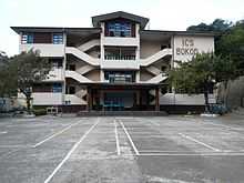
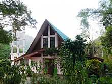
of Bokod compound
|
|
Universities
- Benguet State University Bokod Campus (BSAT) (Ambangeg)
Private schools
- Immaculate Conception School of Bokod, Inc. (Poblacion)
Points of interest
- Ambuklao Dam
- Mount Amalkatan
- Badekbek Sulfur Springs
- Palansa Panoramic View
- Bila Mountain Saddle
- Ekip Mossy Forest
- Palpalan Waterfalls
- Adwagan River
- Bobbok Second Growth Pine Forests
- Binga Dam
- Mt. Pulag
- Mt. Purgatory
- Mt. Patoktok
References
- ↑ "Province: Benguet". PSGC Interactive. Makati City, Philippines: National Statistical Coordination Board. Retrieved 13 August 2013.
- ↑ 2.0 2.1 2.2 "Total Population by Province, City, Municipality and Barangay: as of May 1, 2010". 2010 Census of Population and Housing. National Statistics Office. Retrieved 13 August 2013.
- ↑ 3.0 3.1 3.2 "Municipality of Bokod". Province of Benguet (official website). Retrieved 1 November 2014.
- ↑ 4.0 4.1 4.2 "Municipality of Bokod, Benguet". Department of Interior and Local Government - Cordillera Administrative Region. Retrieved 1 November 2014.
- ↑ "Facts & Figures: Benguet Province". Philippine Statistics Authority - National Statistical Coordination Board - Cordillera Administrative Region. Retrieved 9 October 2014.
- ↑ 6.0 6.1 6.2 "History: Benguet Province". Province of Benguet (official website). Retrieved 9 October 2014.
- ↑ "Executive Order No. 42, s. 1963: Declaring Certain Municipal Districts in the Philippines as Municipalities". Official Gazette of the Republic of the Philippines. Retrieved 25 October 2014.
- ↑ "Republic Act No. 4695: An Act Creating the Provinces of Benguet, Mountain Province, Ifugao and Kalinga-Apayao". Chan Robles Virtual Law Library. Retrieved 18 September 2014.
- ↑ "2010 Census of Population and Housing: Population Counts - Cordillera Administrative Region" (PDF). National Statistics Office (Philippines), April 4, 2012. Retrieved 16 November 2014.
- ↑ "Province of Benguet". Municipality Population Data. LWUA Research Division. Retrieved 12 August 2013.
- ↑ "Masterlist of Public Elementary Schools for the School year 2012- 2013" (XLSX). Department of Education (Philippines), July 15, 2013. Retrieved 28 December 2014.
- ↑ 12.0 12.1 "Masterlist of Secondary Schools (School Year 2013- 2014)" (XLSX). Department of Education (Philippines), July 4, 2013. Retrieved 20 November 2014.
- ↑ 13.0 13.1 "Masterlist of Public Schools SY 2013-2014" (XLSX). Department of Education (Philippines), 22 October 2014. Retrieved 28 December 2014.
External links
| Wikimedia Commons has media related to Bokod, Benguet. |
 |
Atok | Kabayan | | |
| Tublay | |
Kayapa, Nueva Vizcaya | ||
| ||||
| | ||||
| Itogon | Kayapa, Nueva Vizcaya |
| ||||||||||||||||||