Bohol
| Bohol | |||
|---|---|---|---|
| Province | |||
| |||
|
Anthem: Awit sa Bohol[1] Bohol Hymn | |||
 Map of the Philippines with Siquijor highlighted | |||
| Coordinates: 9°53′N 124°13′E / 9.88°N 124.22°ECoordinates: 9°53′N 124°13′E / 9.88°N 124.22°E | |||
| Country | Philippines | ||
| Region | Central Visayas (Region VII) | ||
| Discovered Founded |
25 March 1565 22 July 1854 | ||
| Capital | Tagbilaran | ||
| Government | |||
| • Type | Sangguniang Panlalawigan | ||
| • Governor | Edgar Chatto (LP) | ||
| • Vice governor | Concepcion Lim | ||
| • Council |
Members
| ||
| Area[2] | |||
| • Total | 4,820.95 km2 (1,861.38 sq mi) | ||
| Population (2010)[3] | |||
| • Total | 1,255,128 | ||
| • Density | 260/km2 (670/sq mi) | ||
| • Voters (2013)[4] | 775,785 | ||
| • Languages | |||
| Demonym | Boholano | ||
| Divisions | |||
| • Independent cities | 0 | ||
| • Component cities | 1 | ||
| • Municipalities | 47 | ||
| • Barangay | 1109 | ||
| • Districts | 3 | ||
| Time zone | PHT (UTC+8) | ||
| ZIP code | 6300–6346 | ||
| IDD : | +63 (0)38 | ||
| Income class | 1st class | ||
| PSGC | 071200000 | ||
| Website |
www | ||


Bohol is a first income class island province of the Philippines located in the Central Visayas region, consisting of the island itself and 75 minor surrounding islands.[5] Its capital is Tagbilaran City. With a land area of 4,821 square kilometres (1,861 sq mi) and a coastline 261 kilometres (162 mi) long, Bohol is the tenth largest island of the Philippines.[6] To the west of Bohol is Cebu, to the northeast is the island of Leyte and to the south, across the Bohol Sea is Mindanao.
The province is a popular tourist destination with its beaches and resorts.[7] The Chocolate Hills, numerous mounds of limestone formations, is the most popular attraction. The formations can be seen by land (climbing the highest point) or by air via ultralight airplane tours. Panglao Island, located just southwest of Tagbilaran City, is famous for its diving locations and routinely listed as one of the top ten diving locations in the world. Numerous tourist resorts dot the southern beaches and cater to divers from around the world. The Philippine tarsier, amongst the world's smallest primates, is indigenous to the island.
A narrow strait separates the island of Cebu and Bohol, and both share a common language, but the Boholanos retain a conscious distinction from the Cebuanos. Bohol's climate is generally dry, with maximum rainfall between the months of June and October. The interior is cooler than the coast.
It is the home province of Carlos P. Garcia, the eighth president of the Republic of the Philippines (1957–1961) who was born in Talibon, Bohol.[8]
On 15 October 2013, Bohol was devastated by a 7.2 magnitude earthquake. The epicenter of the earthquake was 6 kilometers south of Sagbayan town. The earthquake, which also devastated neighboring Cebu City, claimed 156 lives and injured 374 people. It also destroyed or damaged a number of Bohol's heritage churches, including the churches of Baclayon, Loboc, Loon, Maribojoc, Loay, Dimiao, and Dauis.[9][10][11]
History
Early history

Bohol was first settled by Australoid people, like the rest of the Philippines. They still inhabit the island today and are known as the Eskaya tribe. Their population also was absorbed into the Austronesian or Malayo-Polynesian peoples who later settled the islands and form the majority of the population. The Austronesian people living on Bohol traded with other islands in the Philippines and as far as China and Borneo.
The people of Bohol are said to be the descendants of a group of inhabitants who settled in the Philippines called pintados or "tattooed ones."[12] Boholanos already had a culture of their own as evidenced by artifacts unearthed at Mansasa, Tagbilaran, and in Dauis and Panglao.
Bohol is derived from the word Bo-ho or Bo-ol.[6] The island was the seat of the first international treaty of peace and unity between the native king Datu Sikatuna and Spanish conquistador Miguel López de Legazpi on March 16, 1565 through a blood compact alliance known today by many Filipinos as the Sandugo.[13]
Spanish colonial period
The earliest significant contact of the island with Spain occurred in 1565. On March 25 (March 16 in the Julian Calendar), a Spanish explorer named Miguel López de Legazpi arrived in Bohol seeking spices and gold. After convincing the native chieftains that they were not Portuguese (who raided the islands of Mactan in 1521), Legazpi made a peace pact with Datu Sikatuna. This pact was signified with a blood compact between the two men.[14] This event, called the Sandugo ("one blood"), is celebrated in Bohol every year during the Sandugo Festival. The Sandugo or blood compact is also depicted on Bohol's provincial flag and the Bohol provincial seal .[15]

Two significant revolts occurred in Bohol during the Spanish Era. One was the Tamblot Uprising in 1621, led by Tamblot, a babaylan or native priest. The other was the famous Dagohoy Rebellion, considered the longest in Philippine history. This rebellion was led by Francisco Dagohoy, also known as Francisco Sendrijas, from 1744 to 1829.[14]
Politically, Bohol was administered as a residencia of Cebu. It became a separate politico-military province on July 22, 1854 together with Siquijor. A census in 1879 found Bohol with a population of 253,103 distributed among 34 municipalities.[16]
Because of the Spanish colonial period, several municipalities in Bohol have names of towns in Spain like Getafe. This municipality is a sister city with the Spanish city of the same name. In Getafe, a street is named Isla de Bohol (Island of Bohol), a unique name for a street in Spain.
The culture of the Boholanos was influenced by Spain and Mexico during colonization. Many traditional dances, music, dishes and other aspects of the culture have considerable Hispanic influence.
U.S. intervention and occupation
After the United States defeated Spain in the Spanish–American War, the U.S. bought the entire Philippine islands. However, under the newly proclaimed independent government established by Gen. Emilio Aguinaldo, which was not recognized by the U.S., Bohol was governed as a Gobierno de Canton.
During the resulting Philippine–American War, American troops peacefully took over the island in March 1899.[17]:528 However, in Jan. 1901, Pedro Sanson led 2,000 in rebellion, due to the harsh treatment received by these troops and the destruction they caused.[17]:528 General Hughes led a campaign of repression in Oct. 1901, destroying a number of towns, threatening in Dec. to burn Tagbilaran if the rebels did not surrender.[17]:528 Pantaleon E. del Rosario then negotiated the rebel surrender.[17]:528
On March 10, 1917, the Americans made Bohol a separate province under Act 2711 (which also established most of the other Philippine provinces).
Japanese occupation and liberation
Japanese troops landed in Tagbilaran on May 17, 1942. Boholanos struggled in a guerilla resistance against the Japanese forces. Bohol was later liberated by the local guerrillas and the Filipino and American troops who landed on April 11, 1945.[18]
A plaque placed on the port of Tagbilaran commemorating the liberation reads:
One thousand one hundred seventy two officers and men of the 3rd Battalion of the 164th Infantry Regiment of the Americal Division under the command of Lt. Col. William H. Considine landed at the Tagbilaran Insular Wharf at 7:00 o'clock in the morning of April 11, 1945.
The convoy taking the Filipino and American liberation forces to Bohol consisted of a flotilla of six landing ships (medium), six landing crafts (infantry), two landing crafts (support), and one landing craft (medium-rocket). Upon arrival, the reinforced battalion combat team advanced rapidly to the east and northeast with the mission of destroying all hostile forces in Bohol. Motor patrols were immediately dispatched by Col. Considine, Task Force Commander, and combed the area to the north and east, approximately halfway across the island, but no enemies were found during the reconnaissance. Finally, an enemy group of undetermined strength was located to the north of Ginopolan in Valencia, near the Sierra-Bullones boundary.
By April 17, the Task Force was poised to strike in Ginopolan. The bulk of the Japanese force was destroyed and beaten in the ten days of action. Bohol was officially declared liberated on May 25, 1945 by Major General William H. Arnold, Commander of the Americal Division. About this time, most officers and men of the Bohol Area Command had been processed by units of the United States Eighth Army.
On May 31, 1945, the Bohol Area Command was officially deactivated upon orders of Lt. General Robert Eichelberger, Commanding General of the Eighth United States Army together with the Philippine Constabulary, the former Philippine Commonwealth Army Forces and the Boholano guerrillas.
During the Second Battle of Bohol in March to August 1945, Filipino troops of the 8th, 83rd, 85th and 86th Infantry Division of the Philippine Commonwealth Army and 8th Infantry Regiment of the Philippine Constabulary captured and liberated the island province of Bohol and helped the Boholano guerrilla fighters and U.S. liberation forces defeat the Japanese Imperial forces under General Sozaku Suzuki.
2013 earthquake
At 8:12 a.m. (PST) on October 15, 2013, the island province suffered a severe earthquake with a magnitude of 7.2 on the Richter scale.[19][20] Its epicenter was at 9°52′N 124°04′E / 9.86°N 124.07°E (6 km (3.7 mi) S 24° W of Sagbayan and 629 kilometres (391 mi) from Manila), and its depth of focus was 12 kilometres (7.5 mi).[19] The quake was felt as far as Davao City, Mindanao. According to official reports by the National Disaster Risk Reduction and Management Council (NDRRMC), 57 people died in Bohol, and 104 were injured.[21]
It was the deadliest earthquake in the Philippines since the 7.8 magnitude 1990 Luzon earthquake.[22] Earlier that same year Bohol was struck by an earthquake (on February 8, 1990) with an epicentre almost exactly the same as in 2013,[23] causing six fatalities and 200 injured. Several buildings were damaged and it caused a tsunami.[24][25]
Geography

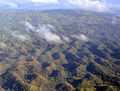
The Chocolate Hills are considered one of Philippine's natural wonders and Bohol is often referred to as the Jewel of the Philippines. They are hills made of limestone leftover from coral reefs during the Ice age when the island was submerged. They turn brown during the summer, hence their name.
There are four main rivers that run through Bohol, with the Loboc River running from the center of the island to the southeastern coast. The largest river, the Inabanga, runs in the northwestern part of the province; the Abatan River runs in the southwest, and Ipil River in the north.
Numerous waterfalls and caves are scattered across the island, including Mag-Aso Falls in Antequera. Mag-Aso means smoke in the native tongue. The water is cool and often creates a mist in humid mornings which can hide the falls.
The Rajah Sikatuna Protected Landscape protects Bohol's largest remaining lowland forest and can be found in the island's southern portion near Bilar.
Physical
With a land area of 4,821 square kilometres (1,861 sq mi) and a coastline 261 kilometres (162 mi) long, Bohol is the tenth largest island of the Philippines. The main island is surrounded by about 70 smaller islands, the largest of which are Panglao Island, facing Tagbilaran City, in the southwest and Lapinig Island in the northeast.
The terrain of Bohol is basically rolling and hilly and about half the island is covered in limestone. Near the outer areas of the island are low mountain ranges. The interior is a large plateau with irregular landforms.
Near Carmen, the Chocolate Hills are more than 1,200 uniformly cone-shaped limestone hills named for the grass growing on the hills that turns brown in the summer, making the landscape look like chocolate mounds. The Chocolate Hills appear on the provincial seal of Bohol.
The outlying islands surrounding mainland Bohol under the jurisdiction of the Bohol Provincial Government are:
- Alicia
- Bagatusan
- Bagong Banwa
- Balicasag
- Banacon
- Banbanan
- Bansaan
- Batasan
- Bay Sa Owak
- Bilangbilangan
- Bonbon
- Bosaan
- Buabuahan
- Bugatusan
- Busalian
- Cabilao
- Cabul-an
- Cabantulan
- Cabgan
- Calangaman
- Cancoslino
- Calituban
- Cataban
- Catang
- Cati-il
- Cuaming
- Gak-ang
- Gaus
- Guindacpan
- Hambongan
- Hingutanan
- Inanoran
- Jaguliao
- Jandayan
- Jao
- Juagdan
- Lapinig
- Lapinin Chico
- Limasoc
- Lumislis
- Ma-agpit
- Mahanay
- Makaina
- Makalingao
- Malingin
- Mantatao Daku
- Mantatao Gamay
- Maomauan
- Maubay
- Mocaboc
- Nasingin
- Nocnocan
- Pamasaun
- Pamilacan
- Pandanon
- Pandao
- Pangangan
- Pangapasan
- Panglao
- Pinango
- Potohan
- Pungtud
- Saag
- Sagasa
- Sandingan
- Sentingnenay
- Silo
- Sinandigan
- Tabangdio
- Talibon
- Talimobo
- Tambo
- Tangtaang
- Tintinan
- Tumok
Climate
From November to April, the northeast monsoon (amihan) prevails. Except for a rare shower, this is the mildest time of the year. Daytime temperatures average 28 °C (82 °F), cooling down at night to around 25 °C (77 °F). The summer season from May to July brings higher temperatures and very humid days. From August to October is the southwest monsoon (habagat). The weather during this season is not very predictable, with weeks of calm weather alternating with rainy days. It can rain any day of the year, but a higher chance of heavy showers occurs from November to January.
Subdivisions
The province of Bohol is a first-class province subdivided into 3 congressional districts, 47 municipalities and 1 city.[26] It has 1,109 barangays[27] (1,114 barangays per NEDA[26]) with a total population of 1,255,128 (2010) and an average household size of 5.41.
| Congr. district | City | Municipality | Population (2010) |
|---|---|---|---|
| 1st | Tagbilaran City | Alburquerque, Antequera, Baclayon, Balilihan, Calape, Catigbian, Corella, Cortes, Dauis, Loon, Maribojoc, Panglao, Sikatuna, Tubigon | 415,420 |
| 2nd | none | Bien Unido, Buenavista, Clarin, Dagohoy, Danao, Getafe, Inabanga, Pres. Carlos P. Garcia, Sagbayan, San Isidro, San Miguel, Talibon, Trinidad, Ubay | 415,878 |
| 3rd | none | Alicia, Anda, Batuan, Bilar, Candijay, Carmen, Dimiao, Duero, Garcia Hernandez, Guindulman, Jagna, Lila, Loay, Loboc, Mabini, Pilar, Sevilla, Sierra Bullones, Valencia | 423,830 |
Demographics

| Population census of Bohol | ||
|---|---|---|
| Year | Pop. | ±% p.a. |
| 1990 | 948,403 | — |
| 1995 | 994,440 | +0.89% |
| 2000 | 1,139,130 | +2.95% |
| 2007 | 1,230,110 | +1.07% |
| 2010 | 1,255,128 | +0.74% |
| Source: National Statistics Office[3][28] | ||
According to the 2010 census, it has a population of 1,255,128.[3] In the last election, it had 775,785 registered voters, meaning that 62% of the population are aged 18 and over.[4]
Economy
Tourism plays an increasing role in the island's economy. An international airport is currently planned for Panglao, which houses the most-visited and accessible beaches in the province. Proponents of the scheme hope that the new airport will increase Bohol's reputation as an international tourist destination although the plan has been dogged by ongoing criticism.[29]
Infrastructure
Airport

Though a number of national flag carriers are already servicing the Tagbilaran City Airport, a proposed international airport (see Panglao Island International Airport) has been planned on the nearby Panglao Island to accommodate bigger aircraft and handle larger volumes of passengers and tourists to the province. The Panglao airport project is controversial. Accordingly, private land in the planned right-of-way that was bought cheaply is being sold expensively, creating further issues and delays.
Seaports
The Port of Tubigon, the busiest among the smaller ports, offers more than ten daily round trips plying the Cebu-Bohol route. The Catagbacan Port in Loon serves the roll-on roll-off services between Cebu and Bohol for those who have vehicles plying this route. The Port of Jagna offers services that ply between Bohol to Cagayan and Camiguin (with roll-on/roll-off) route. The other ports are Ubay, Talibon, Getafe, Buenavista, and Clarin.
Media Organizations
Bohol has 2 major AM radio stations, DYRD and DYTR, both based in Tagbilaran City. Another AM radio station, DYZD, based in Ubay, is being operated by DYRD. Both DYRD and DYTR also operate FM stations with the same names. There are multiple weekly or bi-weekly newspapers like Bohol Chronicle, Sunday Post, Bohol Times, Bohol Standard and Bohol Bantay Balita. An online news website called Bohol News Daily aggregates news from various sources.
Education
The literacy rate of the province of Bohol is high at 98%.[27]
Institutions of Higher Learning:
- Bohol Island State University
- Holy Name University
- University of Bohol
- Bohol Institute of Technology International College(BITIC)
- Immaculate Heart of Mary Seminary
- Mater Dei College
- AMA Computer College of Tagbilaran
- STI College
- Bohol Wisdom School
- Informatics Computer Institute of Tagbilaran
- Bohol Northern Star Colleges
- Philippine Maritime Institute (PMI Colleges)
- Cristal e-College
- Central Visayan Institute Foundation (CVIF)
- Blessed Trinity College (BTC)
- Holy Spirit School
- Dr. Cecilio Putong National High School (DCPNHS)
- Tagbilaran City National Science High School
- Congressman Pablo Malasarte National High School
- Ubay National Science High School
Notable people
- Francisco Dagohoy, revolutionary leader
- Carlos P. Garcia, the eight president of the Republic of the Philippines.
- Dr. José Abueva, former president of the University of the Philippines
- Napoleon Abueva, sculptor
- Rich Asuncion, actress
- Rey Bautista, professional boxer
- Christopher Bernido, physicist, educator, Ramon Magsaysay Awardee
- Ma. Victoria Carpio-Bernido, educator, Ramon Magsaysay Awardee
- Mutya Buena, recording artist
- Tomás Cloma, lawyer and discoverer of the Kalayaan Group of Islands
- Nonito Donaire Jr., professional boxer
- Bernie Fabiosa, athlete
- Anna Maris Igpit, beauty pageant contestant
- Cesar Montano, actor
- Lauro Mumar, athlete
- Luke Mijares, singer
- Cecilio Putong, former Education secretary
- Cathy Remperas, reality TV show participant
- Jerome Sala, singer
- Caesar Saloma, applied physicist, chancellor of University of the Philippines Diliman
- Roman "Yoyoy" Villame, singer and composer
Festivals
- Sandugo Festival (July 1–31)
- Tagbilaran City Fiesta (May 1)
- Saulog Tagbilaran Festival in honor to Saint Joseph the Worker
- Bolibong Kingking Festival (May 23–24) - Loboc, Bohol
- Pana-ad sa Loboc (Holy Thursday & Good Friday) - Loboc, Bohol
- SidlaKasilak or Festival of Lights - Loon (Fiesta Week: August 30 to September 8)
- Sambat Mascara y Regatta Festival (1st Saturday of December) - Loay, Bohol
- Suroy sa Musikero (December 25 - February 2) - Loboc, Bohol
- Bohol Fiestas (month of May)
- Ubi Festival (January)[30]
- Tigum Bol-anon Tibuok Kalibutan or TBTK - "A gathering of Boholanos from different parts of the world and the name for such a grand event"[31]
- Hudyaka sa Panglao (August 27–28) Panglao, Bohol
- Sinulog (3rd Saturday of January) - Valencia, Bohol
- Dujan Festival (3rd to last week of January)- Anda
- Sinuog- Estokada Festival (September 28–29) - Jagna
- Chocolate Hills Festival - Carmen
- Alimango Festival- Mabini
- Humay Festival- Candijay
Gallery
-

Alona beach
-
Bohol interior
-

Loboc river
-

Mahogany forest in Bohol
-
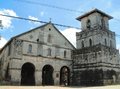
Baclayon church
-

Panglao watchtower
-

Tarsier
-
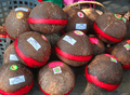
Kalamay delicacy
See also
- Awit sa Bohol - official hymn of the province of Bohol
- Boholano language
- Boholano people
- Diocese of Tagbilaran
- Diocese of Talibon
- Eskaya
- Eskayan language
- List of Bohol Churches
- List of Bohol flora and fauna
- List of Bohol-related topics
References
- ↑ Hellingman, Jeroen. "Provincial Symbols of Bohol". Retrieved 11 September 2014.
- ↑ "List of Provinces". PSGC Interactive. Makati City, Philippines: National Statistical Coordination Board. Retrieved 16 December 2013.
- ↑ 3.0 3.1 3.2 "Total Population by Province, City, Municipality and Barangay: as of May 1, 2010" (PDF). 2010 Census of Population and Housing. National Statistics Office. Retrieved 1 April 2013.
- ↑ 4.0 4.1 "2013 National and Local Elections Statistics". Commission on Elections. 2013.
- ↑ "Bohol Island Philippines". bohol-philippines.com. Retrieved 2009-02-20.
- ↑ 6.0 6.1 The Island-Province of Bohol www.bohol.gov.ph Retrieved November 15, 2006.
- ↑ Socio-economic Profile www.bohol.gov.ph
- ↑ Bountiful Bohol www.aenet.org Retrieved November 15, 2006.
- ↑ Philippines quake hits Cebu and Bohol BBC News. Retrieved on 15 October 2013
- ↑ Strong quake rocks Visayas; 20 dead Rappler.com. Retrieved on 15 October 2013
- ↑ Powerful quake kills 74 people, destroys heritage churches in Bohol, Cebu GMA News Online. Retrieved on 15 October 2013
- ↑ Bohol-The Island Province www.aenet.org Retrieved November 15, 2006.
- ↑ A Short History of Bohol (Part 1) www.bohol.ph Retrieved November 15, 2006.
- ↑ 14.0 14.1 Readings From Bohol's History www.aenet.org, Source: Philippine Political and Cultural History. Volume I. Gregorio F. Zaide Retrieved November 15, 2006.
- ↑ The Bohol Flag and Seal www.bohol.gov.ph Retrieved November 15, 2006.
- ↑ History of Bohol www.bohol.gov.ph Retrieved November 15, 2006.
- ↑ 17.0 17.1 17.2 17.3 Foreman, J., 1906, The Philippine Islands: A Political, Geographical, Ethnographical, Social and Commercial History of the Philippine Archipelago, New York: Charles Scribner's Sons
- ↑ A Short History of Bohol (Part II) www.bohol.ph Retrieved November 15, 2006.
- ↑ 19.0 19.1 "Earthquake Bulletin No. 3: 7.2 Bohol Earthquake". Philippine Institute of Volcanology and Seismology. October 15, 2013. Retrieved October 15, 2013.
- ↑ Bulilit Marquez (October 15, 2013). "Death toll in Philippines quake jumps to 93". Associated Press. Retrieved October 15, 2013.
- ↑ "SitRep No.2 re Effects of Earthquake in Carmen, Bohol" (PDF). National Disaster Risk Reduction and Management Council. October 15, 2013. Retrieved October 15, 2013.
- ↑ Jeannette I. Andrade (October 15, 2013). "Bohol earthquake strongest to hit Visayas and Mindanao in over 20 years". Philippine Daily Inquirer. Retrieved October 15, 2013.
- ↑ "Philippine Earthquake February 8, 1990" (PDF). Retrieved 16 December 2014.
- ↑ Floyd Whaley (October 15, 2013). "Major Earthquake Strikes Central Philippines". The New York Times. Retrieved October 15, 2013.
- ↑ Marc Jayson Cayabyab (October 15, 2013). "Bohol quake as strong as 32 atomic bombs –Phivolcs". GMA News. Retrieved October 15, 2013.
- ↑ 26.0 26.1 The Region www.cvis.net Retrieved November 19, 2006.
- ↑ 27.0 27.1 Bohol Profile Executive Brief www.bohol.gov.ph Retrieved November 19, 2006.
- ↑ "Population and Annual Growth Rates by Province, City and Municipality: Central Visayas: 1995, 2000 and 2007" (PDF). National Statistics Office. Archived from the original (PDF) on 24 June 2011.
- ↑ "Bohol Profile on Infrastructure". Government of Bohol. Archived from the original on 10 October 2006.
- ↑ Bohol to hold ubi festival www.inq7.net Retrieved December 4, 2006
- ↑ Bohol Island Festivals www.hoteltravel.com Retrieved November 19, 2006.
Further reading
- Tirol, Jes Belarmino, "TOPONYMS OF BOHOL AND ITS TOWNS Part 1.", The Bohol Chronicle newspaper, January 9, 2011
- "Information about Bohol", information, April 16, 2013
External links
| Wikimedia Commons has media related to Bohol (province). |
| Wikisource has the text of the 1920 Encyclopedia Americana article Bohol. |
- Official website of the provincial government of Bohol
- Provincial Planning and Development Office of Bohol (includes provincial atlas)
-
 Bohol travel guide from Wikivoyage
 |
Cebu | Cebu Strait | |
Camotes Sea | Leyte | |
| |
Canigao Channel | Southern Leyte | |||
| ||||
| | ||||
| Siquijor | Bohol Sea | Bohol Sea Camiguin, Misamis Oriental |
| |||||||||||||||||||||||||||||||||||||

| ||||||||||||||||||||||||||||||||||


| ||||||||||