Boatin Island
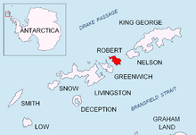 Location of Robert Island in the South Shetland Islands. | |
 Location in Antarctica | |
| Geography | |
|---|---|
| Location | Antarctica |
| Coordinates | 62°20′32.7″S 59°38′55″W / 62.342417°S 59.64861°WCoordinates: 62°20′32.7″S 59°38′55″W / 62.342417°S 59.64861°W |
| Archipelago | South Shetland Islands |
| Country | |
|
None | |
| Demographics | |
| Population | Uninhabited |
| Additional information | |
| Administered under the Antarctic Treaty System | |

Boatin Island (Bulgarian: остров Боатин, ‘Ostrov Boatin’ \'os-trov bo-a-'tin\) is the rocky island off the northwest coast of Robert Island in the South Shetland Islands extending 740 m in north-south direction and 150 m wide. It ends in the T-shaped 250 m wide Hammer Point to the north, and connected to Robert Island to the south by a 250 m long moraine tombolo. The feature was formed as a result of the retreat of Robert Island’s ice cap during the first decade of 21st century. The area was visited by early 19th century sealers.
Location
Boatin Island lies between Clothier Harbour and Nevestino Cove at 62°20′32.7″S 59°38′55″W / 62.342417°S 59.64861°W.
Maps
- Livingston Island to King George Island. Scale 1:200000. Admiralty Nautical Chart 1776. Taunton: UK Hydrographic Office, 1968.
- L.L. Ivanov. Antarctica: Livingston Island and Greenwich, Robert, Snow and Smith Islands. Scale 1:120000 topographic map. Troyan: Manfred Wörner Foundation, 2009. ISBN 978-954-92032-6-4 (Second edition 2010, ISBN 978-954-92032-9-5)
- Antarctic Digital Database (ADD). Scale 1:250000 topographic map. Scientific Committee on Antarctic Research (SCAR), 1993-2012.
References
- Boatin Island. SCAR Composite Antarctic Gazetteer.
- Bulgarian Antarctic Gazetteer. Antarctic Place-names Commission. (details in Bulgarian, basic data in English)
This article includes information from the Antarctic Place-names Commission of Bulgaria which is used with permission.