Boa Vista, Cape Verde
| Native name: <span class="nickname" ">Bubista Nickname: Ilha das dunas (island of the dunes) | |
|---|---|
 | |
 | |
| Geography | |
| Location | Atlantic Ocean |
| Coordinates | 16°6′11.93″N 22°48′12.59″W / 16.1033139°N 22.8034972°W |
| Archipelago | Cape Verde |
| Total islands | 10 |
| Area | 620 km2 (240 sq mi) |
| Length | 31 km (19.3 mi) |
| Width | 29 km (18 mi) |
| Highest elevation | 387 m (1,270 ft) |
| Highest point | Monte Estância |
| Country | |
| Concelhos (Municipalities) | Boa Vista |
| Largest settlement | Sal Rei |
| Demographics | |
| Population | 8554 (as of 2010) |
| Density | 13.8 /km2 (35.7 /sq mi) |
| Additional information | |
| Official website | http://www.boavistaofficial.com |
Boa Vista (Portuguese meaning “good view”) is the easternmost island of Cape Verde. It is located in the Barlavento group of the archipelago. The island is known for marine turtles and traditional music, as well as its ultramarathon and its sand dunes and beaches. The island also constitutes the municipality of Boa Vista, which has two parishes, Santa Isabel and São João Baptista.
Etymology
In the 19th century, the English called Boa Vista, Bonavisa.[1]
Geography
With an area of 620 km², it is the third largest island, after Santo Antão and Santiago. It is 455 km west of the coast of Africa. Much of the island is flat. The highest point on the island is Monte Estância, elevation 387 meters; other mountains include Santo António (Saint Anthony) and Monte Negro (Black Mountain). Other features include Campo da Serra. Its main town is Sal Rei, its ferry port and home to Boa Vista's airport (Rabil Airport)on the northwest side of the island.
Surrounding islets include Ilhéu de Sal Rei featuring a lighthouse in the west, and Ilhéu do Baluate featuring the easternmost point in Cape Verde. Points include Ponta Antónia to the north.
Gallery
-

Boa Vista landscape.
-
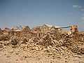
Ruins of the abandoned village Curral Velho.
-

Sal Rei beach
Settlements
- Bofareira
- Cabeço dos Tarrafes
- Curral Velho
- Estância de Baixo
- Fundo das Figueiras
- Gata
- João Barreiro
- João Galego
- Norte
- Povoação Velha
- Rabil
- Sal Rei
- Santo Tirso
Demographics
Population
As of the mid-19th century, the population was estimated at 4,000.[1] While most of the population live in Sal Rei, there are many small settlements with 10 to 100 people; others are abandoned. It has the smallest population of all of inhabited Cape Verde’s islands, and it is the least-dense populated in the archipelago.
| Population of Boa Vista, Cape Verde (1940—2010) | |||||||
|---|---|---|---|---|---|---|---|
| 1940[2] | 1950[2] | 1960[2] | 1970[2] | 1980[2] | 1990[2] | 2000[3] | 2010[4] |
| 2779 | 2985 | 3263 | 3569 | 3372 | 3452 | 4209 | 8554 |
Economy

Its economy was originally based on agriculture, but desertification led to salt collection becoming more important. Its main industries today are date farming and, increasingly, tourism, with already several touristic establishments being built in recent times.
Politics
The Camara Municipal is the main government institution of the island. The current President is José Pinto Almeida, MPD party.
Boavista is twinned with the town of Zocca on May 9, 2014.
Attractions and amenities
Boa Vista has a college (colegio), a middle school, high school, churches, beaches, large hotels, a port, and a square (praça).
Sporting teams
- Academica (Sal-Rei) - Sal-Rei
- Académica Operária
- África Show
- Desportivo Estância Baixo
- Juventude do Norte
- Sanjoanense (Boa Vista)
Notable residents
- Aristides Pereira, Cape Verde's first president
- Germano Almeida, a Capeverdean writer[5]
References
- ↑ 1.0 1.1 Roberts, Edmund (1837). Embassy to the Eastern Courts of Cochin-China, Siam, and Muscat. New York: Harper & Brothers. p. 17.
- ↑ 2.0 2.1 2.2 2.3 2.4 2.5 Source: Statoids
- ↑ Source: Instituto Nacional de Estatísticas.
- ↑ Portal do Instituto Nacional de Estatística: INE - CENSO 2010.
- ↑ Educom.sce.fct.unl.pt
External links
Coordinates: 16°6′11.93″N 22°48′12.59″W / 16.1033139°N 22.8034972°W
| Wikimedia Commons has media related to Boa Vista (Cape Verde). |
| ||||||||||||||||