Blue River Township, Hancock County, Indiana
| Blue River Township | |
|---|---|
| Township | |
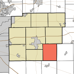 Location in Hancock County | |
| Coordinates: 39°44′41″N 85°40′41″W / 39.74472°N 85.67806°WCoordinates: 39°44′41″N 85°40′41″W / 39.74472°N 85.67806°W | |
| Country | United States |
| State | Indiana |
| County | Hancock |
| Government | |
| • Type | Indiana township |
| Area | |
| • Total | 29.83 sq mi (77.3 km2) |
| • Land | 29.75 sq mi (77.1 km2) |
| • Water | 0.08 sq mi (0.2 km2) 0.27% |
| Elevation | 909 ft (277 m) |
| Population (2010) | |
| • Total | 1,417 |
| • Density | 47.6/sq mi (18.4/km2) |
| GNIS feature ID | 0453117 |
Blue River Township is one of nine townships in Hancock County, Indiana, United States. As of the 2010 census, its population was 1,417 and it contained 542 housing units.[1]
History
Blue River was organized in 1828.[2] It was named from the Blue River, once an important waterway for mills.[3]
Geography
According to the 2010 census, the township has a total area of 29.83 square miles (77.3 km2), of which 29.75 square miles (77.1 km2) (or 99.73%) is land and 0.08 square miles (0.21 km2) (or 0.27%) is water.[1] The streams of Dilly Creek and Nameless Creek run through this township.
Unincorporated towns
(This list is based on USGS data and may include former settlements.)
Adjacent townships
- Jackson Township (north)
- Ripley Township, Rush County (east)
- Hanover Township, Shelby County (south)
- Brandywine Township (west)
- Center Township (northwest)
Cemeteries
The township contains three cemeteries: Gilboa, Haskett, and Westland Friends Church.
References
- Notes
- ↑ 1.0 1.1 "Population, Housing Units, Area, and Density: 2010 - County -- County Subdivision and Place -- 2010 Census Summary File 1". United States Census. Retrieved 2013-05-10.
- ↑ Richman, George J. (1916). History of Hancock County, Indiana: Its People, Industries and Institutions. Wm. Mitchell Printing Company. p. 490.
- ↑ Binford, John H. (1882). History of Hancock County, Indiana: From Its Earliest Settlement by the "pale Face," in 1818, Down to 1882. King & Binford. pp. 49–50.
- Sources
- "Blue River Township, Hancock County, Indiana". Geographic Names Information System. United States Geological Survey. Retrieved 2009-09-24.
- United States Census Bureau cartographic boundary files
External links
| |||||||||||||||||||||||||||||