Blue Canyon, California
| Blue Canyon | |
|---|---|
| Unincorporated community | |
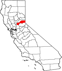
 Blue Canyon Location in California | |
| Coordinates: 39°15′26″N 120°42′40″W / 39.25722°N 120.71111°WCoordinates: 39°15′26″N 120°42′40″W / 39.25722°N 120.71111°W | |
| Country |
|
| State |
|
| County | Placer County |
| Elevation[1] | 4,695 ft (1,431 m) |
Blue Canyon (also, Blue Cañon) is an unincorporated community in Placer County, California.[1] Blue Canyon is located 4 miles (6.4 km) southwest of Emigrant Gap.[2] It lies at an elevation of 4695 feet (1431 m).[1]
Blue Canyon may have been named for the blue smoke of the camps when extensive lumbering occurred there in the 1850s. Also, it may have been named after a miner from that same period named "Old Jim Blue".[3]
The Blue Canyon post office operated from 1867 to 1927. The Blue Cañon post office operated from 1936 to 1942 and from 1948 to 1964.[2]
Blue Canyon receives more annual snowfall than any other community in the contiguous 48 U.S. states (unpopulated mountain peaks excluded).[4]
See also
- Blue Canyon – Nyack Airport
- Extremes on Earth
- List of weather records
References
- ↑ 1.0 1.1 1.2 U.S. Geological Survey Geographic Names Information System: Blue Canyon, California
- ↑ 2.0 2.1 Durham, David L. (1998). California's Geographic Names: A Gazetteer of Historic and Modern Names of the State. Clovis, Calif.: Word Dancer Press. p. 452. ISBN 1-884995-14-4.
- ↑ Gudde, Erwin G. (1998). California place names : the origin and etymology of current geographical names (4th ed., rev. and enl. ed.). Berkeley: University of California Press. p. 39. ISBN 0520213165.
- ↑ "Snowfall (Including Ice Pellets and Sleet) - Average Total in Inches". Comparative Climatic Data for the United States Through 2012. National Oceanic and Atmospheric Administration: U.S. Dept. of Commerce. 2013.