Bloomington Township, Buchanan County, Missouri
| Bloomington Township | |
|---|---|
| Township | |
 | |
| Coordinates: 39°35′08″N 094°56′37″W / 39.58556°N 94.94361°WCoordinates: 39°35′08″N 094°56′37″W / 39.58556°N 94.94361°W | |
| Country | United States |
| State | Missouri |
| County | Buchanan |
| Area | |
| • Total | 35.44 sq mi (91.8 km2) |
| • Land | 35.44 sq mi (91.8 km2) |
| • Water | 0 sq mi (0 km2) 0% |
| Elevation[1] | 1,017 ft (310 m) |
| Population (2000) | |
| • Total | 699 |
| • Density | 19.7/sq mi (7.6/km2) |
| FIPS code | 29-06418[2] |
| GNIS feature ID | 0766337 |
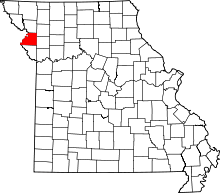
Bloomington Township is one of twelve townships in Buchanan County, Missouri, USA. As of the 2000 census, its population was 699.
Geography
Bloomington Township covers an area of 35.44 square miles (91.8 km2) and contains one incorporated settlement, De Kalb. It contains two cemeteries: Jones and West Lawn.
The stream of South Sugar Creek runs through this township.
References
- ↑ "US Board on Geographic Names". United States Geological Survey. 2007-10-25. Retrieved 2008-01-31.
- ↑ "American FactFinder". United States Census Bureau. Retrieved 2008-01-31.
External links
| |||||||||||||||||||||||||||||