Blanchard River
| Blanchard River | |
|---|---|
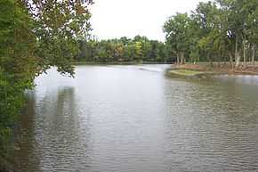 The Blanchard River in Findlay | |
| Origin | ~ 5 mi (8 km) northwest of Kenton |
| Mouth | Auglaize River near Dupont |
| Length | 103 miles (166 km) |
| Mouth elevation | 686 ft (209 m) [1] |
| Basin area | 771 mi² (1997 km²) [2] |
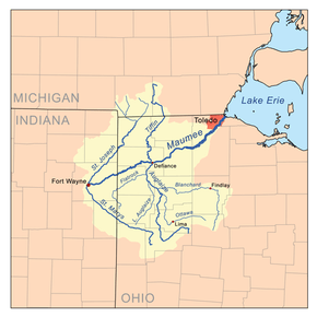
The Blanchard River is a 103-mile-long (166 km)[3] tributary of the Auglaize River in northwestern Ohio in the United States. It drains a primarily rural farming area in the watershed of Lake Erie.
It rises in central Hardin County, on the northern outskirts of Kenton. It flows generally north for its first 25 miles (40 km) into eastern Hancock County, where it turns sharply to the west. It flows west through Findlay and past Ottawa. It joins the Auglaize from the east in western Putnam County approximately 2 miles (3 km) north of Cloverdale at 41°02′29″N 84°17′57″W / 41.041483°N 84.299245°W.
History
The river is named for Jean Jacques Blanchard, a French tailor who settled among the Shawnee along the river in 1769. Fort Findlay, an American outpost in the War of 1812, was constructed along the river in 1812 at the site of the present-day city of Findlay.
In 1908, Tell Taylor wrote Down by the Old Mill Stream, a popular song of the early 20th Century and a barbershop favorite, while sitting on the banks of the Blanchard River.
Flooding
in August 2007 flooding along the Blanchard River caused more than $100 million in damage in Findlay and an estimated $12 million in damage in Ottawa.[4] Flooding in Ottawa is aggravated by the low bridge across I-9 in Putnam County that traps debris and forms a dam during floods. Flooding also caused damage in Findlay in March, 2011.
On November 28, 2012, officials from Hancock and Putnam Counties travelled to Washington D.C. to lobby for $1.7 million in federal funding to complete phase three of the Blanchard River Flood Mitigation study.[5]
Variant names
According to the Geographic Names Information System, the Blanchard River has also been known as:[1]
- Quegh-tua-wa
- Queghtuwa
- Blanchard Fork
- Blanchard's Fork
- Blanchards Fork
- Quegh-tu-wa
- Sha-po-qua-te-sepe
- Sha-po-qua-te-sepi
- Tailor's River
- Tailors River
See also
References
- ↑ 1.0 1.1 U.S. Geological Survey Geographic Names Information System: Blanchard River
- ↑ "Map of Ohio watersheds".
- ↑ U.S. Geological Survey. National Hydrography Dataset high-resolution flowline data. The National Map, accessed May 19, 2011
- ↑ Regional officials push for completion of flood control study along river in northwest Ohio.
- ↑ Local Delegation Meeting With Leaders In Washington D.C.