Bishop Wilton Wold
| Bishop Wilton Wold | |
|---|---|
 The summit | |
| Elevation | 807 ft (246 m) |
| Prominence | c. 203 m |
| Listing | Marilyn, County Top |
| Location | |
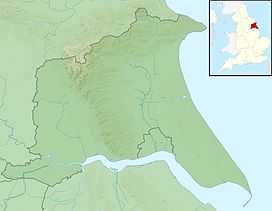 Bishop Wilton Wold Bishop Wilton Wold in the East Riding of Yorkshire | |
| Location | Yorkshire Wolds, England |
| OS grid | SE820569 |
| Coordinates | 54°00′06″N 0°45′02″W / 54.00163°N 0.75049°WCoordinates: 54°00′06″N 0°45′02″W / 54.00163°N 0.75049°W |
| Topo map | OS Landranger 106 |
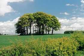
Bishop Wilton Wold is the highest point of the Yorkshire Wolds in the East Riding of Yorkshire, England. The summit, known as Garrowby Hill, lies about 5 miles (8 km) north of Pocklington.
As with most of the wolds, it is wide, flat and agricultural in nature. The A166 road passes right by the top. However it is a Marilyn (having topographic prominence of at least 150m). There is a trig point, two covered reservoirs and an aerial.
The British artist David Hockney painted the view from the summit in 1998.
Halifax bomber crash 1944
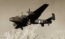
Around 10 am on 7 February 1944[1] an Halifax MkV DK192 (OO-N) from 1663 HCU based at RAF Rufforth[2] crashed on Garrowby Hill.[3]
As well as the 7 aircrew who were on a training flight, a passing lorry driver was also killed. There is a memorial in a layby on the A166 at Garrowby Hill
References
- ↑ "York Stories - Memorials: lost crews of World War Two". Retrieved 27 July 2010.
- ↑ "Royal Air Force - RAF History Bomber Command". Retrieved 27 July 2010.
- ↑ "Yorkshire Aircraft- accidents". Retrieved 27 July 2010.
External links
| ||||||||||||||||||||||||||||||||||||||||||||