Birrego, New South Wales
| Birrego New South Wales | |
|---|---|
|
Birrego to Sandigo road | |
|
Birrego | |
| Coordinates | 35°00′S 146°35′E / 35.000°S 146.583°ECoordinates: 35°00′S 146°35′E / 35.000°S 146.583°E |
| Postcode(s) | 2652 |
| Location | |
| LGA(s) | Narrandera Shire |
| County | Mitchell |
| State electorate(s) | Cootamundra |
| Federal Division(s) | Riverina |

Birrego is a rural locality in the central part of the Riverina near Boree Creek.[2] The countryside is flat and used predominantly for grain production. It is situated by road, about 13 kilometres south from Sandigo and 31 kilometres south east from Morundah.
Birrego Post Office opened on 27 September 1921 and closed in 1959.[3]
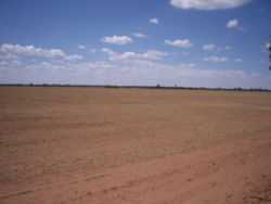
Birrego wheat country
Notes and references
- ↑ Travelmate
- ↑ "Birrego". Geographical Names Register (GNR) of NSW. Geographical Names Board of New South Wales.
- ↑ Premier Postal History, Post Office List, retrieved 2009-06-11
| Wikimedia Commons has media related to Birrego, New South Wales. |