Birmingham Corporation Tramways
For the football club, see Birmingham Corporation Tramways F.C..
| Birmingham Corporation Tramways | |
|---|---|
 Birmingham Corporation Tram in 1953, shortly before the service was scrapped. | |
| Operation | |
| Locale | Birmingham |
| Open | 4 January 1904 |
| Close | 4 July 1953 |
| Status | Closed |
| Infrastructure | |
| Track gauge | 3 ft 6 in (1,067 mm) |
| Propulsion system(s) | Electric |
| Statistics | |
| Route length | 80.5 miles (129.6 km) |

Map of the tram routes in 1930

Remains of tram track in Edmund Street, Birmingham
Birmingham Corporation Tramways operated a network of tramways in Birmingham from 1904 until 1953. It was the largest narrow-gauge tramway network in the UK, built to a gauge of 3 ft 6 inches. It was the largest tramway network in the UK after London, Glasgow and Manchester.
There were a total of 843 trams (with a maximum of 825 in service at any one time), 20 depots, 45 main routes and a total route length of 80 1⁄2 miles (129.6 km).[1]
Birmingham Corporation built all the tramways and leased the track to various companies.
Birmingham was a pioneer in the development of reserved trackways which served the suburban areas as the city grew in the 1920s and 1930s.
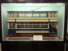
Model of a BCT tram, at the National Tramway Museum
History
- 4 January 1904 – commence tramway at Aston Road North
- 1 January 1907 – took over some City of Birmingham Tramways Company Ltd routes, (CBTC was a British Electric Traction controlled company) - majority of the company's routes having been owned by Birmingham Corporation from their inception.
- 1 July 1911 – took over the former cable tramway to Handsworth[2]
- 1 January 1912 – took over lines owned by Erdington Urban District Council, but operated by Birmingham Corporation Tramways, which subsequently passed into the hands of Birmingham Corporation following expansion of the city's boundaries in 1911.
- 1 January 1912 – took over City of Birmingham Tramways Company Ltd - remainder of the company's routes, ownership of which had passed to Birmingham Corporation from the local councils of Aston Manor, Handsworth, and King's Norton & Northfield, following expansion of the city boundaries in 1911.
- 1 April 1924 – took over operation of West Bromwich Corporation-owned lines previously leased to the Birmingham and Midland Tramways Joint Committee South Staffordshire Tramways Company, a British Electric Traction subsidiary
- 1 April 1928 – took over Birmingham and Midland Tramways Joint Committee Birmingham and District Power and Traction Co Ltd - main line to Dudley.
- 18 October 18 October 1927 – name changed to Birmingham Corporation Tramway and Omnibus Department.
- 9 November 1937 – name changed to Birmingham City Transport.
Routes
Tram no 395 seen preserved at Thinktank, Birmingham Science Museum
| Route | Description | Abandoned | Short workings | |
|---|---|---|---|---|
| 2 | Steelhouse Lane to Erdington | 4 June 1953 | 59 Steelhouse Lane to Gravelly Hill, 60 Steelhouse Lane to Aston Cross, 64 Steelhouse Lane to High Street, Erdington | |
| 3 | Martineau Street to Witton via Six Ways | 11 September 1939 | ||
| 3x | Martineau Street to Witton via Aston Cross | 31 December 1949 | ||
| 4 | Station Street to Stoney Lane | 5 January 1937 | ||
| 5 | Lozells to Gravelly Hill | 30 September 1950 | ||
| 6 | Martineau Street to Perry Barr | 21 December 1949 | ||
| 7 | Martineau Street to Nechells | |||
| 8 | Martineau Street to Alum Rock | 30 September 1950 | 61 Martineau Street via the Gate Inn, Saltley to Pelham Arms (Sladefield Road) | |
| 10 | Martineau Street to Washwood Heath | 30 September 1950 | 9 Martineau Street to Ward End Fox & Goose Pub, 62 inward working of route 10 | |
| 15 | High Street to South Yardley | 2 October 1948 | 13 High Street to Small Heath Park, 56 High Street to Hay Mills | |
| 16 | Station Street to South Yardley | 6 January 1934 | 14 Station Street to Small Heath Park, 57 Station Street to Hay Mills | |
| 17 | High Street to Stratford Road (College Road) | 5 January 1937 | 19 High Street to Stratford Road (St. John's Street), 58 High Street to Stoney Lane/Stratford Road, 82 High Street to Stratford Road (Fox Hollies Road/Highfields Road) | |
| 18 | Station Street to Stratford Road | 5 January 1937 | 21 Station Street to Stratford Road (College Road) | |
| 20 | Station Street to Stratford Road (St. John's Road) | |||
| 22 | Station Street to Bolton Road | 4 February 1930 | ||
| 23 | Colmore Row to Handsworth | 1 April 1939 | 28 Colmore Row to New Inns, Crocketts Lane, Handsworth | |
| 24 | Colmore Row to Lozells via Wheeler Street (clockwise 25) | 1 April 1939 | ||
| 25 | Colmore Row to Lozells via Wheeler Street (anticlockwise 24) | 7 August 1933 | ||
| 26 | Colmore Row to Oxhill Road | 1 April 1939 | 27 Colmore Row to Stafford Road, Soho Road, Handsworth | |
| 29 | City to Bearwood via Dudley Road | 30 September 1939 | 30 Edmund Street to Windmill Lane, Cape Hill, Smethwick, 55 Edmund Street to Dudley Road/Grove Lane | |
| 31 | Edmund Street to Soho | 30 September 1939 | ||
| 32 | Edmund Street to Lodge Road | 29 March 1947 | ||
| 33 | Navigation Street to Ladywood | 30 August 1947 | ||
| 34 | Navigation Street to Bearwood via Hagley Road | 9 August 1930 | ||
| 36 | City to Cotteridge | 5 May 1952 | 46 Navigation Street to Stirchley | |
| 37 | City to Cannon Hill Park | 1 October 1949 | ||
| 39 | City to Alcester Lanes End | 1 October 1949 | 38 Hill Street to High Street/Vicarage Road, Kings Heath via Balsall Heath, 49 Navigation Street to Mary Street/Park Road, Balsall Heath, 52 Hill Street to Station Road, Kings Heath via Balsall Heath, 66 Hill Street to Moseley via Balsall Heath | |
| 42 | City to Alcester Lanes End | 1 October 1949 | 43 High Street to Station Road, Kings Heath via Moseley Road, 48 High Street to High Street/Vicarage Road, Kings Heath, 67 Dale End to Moseley via Bradford Street | |
| 44 | Dale End/Albert Street to Acocks Green | 5 January 1937 | 91 High Street to Warwick Road, Tyseley | |
| 45 | Dale End/Albert Street to Sparkbrook | 5 January 1937 | ||
| 50 | High Street to Moseley Road depot | 1 October 1949 | 41 Navigation Street to Moseley Road Depot | |
| 51 | Hill Street to Alcester Lane End | 1 October 1949 | 40 Hill Street to High Street/Vicarage Road, Kings Heath via Leopold Street, 65 Hill Street to Moseley via Leopold Street | |
| 53 | Navigation Street to Dogpool Lane | |||
| 63 | Steelhouse Lane to Fort Dunlop | 4 July 1953 | ||
| 68 | Villa Road to Soho Road, Lozells, Gravelly Hill and Erdington (Sundays only) | 1923 | ||
| 70 | Navigation Street to Rednal | 5 July 1952 | 35 Navigation Street to Selly Oak, 54 Navigation Street to Pebble Mill Road, 69 Navigation Street to Northfield, 72 Navigation Street to Longbridge | |
| 71 | Navigation Street to Rubery | 5 July 1952 | ||
| 74 | City to Dudley | 1 April 1939 | 74 Livery Street to Carters Green, West Bromwich, 76 Colmore Road to Great Bridge, 77 Colmore Row to Spon Lane/High Street, West Bromwich | |
| 75 | City to Wednesbury | 1 April 1939 | ||
| 78 | Steelhouse Lane to Short Heath | 4 July 1953 | 1 Steelhouse Lane to Stockland Green | |
| 79 | Steelhouse Lane to Pype Hayes Park | 4 July 1953 | 63 Steelhouse Lane to Holly Lane/Tyburn Road | |
| 81 | Villa Road to Soho Road, Lozells to Pype Hayes (Sundays only) | 1930 | ||
| 84 | City to Stechford | 2 October 1948 | 12 High Street to Bordesley Green (Blake Street) via Deritend and Coventry Road | |
| 87 | City to Dudley | 30 September 1939 | 85 Edmund Street to Spon Lane, West Bromwich via Smethwick, 86 Edmund Street to Oldbury via Smethwick, 88 Windmill Lane to Spon Lane, West Bromwich via Smethwick | |
| 90 | City to Stechford | 2 October 1948 | 11 High Street to Bordesley Green (Blake Lane) via Fazeley Street | |
Depots and Works

Former tram depot, Selly Oak
Witton Tram depot
- Arthur Street Depot see Coventry Road
- Birchfield Road Depot, acquired from Handsworth District Council 1911, converted to motorbus use 28 October 1925
- Bournbrook, Dawlish Road, acquired 1 January 1912, closed 11 July 1927 (replaced by Selly Oak)
- Cotteridge Depot, acquired from King's Norton and Northfield District Council 1912
- Coventry Road Depot (also known as Arthur Street Depot), opened 1907, converted to motorbus use 1 July 1951
- Handsworth Sub-Depot
- Highgate Road Depot, opened 25 November 1913
- Hockley Depot, acquired from Handsworth District Council 1912, converted to motorbus use 2 April 1939, (Motor buses ceased 2006)
- Kyotts Lake Road Works, opened 1907, closed August 1953
- Miller Street Depot, opened 4 January 1904, converted to motorbus use 4 July 1953
- Moseley Road Depot, opened 1907, converted to motorbus use 2 October 1949
- Rosebery Street Depot, opened 1 July 1906, converted to motorbus use 31 August 1947
- Selly Oak Depot, opened 8 July 1927, converted to motorbus use 6 July 1952
- Trafalgar Road Depot
- Tividale B.M.T.C.J. Works
- Washwood Heath Depot, opened 1907, converted to motorbus use 1 October 1950
- West Smethwick Depot
- Witton Depot, acquired 1912. Until 2011, Aston Manor Road Transport Museum [3]
Tramcar fleet
Tram no 395 seen at Thinktank, Birmingham set up as route 78 to Short Heath
| Numbers | Year | Seating capacity | Withdrawn | Notes |
|---|---|---|---|---|
| 1 to 2 | 1903 | 28/28 | 1940-41 | Destroyed in air raids |
| 3 | 1903 | 28/28 | 1949 | |
| 4 to 7 | 1903 | 28/28 | 1940-41 | Destroyed in air raids |
| 8 to 9 | 1903 | 28/28 | 1949 | |
| 10 to 12 | 1903 | 28/28 | 1940-41 | Destroyed in air raids |
| 13 | 1903 | 28/28 | 1949 | |
| 14 | 1903 | 28/28 | 1940-41 | Destroyed in air raids |
| 15 | 1903 | 28/28 | 1949 | |
| 16 | 1903 | 28/28 | 1940-41 | Destroyed in air raids |
| 17 to 20 | 1903 | 28/28 | 1949 | |
| 21 to 40 | 1905 | 26/22 | 1930-37 | |
| 41 to 70 | 1905-6 | 26/22 | 1930-37 | |
| 71 to 106 | 1906 | 28/24 | 1937-39 | |
| 107 | 1906 | 28/24 | 1937-39 | Under restoration at Aston Manor Road Transport Museum |
| 108 to 220 | 1906-7 | 28/24 | 1937-39 | |
| 221 to 270 | 1907 | 26/22 | 1930-37 | |
| 271 to 300 | 1908 | 26/22 | 1930-37 | |
| 301 to 302 | 1911 | 28/24 | 1950 | |
| 303 | 1911 | 28/24 | 1940 | Damaged in air raid |
| 304 to 306 | 1911 | 28/24 | 1950 | |
| 307 | 1911 | 28/24 | 1940 | Damaged in air raid |
| 308 to 323 | 1911 | 28/24 | 1950 | |
| 324 | 1911 | 28/24 | 1940 | Damaged in air raid |
| 325 to 359 | 1911 | 28/24 | 1950 | |
| 360 | 1911 | 28/24 | 1940 | Damaged in air raid |
| 361 to 389 | 1911-12 | 28/24 | 1950 | |
| 390 | 1911-12 | 28/24 | 1940 | Damaged in air raid |
| 391 to 394 | 1911-12 | 28/24 | 1950 | |
| 395 | 1911-12 | 28/24 | 1950 | Preserved at Thinktank, Birmingham Science Museum |
| 396 to 400 | 1911-12 | 28/24 | 1950 | |
| 401 to 438 | 1912 | 30/24 | 1949 | |
| 439 | 1912 | 30/24 | 1941 | |
| 449 to 450 | 1912 | 30/24 | 1949 | |
| 451 to 452 | 1912 | 34/34 | 1949 | |
| 453 to 468 | 1903 | 26/22 | 1937-39 | |
| 469 to 472 | 1904 | 26/22 | 1925-38 | |
| 473 | 1903 | 29/26 | 1924 | |
| 474 to 475 | 1903 | 29/26 | 1938 | |
| 476 to 477 | 1903 | 29/26 | 1924 | |
| 478 | 1903 | 29/26 | 1938 | |
| 479 | 1903 | 29/26 | 1924 | |
| 480 | 1903 | 29/26 | 1938 | |
| 481 to 483 | 1904 | 26/22 | 1938-39 | |
| 484 to 501 | 1904-05 | 26/22 | 1937-39 | |
| 502 to 511 | 1904-05 | 26/22 | 1913–1928 | |
| 512 to 524 | 1913-14 | 34/28 | 1950-53 | |
| 525 | 1913-14 | 34/28 | ???? | Withdrawn during WWII |
| 526 to 537 | 1913-14 | 34/28 | 1950-53 | |
| 538 | 1913-14 | 34/28 | ???? | Withdrawn during WWII |
| 539 to 563 | 1913-14 | 34/28 | 1950-53 | |
| 564 | 1913-14 | 34/28 | 1941 | Destroyed in air raid |
| 565 to 566 | 1913-14 | 34/28 | 1950-53 | |
| 567 to 568 | 1913-14 | 34/28 | 1941 | Destroyed in air raid |
| 569 to 573 | 1913-14 | 34/28 | 1950-53 | |
| 574 to 575 | 1913-14 | 34/28 | 1941 | Destroyed in air raid |
| 576 to 581 | 1913-14 | 34/28 | 1950-53 | |
| 582 | 1913-14 | 34/28 | 1941 | Destroyed in air raid |
| 583 to 586 | 1913-14 | 34/28 | 1950-53 | |
| 587 to 636 | 1920-21 | 34/28 | 1949-53 | |
| 637 to 661 | 1923-24 | 35/28 | 1952-53 | |
| 662 | 1924 | 35/28 | 1952-53 | |
| 663 | 1924 | 35/28 | 1941 | Destroyed in air raid |
| 664 to 668 | 1924 | 35/28 | 1952-53 | |
| 669 to 670 | 1924 | 35/28 | 1941 | Destroyed in air raid |
| 671 to 679 | 1924 | 35/28 | 1952-53 | |
| 680 to 681 | 1924 | 35/28 | 1941 | Destroyed in air raid |
| 682 to 684 | 1924-25 | 35/28 | 1952-52 | |
| 685 | 1924-25 | 35/28 | 1941 | Destroyed in air raid |
| 686 to 696 | 1924-25 | 35/28 | 1952-53 | |
| 697 | 1924-25 | 35/28 | 1941 | Destroyed in air raid |
| 698 | 1924-25 | 35/28 | 1952-53 | |
| 699 | 1924-25 | 35/28 | 1941 | Destroyed in air raid |
| 700 to 701 | 1924-25 | 35/28 | 1952-53 | |
| 702 to 703 | 1925 | 35/28 | 1940-41 | |
| 704 to 706 | 1925 | 35/28 | 1952 | |
| 707 to 708 | 1925 | 35/28 | 1940-41 | |
| 709 to 710 | 1925 | 35/28 | 1952 | |
| 711 | 1925 | 35/28 | 1940-41 | |
| 712 to 713 | 1925 | 35/28 | 1952 | |
| 714 | 1925 | 35/28 | 1940-41 | |
| 715 to 717 | 1925 | 35/28 | 1952 | |
| 718 | 1925 | 35/28 | 1940-41 | |
| 719 | 1925 | 35/28 | 1952 | |
| 720 | 1925 | 35/28 | 1940-41 | |
| 721 to 722 | 1925 | 35/28 | 1952 | |
| 723 to 724 | 1925 | 35/28 | 1940-41 | |
| 725 to 726 | 1925 | 35/28 | 1952 | |
| 727 | 1925 | 35/28 | 1940-41 | |
| 728 to 731 | 1925 | 35/28 | 1952 | |
| 732 to 761 | 1926 | 35/28 | 1952 | |
| 762 to 784 | 1928 | 35/27 | 1952 | |
| 785 | 1928 | 35/27 | 1941 | Destroyed in air raid |
| 786 to 811 | 1928 | 35/27 | 1952 | |
| 812 to 820 | 1928-29 | 35/27 | 1952 | |
| 821 | 1928-29 | 35/27 | 1941 | |
| 822 to 841 | 1928-29 | 35/27 | 1952 | |
| 842 | 1929 | 36/27 | 1952 | |
| 843 | 1930 | 33/27 | 1952 | |
Statistics
| Year | No of vehicles | Miles run | Passengers | Revenue |
|---|---|---|---|---|
| 1904 to 1905 | 20 | 266,526 | 4,709,798 | £19,103 (£1,789,826 in 2015),[4] |
| 1913 to 1914 | 551 | 14,268,244 | 146,930,986 | £635,471 (£53,211,183 in 2015),[4] |
| 1923 to 1924 | 658 | 17,521,741 | 214,338,365 | £1,337,093 (£66,539,410 in 2015),[4] |
| 1933 to 1934 | 762 | 17,368,227 | 201,442,970 | £1,171,481 (£72,565,659 in 2015),[4] |
| 1943 to 1944 | 499 | 11,206,698 | 130,665,152 | £1,088,824 (£41,843,607 in 2015),[4] |
| 1953 to 1954 | 120 | 3,391,580 | 35,554,412 | £398,122 (£9,510,551 in 2015),[4] |
Surviving artifacts and infrastructure
Tramcars
- Vehicle 107 (1906) under restoration at Aston Manor Road Transport Museum
- Vehicle 395 (1911) rescued by City of Birmingham Museums and Galleries. Restored in 1953 and presented to Birmingham Science Museum. Now preserved in Thinktank, Birmingham Science Museum
Shelters

Tramway shelter from Birmingham preserved at the Crich Tramway Museum
- One preserved at Crich Tramway Museum (53°05′23″N 1°29′09″W / 53.089842°N 1.485869°W)
Depots
- Moseley Road Depot - Grade II listed.[5] (52°27′15″N 1°53′09″W / 52.4543°N 1.8857°W)
- Selly Oak Depot, Harborne Lane - now Storage Units. (52°26′31″N 1°56′34″W / 52.44189°N 1.94268°W)
- Witton Depot (52°30′42″N 1°53′07″W / 52.511651°N 1.885399°W)
- Silver Street, Kings Heath - now International Stock (52°26′00″N 1°53′38″W / 52.43345°N 1.89402°W)
- Miller Street - First Corporation built depot (52°29′34″N 1°53′37″W / 52.49274°N 1.89348°W)
- Highgate Road. Closed to trams 1937. Used for buses until the 1950s. (52°27′31″N 1°52′27″W / 52.45872°N 1.87418°W)
- Steam Tram coke yard, 1899 - Stratford Road/ College Road junction.
Track

Remains of tram track, Rednal Terminus
- Edmund Street, Birmingham City Centre (52°28′50″N 1°54′13″W / 52.48054°N 1.90348°W)
- Rednal Terminus (52°23′02″N 2°00′07″W / 52.384012°N 2.002013°W)
See also
- History of Birmingham
- Transport in Birmingham
- Trolleybuses in Birmingham
- Midland Metro
- List of town tramway systems in the United Kingdom
References
Notes
- ↑ Birmingham City Transport, Malcolm, etc. Keeley, Transport Pub. Co 1978 ISBN 0-903839-18-0
- ↑ Tramways of the Black Country: Company-operated Lines of South Staffordshire and North Worcestershire, J S Webb Staffs., 1954
- ↑ Aston Manor Road Transport Museum
- ↑ 4.0 4.1 4.2 4.3 4.4 4.5 UK CPI inflation numbers based on data available from Gregory Clark (2014), "What Were the British Earnings and Prices Then? (New Series)" MeasuringWorth.
- ↑ Historic England. "Moseley Road Depot (Grade II) (1386758)". National Heritage List for England. Retrieved 19 January 2015.
Literature
- Great British Tramway Networks, Wingate H. Bett and John C. Gillham, Light Railway Transport League 1st edition 1940 and 2nd edition 1944
- The ABC of Birmingham City transport. Parts 1 & 2, W. A Camwell, Ian Allan 1950
- City of Birmingham Transport Department. 1904-1954: Brochure to commemorate the undertaking's jubilee, Birmingham Transport Committee 1954
- The demise of Birmingham's Trams, Gordon P. Laker - copy in Birmingham Central Library
- Birmingham Trams and Tramways, Colin Andrew Purdue - copy in Birmingham Central Library
- Memories of Birmingham's steam trams, C Gilbert, Light Railway Transport League 1966
- Short review of Birmingham Corporation tramways, Peter Laurence Hardy, H.J. Publications1971 ISBN 0-9502035-0-5
- Birmingham (British tramways in pictures, 3), R.J.S. Wiseman, Huddersfield, Advertiser Press, 1972, ISBN 0-900028-11-4
- Birmingham Transport, Alec G Jenson, Birmingham Transport Historical Group 1978 ISBN 0-905103-00-9
- Birmingham City Transport, Malcolm, etc. Keeley, Transport Pub. Co 1978 ISBN 0-903839-18-0
- Birmingham Corporation Trams and Trolleybuses, Archie Mayou, Senior Publications 1982 ISBN 0-903839-83-0
- Birmingham Corporation Tramway Rolling Stock. The story of Birmingham tramcar design, development and maintenance, P.W. Lawson, Birmingham Transport Historical Group 1983
- Last Tram Down the Village and Other Memories of Yesterday's Birmingham, Ray Tennant and Jim Lyndon, BiginInk Ltd 1984 ISBN 0-948025-01-8
- Memories of Birmingham's transport, A.N.H Glover, 1987 ISBN 0-905103-06-8
- Birmingham in the Electric Tramway Era, D.F. Potter, Birmingham Transport Historical Group 1988 ISBN 0-905103-10-6
- Memories of Birmingham Transport, D.R. Harvey Birmingham Transport Historical Group 1988 ISBN 0-905103-09-2
- Birmingham Trams on Old Picture Postcards, John Marks, Reflections of a Bygone Age 1992 ISBN 0-946245-53-3
- A Nostalgic Look at Birmingham Trams, 1933-53: The Northern Routes Vol 1, David Harvey, Silver Link Publishing Ltd 1993 ISBN 1-85794-014-8
- A Nostalgic Look at Birmingham Trams, 1933-53: The Southern Routes - Bristol Road Routes, Cotteridge and the Moseley Road Routes, Plus Nechells and Bolton Road Vol 2, David Harvey, Silver Link Publishing Ltd 1994 ISBN 1-85794-021-0
- A Nostalgic Look at Birmingham Trams, 1933-53: The Eastern and Western Routes - Including the Stechford Routes, the West Bromwich, Wednesbury and Dudley Routes and the Smethwick, Oldbury and Dudley Routes v. 3, David Harvey, Silver Link Publishing Ltd 1995 ISBN 1-85794-037-7
- Birmingham Trams, Silver Link Publishing Ltd 1995 ISBN 1-85794-992-7
- Birmingham Transport (Archive Photographs: Images of England), Keith Turner, Tempus Publishing Ltd 1998 ISBN 0-7524-1554-9
- The Tramways of the West Midlands, LRTA handbook 1999 ISBN 0-948106-23-9
- Birmingham Corporation Transport, 1904-39, Paul Collins, Ian Allan Ltd 1999ISBN 0-7110-2627-0
- Birmingham Corporation Transport, 1939-69, Paul Collins, Ian Allan Ltd 1999ISBN 0-7110-2656-4
- Birmingham Transport (Sutton's Photographic History of Transport), Mike Hitches, Sutton Publishing 1999 ISBN 0-7509-1670-2
- Seeing Birmingham by Tram, Eric Armstrong, Tempus Publishing Ltd 2003 ISBN 0-7524-2787-3
- Roads & Rails of Birmingham 1900-1939, R.T. Coxon, Ian Allen Ltd. 1979 ISBN 0-7110-0913-9
Video and DVD
- Birmingham trams and trolleybuses, Birmingham Transport Historical Group 1992, VHS, 90min, also DVD published by Online Video
- Another look at Birmingham's trams and buses, John Stanford, 1999 VHS