Birdsville
| Birdsville Queensland | |||||||
|---|---|---|---|---|---|---|---|
|
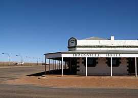
The Birdsville Hotel, adjacent to the apron of Birdsville Airport. | |||||||
 Birdsville Location in Queensland | |||||||
| Coordinates | 25°53′56″S 139°21′06″E / 25.89889°S 139.35167°ECoordinates: 25°53′56″S 139°21′06″E / 25.89889°S 139.35167°E | ||||||
| Population | 115 (2006 census)[1] | ||||||
| Established | 1887 | ||||||
| Postcode(s) | 4482 | ||||||
| Elevation | 46.5 m (153 ft) | ||||||
| Location | |||||||
| LGA(s) | Diamantina Shire | ||||||
| State electorate(s) | Mount Isa | ||||||
| Federal Division(s) | Maranoa | ||||||
| |||||||
Birdsville is a small town located on land traditionally owned by the Wangkanguru People, in the Channel Country of Central West Queensland, Australia. It is 1,590 kilometres (990 mi) west of the state capital, Brisbane, and 720 kilometres (450 mi) south of the city of Mount Isa. Birdsville is on the edge of the Simpson Desert, approximately 174 km east of Poeppel Corner and the climate is very arid. At the 2011 census, Birdsville had a population of 295,[2] but the current population is about 100.
History
Birdsville was known as Diamantina Crossing from 1881.[3] There are a number of different theories as to the origin of the name. One is that the name derives from the prolific bird life in the district.[4] The other is that a store was established by Percy Bird and George Field and they called it Birdfield. However, in 1882, G. and R. Wills, of Adelaide, misaddressed a consignment of goods as going to Birdsville and that name stuck.[5] Another is that a man named Burt established a store and called it Burtsville which corrupted to Birdsville.[6] Whatever its origin, by 1882, the name Birdsville was in common use[7] and was formalised at the proclamation of town in 1887.
Birdsville Post Office opened on 1 January 1883.[8]
Birdsville was located at the border of South Australia and Queensland to collect tolls from the droves of cattle being moved interstate.
Many of Australia's pioneering European explorers travelled through the Birdsville district well before the town was gazetted. Monuments to acknowledge the feats of Captain Charles Sturt, Burke & Wills, Cecil Madigan and others are located throughout the town.
Birdsville had a population of over 300 at the turn of the twentieth century. It had three hotels, a cordial factory, blacksmith store, market gardens, police and customs facilities but after Federation in 1901, the tolls were abolished and the town fell into decline [9] to about 50 people throughout the 1950s. Livestock trade kept the region alive and in recent times tourism has joined cattle as the major industry in the area.
Heritage listings
Birdsville has a number of heritage-listed sites, including:
- Adelaide Street: Australian Inland Mission Hospital (former)[10]
- Adelaide Street: Birdsville Courthouse[11]
- Adelaide Street: Royal Hotel/Australian Inland Mission Hospital (former)[12]
- Burt Street: Birdsville Hotel[13]
- Eyre Developmental Road: Carcory Homestead Ruin[14]
- Glengyle Station: Kidman's Tree of Knowledge[15]
Geography
Birdsville is located by the Diamantina River in the Diamantina Shire, which has a population of 326 persons (Census 2001). The Birdsville Track extends 514 kilometres (319 mi) from Marree in South Australia through the Strzelecki Desert before ending at Birdsville.
Facilities
When proclaimed the town had three hotels, two stores, a customs house for interstate trade, a police station and a large collection of commercial buildings but in 2007 there was just one hotel serving canned or bottled beer, library, visitor information centre, museum and a hospital.[16] Today Birdsville is a popular tourist destination with many people using it as a stopping point across the Simpson Desert.
It is also known for the annual Birdsville Races, which are held in September each year in aid of the Royal Flying Doctor Service of Australia. The town's tiny population is augmented by between 7000 to 9000 people for the two-day event, and hundreds of aircraft fill the town's 1,700 metres (1,859 yd) airstrip.[17] In 2010 the races were cancelled for the first time in the event's history due to rain. There are many other events, such as "The Big Red Run" and the "Big Red Bash", held at Birdsville throughout the winter tourist season.
Birdsville also has an 80 kW geothermal power station, the only one of its type in Australia.[18] Water is extracted from an 80-year-old bore on the Great Artesian Basin at 98 °C and is used to heat the operating fluid isopentane in a Rankine Cycle engine. The geothermal plant produces around one third of the town's electricity. The water (once cooled) is also the source of the town's drinking water.[19]
Birdsville boasts a state primary school (with a current enrollment of three children), a police station manned by one officer and a hospital staffed by one nurse.
The town is situated near a billabong on which a pontoon was built to facilitate swimming and non-powered boating activities, and which in 2012 was home to a stray freshwater crocodile.[20][21]
Climate
Birdsville has an arid climate with on average only 22 days of rain in a year. Summers are extremely hot and dry, with winters being mild to warm. The median annual rainfall at Birdsville is 133 mm.[22] The actual amount of rain which falls is highly variable, for example, in 1914 just 14 mm was recorded while 659 mm fell in 1917. Dust storms are most likely during periods of strong wind which typically occur in spring.[22] Birdsville has recorded the hottest confirmed temperature in the state of Queensland, with 49.5 °C (121.1 °F) having been recorded on more than one occasion.
| Climate data for Birdsville Police Station | |||||||||||||
|---|---|---|---|---|---|---|---|---|---|---|---|---|---|
| Month | Jan | Feb | Mar | Apr | May | Jun | Jul | Aug | Sep | Oct | Nov | Dec | Year |
| Record high °C (°F) | 48.5 (119.3) |
45.9 (114.6) |
46.5 (115.7) |
41.7 (107.1) |
37.8 (100) |
32.4 (90.3) |
33.4 (92.1) |
36.2 (97.2) |
42.4 (108.3) |
45.1 (113.2) |
48.7 (119.7) |
49.5 (121.1) |
49.5 (121.1) |
| Average high °C (°F) | 38.8 (101.8) |
37.8 (100) |
35.1 (95.2) |
30.3 (86.5) |
24.8 (76.6) |
21.6 (70.9) |
20.8 (69.4) |
23.5 (74.3) |
28.1 (82.6) |
32.1 (89.8) |
35.5 (95.9) |
37.7 (99.9) |
30.5 (86.9) |
| Average low °C (°F) | 24.2 (75.6) |
24.1 (75.4) |
21.1 (70) |
16.2 (61.2) |
11.3 (52.3) |
7.9 (46.2) |
6.6 (43.9) |
8.3 (46.9) |
12.2 (54) |
16.1 (61) |
19.7 (67.5) |
22.5 (72.5) |
15.8 (60.4) |
| Record low °C (°F) | 12.2 (54) |
13.9 (57) |
9.4 (48.9) |
6.0 (42.8) |
1.7 (35.1) |
−1.7 (28.9) |
−1.7 (28.9) |
0.4 (32.7) |
1.5 (34.7) |
2.8 (37) |
8.5 (47.3) |
10.9 (51.6) |
−1.7 (28.9) |
| Average precipitation mm (inches) | 24.7 (0.972) |
29.0 (1.142) |
16.4 (0.646) |
9.5 (0.374) |
11.8 (0.465) |
10.4 (0.409) |
10.9 (0.429) |
6.4 (0.252) |
5.7 (0.224) |
12.1 (0.476) |
13.5 (0.531) |
16.0 (0.63) |
167.0 (6.575) |
| Avg. precipitation days | 2.5 | 2.4 | 1.7 | 1.2 | 1.7 | 1.8 | 1.6 | 1.3 | 1.3 | 2.3 | 2.3 | 2.5 | 22.6 |
| Source: [23] | |||||||||||||
Birdsville disease
Birdsville disease is an illness observed in horses, caused by eating the native plant Birdsville indigo (Indigofera linnaei) which contain natural toxins including the neurotoxin 3 nitropropionic acid (3-NPA). The affected horses exhibit weakness and lack of coordination; it can be fatal. It does not appear to affect cattle.[24] Although it is not unique to Birdsville, the condition was first observed in the Birdsville district in May 1886.[25] While there were many theories about the cause of the disease including plants, worms and sunstroke, it was not until 1950 that researchers identified the precise cause.[26] Mildly affected horses can recover with a regime of drenching with gelatine and feeding a diet high in arginine but euthanasia is recommended for severely affected horses. As there is no cure, preventing horses from grazing on indigo is recommended.[24]
In popular culture
- Elizabeth Haran's 2004 novel Stars in the Southern Sky is set in the town (though renamed to Kangaroo Crossing).
- The 2014 British comedy The Inbetweeners 2 had scenes set in the town.
References
- ↑ Australian Bureau of Statistics (25 October 2007). "Birdsville (Diamantina Shire) (State Suburb)". 2006 Census QuickStats. Retrieved 2009-03-20.
- ↑ "2011 Census QuickStats – Bedourie". Australian Bureau of Statistics. Retrieved 5 August 2012.
- ↑ "Birdsville". Queensland Holidays. Tourism Queensland. Retrieved 11 March 2012.
- ↑ "Birdsville (entry 47588)". Queensland Place Names. Queensland Government. Retrieved 10 May 2014.
- ↑ "NOMENCLATURE OF QUEENSLAND.—42.". The Courier-Mail (Brisbane: National Library of Australia). 16 November 1935. p. 12. Retrieved 11 May 2014.
- ↑ "OUT WEST IN 80.". The Register (Adelaide: National Library of Australia). 15 November 1926. p. 7. Retrieved 11 May 2014.
- ↑ "THE FAR NORTH.". The Sydney Morning Herald (National Library of Australia). 19 August 1882. p. 9. Retrieved 11 May 2014.
- ↑ Premier Postal History. "Post Office List". Premier Postal Auctions. Retrieved 10 May 2014.
- ↑ "About Birdsville, history". Birdsville Race Club Inc. Archived from the original on 2006-10-25. Retrieved 2007-01-07.
- ↑ "Australian Inland Mission Hospital (former) (entry 28739)". Queensland Heritage Register. Queensland Heritage Council. Retrieved 2013-07-07.
- ↑ "Birdsville Courthouse (entry 15235)". Queensland Heritage Register. Queensland Heritage Council. Retrieved 2013-07-07.
- ↑ "Royal Hotel/Australian Inland Mission Hospital (former) (entry 15234)". Queensland Heritage Register. Queensland Heritage Council. Retrieved 2013-07-07.
- ↑ "Birdsville Hotel (entry 15236)". Queensland Heritage Register. Queensland Heritage Council. Retrieved 2013-07-07.
- ↑ "Carcory Homestead Ruin (entry 15233)". Queensland Heritage Register. Queensland Heritage Council. Retrieved 2013-07-07.
- ↑ "Kidman's Tree of Knowledge (entry 15237)". Queensland Heritage Register. Queensland Heritage Council. Retrieved 2013-07-07.
- ↑ "Birdsville". Flinders Ranges Research. Retrieved 2007-01-07.
- ↑ "Birdsville Race Club". Birdsville Race Club Inc. Archived from the original on 2006-10-25. Retrieved 2007-01-07.
- ↑ "New power station for Birdsville". The North West Star (Fairfax Media). 23 February 2012. Retrieved 11 March 2012.
- ↑ "Birdsville geothermal power station (pdf)" (PDF). Queensland Sustainable Energy Innovation Fund. September 2007. Archived from the original (PDF) on 2006-07-16. Retrieved 2007-01-07.
- ↑ Chrissy Arthur & Julia Harris (20 February 2012). "A pontoon for Birdsville's billabong". ABC Western Queensland (Australian Broadcasting Corporation). Retrieved 11 March 2012.
- ↑ "Birdsville croc catches sun". ABC Western Queensland. 19 June 2013. Retrieved 30 July 2013.
- ↑ 22.0 22.1 Hesse, Paul B. (2010). "The Australian desert dunefields: formation and evolution in an old, flat, dry continent". In Bishop, P.; Pillans, B. Australian Landscapes. London: Geological Society. p. 145.
- ↑ "BOM".
- ↑ 24.0 24.1 "Birdsville Disease" (PDF). Agnote. Northern Territory Government. Retrieved 11 May 2014.
- ↑ "Agricultural and Pastoral.". The Queenslander (National Library of Australia). 8 May 1886. p. 750. Retrieved 11 May 2014.
- ↑ "HORSE DISEASE TRACED TO NATIVE PLANT.". The Advertiser (Adelaide: National Library of Australia). 26 May 1950. p. 5. Retrieved 11 May 2014.