Billy Mitchell (volcano)
| Billy Mitchell volcano | |
|---|---|
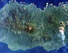 The dark-colored caldera lake of Billy Mitchell is at right, above an ash plume originating from Bagana. | |
| Elevation | 1,544 m (5,066 ft) |
| Location | |
| Location | Bougainville, Papua New Guinea |
| Range | Emperor Range |
| Coordinates | 6°06′S 155°13′E / 6.100°S 155.217°ECoordinates: 6°06′S 155°13′E / 6.100°S 155.217°E |
| Geology | |
| Type | Pyroclastic shield |
| Volcanic arc/belt | Bougainville & Solomon Is. |
| Last eruption | 1580 ± 20 years |
| Billy Mitchell | |
|---|---|
| Location | Bougainville Island |
| Coordinates | 6°06′00″S 155°13′00″E / 6.1°S 155.21667°E |
| Type | crater lake |
| Basin countries | Papua New Guinea |
| Surface area | ~3 square kilometres (1.2 sq mi)[1] |
| Max. depth | ~90 metres (300 ft)[1] |
Billy Mitchell is a volcano in the central part of the island of Bougainville, just northeast of the Bagana Volcano in Papua New Guinea. It is a small pyroclastic shield truncated by a 2 km wide caldera filled by a crater lake.[2]
The last two major eruptions were in 1580 AD ± 20 years and about 1030 AD. They were among the largest Holocene eruptions in Papua New Guinea. Both were explosive eruptions with a Volcanic Explosivity Index of at least 5. The 1580 AD ± 20 years eruption produced pyroclastic flows and probably formed its caldera.[3] The ignimbrite deposit from that eruption, which had a VEI of 6, extends 22 kilometres (14 mi) from the caldera to the coast, and its volume is around 10 cubic kilometres (2.4 cu mi).[1]
See also
- List of volcanoes in Papua New Guinea
- Mount Billy Mitchell (Chugach Mountains)
- Timetable of major worldwide volcanic eruptions
References
- ↑ 1.0 1.1 1.2 The Billy Mitchell volcano at VolcanoLive.com
- ↑ The Billy Mitchell at the Global Volcanism Program website
- ↑ The Billy Mitchell erupts at the Global Volcanism Program website
External links
- Photo of the Billy Mitchell Crater Lake
- "Billy Mitchell". Global Volcanism Program. Smithsonian Institution. Retrieved 2011-11-08.