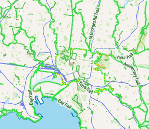
Bike paths in Melbourne

Bike paths around Melbourne have developed since the campaigns of Bicycle Network and the strong awareness that nine editions of the Bike Paths Guides have created of the network . Since with increased recognition from all levels of government of the benefit of cycling activities, Melbourne today has a comprehensive set of shared bicycle trails along its river and creek systems, next to its freeways and along its train lines.[1][2][3]
The length of the trails in Melbourne, as of 2014, totals around 1,900 km. It is possible to cycle from Werribee in the west to Research in the east (approx 62 km) and Craigieburn in the north and Seaford in the south (about 78 km) and points in between and only have to travel on the occasional piece of road. Often passing through relaxed park surrounds, cycling on many of Melbourne's bike paths can feel like a day out in the country despite remaining within metropolitan Melbourne. Melbourne's bike paths are often easily accessed from its train system.
The latest 2014 edition of the Bike Paths and Rail Trail Guide shows the complete metro network in great detail together with path descriptions and more than 18 destination country rail trails. (www.bikepaths.com.au)
Usage
In 2006 VicRoads installed bicycle counters on the trails, at seventeen locations throughout inner Melbourne.[4] These counters are providing hard data on the usage of Melbourne's trails. For example: the Anniversary Outer Circle Trail at Cotham Rd Kew, has about 20 cyclists per hour throughout the day, whereas the Yarra River Trail, north side of Morell Bridge, has a distinct peak hour rate of about 250/hr and 50/hr in non-peak periods.[5][6] This supports the casual observation that the former is used mainly for recreation and the latter for recreation and commuting.
Bike paths along freeways
A number of freeways have been constructed with dedicated separate bicycle paths built alongside, including Eastlink, the Deer Park Bypass, and the Metropolitan Ring Road. However, the CityLink tollway system was built without including provision for cyclists along several sections including the Bolte Bridge. Cyclists are also excluded from riding the West Gate Freeway over the West Gate Bridge, although exceptions are made for some special bicycle events like Around the Bay in a Day organised by Bicycle Victoria. The Westgate Punt ferry service provides an alternative to the bridge.
Future expansion
In December 2008 the Victorian State Government (then Labour) released their Victorian Transport Plan which budgeted $100 million for cycling over 12 years. In 2009, the Victorian Cycling Strategy was also released. However the Victorian Auditor-General reviewed this Strategy in 2012 and found there had been almost no progress on the items in the Plan, which included more cycle lanes and junction treatments, and that it had been sidelined by the new Liberal government.[7] In 2012 there was an outcry from cyclists followed the almost total deletion of cycling projects from the State budget, with protests organised by Bicycle Network Victoria.[8]
Parks Victoria strategy includes expanding the trails [9]
Development of the network is slowed by the number of agencies that may be involved when a new path is proposed. Such agencies could include VicRoads, VicTrack, Parks Victoria, Melbourne Water and the local Councils. The network is clearly fragmented along Council boundaries. Some examples would include:
- the St Georges Rd Trail at the boundary of Darebin and Whittlesea
- the Gardiners Creek gap at the boundary of Boroondara, Stonnington and Monash
- the termination of the East Malvern Station to Centre Rd Trail at the boundary of Monash and Kingston
See also
- Cycling in Melbourne
- Bikepaths & Rail Trail guide
- Category:Bike paths in Melbourne
- Cycling in Victoria
- Bicycle Victoria
- Category:Rail trails in Australia
References
- ↑ VicRoads - Bicycle Route Maps
- ↑ Melbourne and Geelong's shared paths in Google Maps
- ↑ Melbourne and Geelong's shared paths in Google Earth
- ↑ "VicRoads bicycle counters - Google Maps". maps.google.com. Retrieved 2008-07-14.
- ↑ "VicRoads: Cycling Data and Statistics". www.vicroads.vic.gov.au. Retrieved 2008-07-14.
- ↑ Lucas, Clay (March 12, 2006). "Have helmet, bell, two wheels — will commute". The Age (Melbourne: www.theage.com.au). Retrieved 2008-07-14.
- ↑ http://blogs.crikey.com.au/theurbanist/2011/08/20/is-the-auditor-general-on-track-with-cycling/ Alan Davies in Crikey
- ↑ "Baillieu put under the pump on cycling budget". The Age (Melbourne).
- ↑ Linking People and Spaces (2002)
External links
- Bike paths guide - sample information based on published book
- VicRoads - Principle Bicycle Network
- Melbourne bike routes @ bikely.com
- Where to Ride Melbourne cycling guide book
| ||||||||||