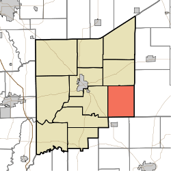
Bigger Township, Jennings County, Indiana
| Bigger Township | |
|---|---|
| Township | |
 Location in Jennings County | |
| Coordinates: 38°57′23″N 85°29′40″W / 38.95639°N 85.49444°WCoordinates: 38°57′23″N 85°29′40″W / 38.95639°N 85.49444°W | |
| Country | United States |
| State | Indiana |
| County | Jennings |
| Government | |
| • Type | Indiana township |
| Area | |
| • Total | 30.74 sq mi (79.6 km2) |
| • Land | 30.69 sq mi (79.5 km2) |
| • Water | 0.05 sq mi (0.1 km2) 0.16% |
| Elevation | 745 ft (227 m) |
| Population (2010) | |
| • Total | 726 |
| • Density | 23.7/sq mi (9.2/km2) |
| GNIS feature ID | 0453111 |
Bigger Township is one of eleven townships in Jennings County, Indiana, United States. As of the 2010 census, its population was 726 and it contained 298 housing units.[1]
History
Bigger Township was established in 1840. It was named for Samuel Bigger, seventh Governor of Indiana.[2]
Geography
According to the 2010 census, the township has a total area of 30.74 square miles (79.6 km2), of which 30.69 square miles (79.5 km2) (or 99.84%) is land and 0.05 square miles (0.13 km2) (or 0.16%) is water.[1]
Unincorporated towns
Adjacent townships
- Campbell Township (north)
- Shelby Township, Ripley County (east)
- Monroe Township, Jefferson County (southeast)
- Lancaster Township, Jefferson County (south)
- Lovett Township (west)
- Vernon Township (west)
Cemeteries
The township contains three cemeteries: Bethel, Callicotte and Hughes.
Airports and landing strips
- Broomsage Ranch Airport
References
- "Bigger Township, Jennings County, Indiana". Geographic Names Information System. United States Geological Survey. Retrieved 2009-09-24.
- United States Census Bureau cartographic boundary files
- ↑ 1.0 1.1 "Population, Housing Units, Area, and Density: 2010 - County -- County Subdivision and Place -- 2010 Census Summary File 1". United States Census. Retrieved 2013-05-10.
- ↑ Jennings Co. Historical Society (1999). Jennings Co, Indiana - Pictorial. Turner Publishing Company. p. 29.
External links
| |||||||||||||||||||||||||||||||||