Big Traverse Bay Historic District
|
Big Traverse Bay Historic District | |
 | |
 | |
| Nearest city | Lake Linden, Michigan |
|---|---|
| Coordinates | 47°11′35″N 88°14′12″W / 47.19306°N 88.23667°WCoordinates: 47°11′35″N 88°14′12″W / 47.19306°N 88.23667°W |
| Area | 9 acres (3.6 ha) |
| Governing body | Local |
| NRHP Reference # | 75000946[1] |
| Significant dates | |
| Added to NRHP | November 20, 1975 |
| Designated MSHS | February 21, 1975[2] |
The Big Traverse Bay Historic District is a historic district located east of Lake Linden, Michigan at the mouth of the Traverse River. It was listed on the National Register of Historic Places in and designated a Michigan State Historic Site in 1975.[1][2]
History

The site on which the Big Traverse Bay Historic District now stands was originally a logging camp owned by the Hebard Lumber Company, dating from the last two decades of the 19th century.[2] A substantial number of Finnish emigres moved into the area, working in the lumber, mining, or fishing industries. By 1920, Big Traverse Bay had developed into a primarily fishing community. in the 1950s, construction of a breakwater and changes to the harbor resulted in the demolition of a number of houses, as well as a footbridge across the river. The community remains an active, and relatively isolated, fishing community.[2]
Description
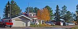
Big Traverse Bay is a small Finnish fishing community located on a peninsula and adjacent mainland at the mouth of the Traverse River on Lake Superior.[2] The community includes approximately 40 small, single-story, gable-roofed houses with aluminum siding an undeveloped yards. Vintage gasoline pumps, net reels, cedar shake-covered fishing buildings, ice houses and saunas are still in use.[2]
References
- ↑ 1.0 1.1 "National Register Information System". National Register of Historic Places. National Park Service. 2009-03-13.
- ↑ 2.0 2.1 2.2 2.3 2.4 2.5 "Big Traverse Bay Historic District". Michigan State Housing Development Authority: Historic Sites Online. Retrieved May 24, 2011.
| ||||||||||||||||||||||||||