Big Sandy Regional Airport
| Big Sandy Regional Airport | |||||||||||
|---|---|---|---|---|---|---|---|---|---|---|---|
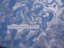 K22 aerial photo January 21, 2009 | |||||||||||
| IATA: none – ICAO: KSJS – FAA LID: SJS | |||||||||||
| Summary | |||||||||||
| Airport type | Public | ||||||||||
| Owner | Big Sandy Regional Airport Board | ||||||||||
| Serves | Prestonsburg, Inez, Paintsville | ||||||||||
| Elevation AMSL | 1,221 ft / 372 m | ||||||||||
| Coordinates | 37°45′04″N 082°38′12″W / 37.75111°N 82.63667°W | ||||||||||
| Website | BigSandyRegional.com | ||||||||||
| Runways | |||||||||||
| |||||||||||
| Statistics (2006) | |||||||||||
| |||||||||||
Big Sandy Regional Airport (ICAO: KSJS, FAA LID: SJS) (formerly K22) is a public use airport located in southwest Martin County, Kentucky, United States.[2] The airport is nine nautical miles (17 km) northeast of the central business district of Prestonsburg,[1] a city in Floyd County. It is owned by the Big Sandy Regional Airport Board.[1]
Facilities and aircraft
Big Sandy Regional Airport covers an area of 136 acres (55 ha) at an elevation of 1,221 feet (372 m) above mean sea level. It has one asphalt paved runway designated 3/21 which measures 5,000 by 100 feet (1,524 x 30 m).[1]
For the 12-month period ending September 21, 2006, the airport had 6,400 aircraft operations, an average of 17 per day: 81% general aviation, 14% air taxi and 5% military. At that time there were 17 aircraft based at this airport: 76% single-engine, 6% multi-engine, 6% jet and 12% helicopter.[1]
References
External links
- FAA Terminal Procedures for SJS, effective April 2, 2015
- Resources for this airport:
- FAA airport information for SJS
- AirNav airport information for SJS
- FlightAware airport information and live flight tracker
- SkyVector aeronautical chart for SJS