Big Rock (glacial erratic)
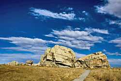
Big Rock (also known as Okotoks Erratic) is a glacial erratic situated 7 km (4.3 mi) west of the town of Okotoks, Alberta, Canada (18 km (11 mi) south of Calgary). The 16,500-tonne (18,200-ton) quartzite boulder is the world's largest known glacial erratic.[1]
History
Big Rock is one of several thousand erratics found in Alberta and Montana called the Foothills Erratics Train, which originated from a landslide in the Tonquin Valley of Jasper National Park, from Lower Cambrian-aged Gog Group.[2] Big Rock was transported along the confluence of the Cordilleran Ice Sheet and the Laurentide Ice Sheet approximately 12 to 18 thousand years ago [3][4] to its present location.
The people of the Blackfoot First Nation used Big Rock as a landmark for finding a crossing over the Sheep River (where Okotoks stands today) long before European settlement. The town's name, Okotoks, is derived from "o'kotok" [ˈokətok], meaning "rock" in the Blackfoot language, and may refer to the rock.[5] The rock also contains native pictographs and was considered a medicine rock to the natives. In the 1970s the government declared it a Provincial Historic Site to protect its geological and cultural importance.
James Hector, a geologist with the Palliser Expedition, first documented the rock in 1863. He misidentified the feature as a klippe.[2]
Present day
The erratic is clearly visible from the side of Highway 7, and public parking is available at the turn-off. While there is a fence around the Big Rock and a sign telling people not to climb, many people visit the rock and ignore the warnings to either boulder or climb the 9-metre (30 ft) tall erratic.
In popular culture
Big Rock Brewery in Calgary is named after Big Rock.
References
- ↑ "Okotoks Erratic". Government of Alberta.
- ↑ 2.0 2.1 Lionel E. Jackson, Jr., Elizabeth R. Leboe, Edward C. Little, Philip J. Holme, Stephen R. Hicock, and Kazuharu Shimamura (1999). "CANQUA 99 Guidebook: Late Quaternary Geology of the Foothills, from Calgary to the Alberta–Montana Border".
- ↑ Jackson, Lionel E.; Fred M. Phillips; Edward C. Little (1999). "Cosmogenic 36Cl dating of the maximum limit of the Laurentide Ice Sheet in southwestern Alberta". Canadian Journal of Earth Sciences 36 (8): 1347–1356. doi:10.1139/cjes-36-8-1347.
- ↑ Jackson, Lionel E.; Elizabeth R. Leboe; Edward C.Little; Phillip J. Holme; Stephen R. Hicock; Kazuharu Shimamura; Faye E. Nelson (2008). "Quaternary stratigraphy and geology of the Rocky Mountain Foothills, southwestern Alberta". Geological Survey of Canada Bulletin 583. doi:10.4095/224301.
- ↑ Town of Okotoks - Okotoks' Beginnings Retrieved 2012-02-09
| ||||||||||||||||||||||||||||||||||||||||
Coordinates: 50°42′21.18″N 114°04′35.12″W / 50.7058833°N 114.0764222°W