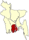
Bhola Sadar Upazila
| Bhola Sadar ভোলা সদর | |
|---|---|
| Upazila | |
 Bhola Sadar Location in Bangladesh | |
| Coordinates: 22°41.4′N 90°39.2′E / 22.6900°N 90.6533°ECoordinates: 22°41.4′N 90°39.2′E / 22.6900°N 90.6533°E | |
| Country |
|
| Division | Barisal Division |
| District | Bhola District |
| Area | |
| • Total | 413.16 km2 (159.52 sq mi) |
| Population (1991) | |
| • Total | 351,674 |
| • Density | 851/km2 (2,200/sq mi) |
| Time zone | BST (UTC+6) |
| Website | Official Map of the Bhola Sadar Upazila |
Bhola Sadar (Bengali: ভোলা সদর) is an Upazila of Bhola District in the Division of Barisal, Bangladesh.
Geography
Bhola Sadar is located at 22°41′25″N 90°39′09″E / 22.6903°N 90.6525°E. It has 62,042 households and a total area of 413.16 km2 (159.52 sq mi).
Demographics
According to the 1991 Bangladesh census, Bhola Sadar had a population of 351,674. Males constitute 51.94% of the population, and females 48.06%. The population aged 18 or over was 160,353. Bhola Sadar had an average literacy rate of 25.8% (7+ years), compared to the national average of 32.4%.[1]
Administration
Bhola Sadar has 16 Unions/Wards, 123 Mauzas/Mahallas, and 123 villages.
Notable people
- Kobi Mozammel Haque
- Leader Tofael Ahmed MP
- Late Leader Mosharraf Hossain Shahjahan
- Late Leader Naziur Rahman Manju
- Late Principle Kaiser Ahmed
- Journalist Late Mohammad Amir Khasru
- Maolana Mohammad Yeasin Nabipuri
See also
References
- ↑ "Population Census Wing, BBS.". Archived from the original on 2005-03-27. Retrieved November 10, 2006.
| |||||||||||||||||||||||||||||||||
