Bhilad
| Bhilad | |
|---|---|
| Village | |
 Bhilad Location in Gujarat, India | |
| Coordinates: 20°17′N 72°53′E / 20.283°N 72.883°ECoordinates: 20°17′N 72°53′E / 20.283°N 72.883°E | |
| Country |
|
| State | Gujarat |
| District | Valsad |
| Founded by | portuguese |
| Government | |
| • Body | BJP |
| Area | |
| • Total | around 250sq.km km2 (Formatting error: invalid input when rounding sq mi) |
| Area rank | 32 in india |
| Elevation | 13.69 m (44.91 ft) |
| Population (2010) | |
| • Total | 6,810 |
| Languages | |
| • Official | Gujarati, Hindi |
| Time zone | IST (UTC+5:30) |
| PIN | 396 105 |
| Telephone code | 91260 |
| Vehicle registration | GJ-15 |
| Website |
www |
Bhilad is a town located in Gujarat, India. It is on the border of Gujarat and Maharashtra and the union territory of Dadra and Nagar Haveli (D&NH). It is on one of the route leading to Mumbai out of four of them, on the Ahmedabad- Vadodara- Surat- Mumbai section. It is named after a small hill nearby called Bhilkhai hill. Bhilad has many rich resources. All kinds of people dwell with great prosperity in Bhilad. People of Bhilad are peace loving people. The city has had remarkable importance after the dawn of the 21st century. Bhilad is a combination of techniques and rurality. Bhilad station is just off National Highway No. 8. The population here has increased notably after the dawn of this century. Bhilad is well known for its production of mangoes and kesar spices, Sapodilla is known as chikoo and Sitafal- (sugar-apple), Amrood, and for its Sarigam - GIDC.industry.
Geography
Mumbai is 120 km to the south of Bhilad and Surat is 130 km to the north. Bhilad is at almost equal distance to both of the cities.
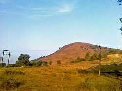
Bhilad is located in the close proximity to the mountain ranges of Sahyadri. Bhilad is surrounded by many mountains; Tramia hill, Bhilkhai hill, etc.
The Arabian Sea is about 14 km to the west, where the Darotha River creates its delta. Bhilad known for sunny weather and is lush green. Although summers are moderate and winters are pleasant, it often rains heavily at Bhilad.
Bhilad railway station
The Bhilad railway station has got its landmark importance. It is home to other villages nearby such as Sarigam, GIDC, Nargol, Fansa, Silvassa, Malav, Daheli, Dhodipada, Indiapada, Talavpada, Kandu, Sarai, Naroli and many more.
The Bhilad Railway station and also village is divided in Two Villages are Bhilad and Deheli
The Bhilad railway station is fully automated. A train originates from home called Bhilad-Baroda Exp.
Formerly Memu train originated from Bhilad but was extended up to Virar.
Hills
The hills are the ornament of the town. One of them is the Tramia, which is a watch place of Bhilad. Another hill is the Bhilkhai, which has mythological importance.
To the south of Bhilad are other hills. Tracking experience is stupendous as they are not much harder.

Jain Temple & Radhe Krishna Temple
Simandhar Swami Jain Derasar, also know at Nandigram Derasar at Nandigram village near Bhilad in Valsad district. A function was organised on Vaisakh Sudh 6th on its foundation day, 10 May 1989. Jain saints and devotees over placing ‘dhwaja’ (flag) over temple. Jain devotees from all across the state and Maharashtra were present in huge numbers to celebrate the function under the blessings of Jain saint. Place the ‘dhwaja’ upon the temple. Members of Gogalia Parivar, who happens to be the trustee of the temple.near N.H.No:8. also Radhe Krishna Temple Nearby Bhilad police station which is 38 years old temple in bhilad.
Government Health center,Bank and many more Facilities are there.
Demographics
Due to the four walls of Bhilad; Vapi(to the north), Silvassa (to the east), Sanjan-Umbergaon (to the south) and Sarigam-Fansa (to the west), Bhilad has become a favorite choice for residential purposes surrounded to all 4 sides by industrial areas. Due to low land prices, the town's jobs have become the first choice for workers.
Gallery
| Wikimedia Commons has media related to Bhilad. |
-

A view of Bodo 'Dungro' from another side.
-

A Riverside in Bhilad
-

Devotees finalizing bhilkhai hill to witness auspicious god idols