Bhargavi River
Bhargavi River flows across Odisha, India. It forms the Mahanadi–Kuakhai distributary system branching off from the Kuakhai River and draining into Chilka Lake.
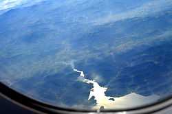
A branch of the Kuakhai River meets the Bay of Bengal after breaking up into numerous distributaries in the last 4.0 kilometres (2.5 mi) of its course. There are four main branches all branching off from the left bank: Kanchi, the East Kania, the Naya Nadi and the South Kanchi (which drains into Sar Lake). By various channels the first three are interconnected and finally join the Suna Munhi River, which flows into Bali Harchandi and ultimately drains to the Bay of Bengal via the mouth of Chilika. The South Kania gets lost in the marshes on the western shore of Chilika.
References
|
|---|
| | Rivers | |
|---|
| | Lakes | |
|---|
| | Waterfalls | |
|---|
| | Hot springs | |
|---|
| | Beaches | |
|---|
| | Dams | |
|---|
| | Bridges | |
|---|
| | Harbours/Ports/Proposed Ports | |
|---|
| | Related topics |
- Godavari basin
- Mahanadi-Brahmani-Baitarani basin
|
|---|
| | Hydrography of surrounding areas |
- Andhra Pradesh
- Chhattisgarh
- Jharkhand
- Bengal
|
|---|
|
|
|---|
| | Rivers | |
|---|
| | Dams, barrages | |
|---|
| | Geographical features | |
|---|
| | Riparian districts | |
|---|
| | Languages/ people | |
|---|
| | Coalfields | |
|---|
| | Industries | |
|---|
| | Transport |
- NH 5
- NH 6
- NH 42
- NH 78
- NH 111
- Second Mahanadi Rail Bridge
- Tatanagar-Bilaspur section and Bilaspur-Nagpur section of Howrah-Nagpur-Mumbai line
- Jharsuguda-Vizianagaram line
|
|---|
| | Related topics |
- Hydrography of Chhattisgarh
- Hydrography of Jharkhand
- Hydrography of Odisha
|
|---|
| | Other basins |
- Damodar
- Godavari
- Kosi
- Narmada
- Son
|
|---|
|