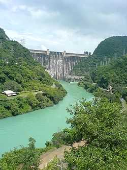
Bhakra Dam
| Bhakra Dam | |
|---|---|
 The Bhakra Dam | |
 | |
| Official name | Bhakra Dam |
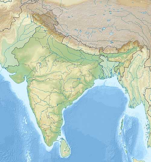
| Location | Bilaspur, Himachal Pradesh, India |
| Coordinates | 31°24′39″N 76°26′0″E / 31.41083°N 76.43333°ECoordinates: 31°24′39″N 76°26′0″E / 31.41083°N 76.43333°E |
| Construction began | 1948 |
| Opening date | 1963 |
| Construction cost | 245.28 crore INR in 1963 |
| Dam and spillways | |
| Type of dam | Concrete gravity |
| Impounds | Sutlej River |
| Height | 741 ft (226 m) |
| Length | 1,700 ft (520 m) |
| Width (crest) | 30 ft (9.1 m) |
| Width (base) | 625 ft (191 m) |
| Spillway type | Controlled, overflow |
| Reservoir | |
| Creates | Gobindsagar Reservoir |
| Total capacity | 9.340 km3 |
| Surface area | 168.35 km2 |
| Power station | |
| Commission date | 1960-1968 |
| Turbines | 5 x 10⁸ MW, 5 x 157 MW Francis-type |
| Installed capacity | 1325 MW |
Bhakra Dam is a concrete gravity dam across the Sutlej River in Bilaspur, Himachal Pradesh in northern India.
The dam, located at a gorge near the (now submerged) upstream Bhakra village in Bilaspur district of Himachal Pradesh, is India's tallest at 226 m.[1] The length of the dam (measured from the road above it) is 518.25 m and the width is 9.1 m. Its reservoir known as "Gobind Sagar" stores up to 9.34 billion cubic metres of water. The 90 km long reservoir created by the Bhakra Dam is spread over an area of 168.35 km2. In terms of quantity of water, it is the third largest reservoir in India, the first being Indira Sagar Dam in Madhya Pradesh with capacity of 12.22 billion cu m and second Nagarjunasagar Dam.
Described as "New Temple of Resurgent India" by Jawaharlal Nehru,[2] the first prime minister of India, the dam attracts tourists from all over India. Bhakra dam is 15 km from Nangal city and 20 km from Naina Devi town.
Nangal dam is another dam downstream of Bhakra dam. Sometimes both the dams together are called Bhakra-Nangal dam though they are two separate dams.
History
| Bhakra Dam bridge | |
|---|---|
| Characteristics | |
| Total length | 1700 feet |
| Width | 30 feet |
The Bhakra-Nangal multipurpose dams were among the earliest river valley development schemes undertaken by India after independence though the project had been conceived long before India became a free nation. Preliminary works commenced in 1946. Construction of the dam started in 1948, Jawahar Lal Nehru poured the first bucket of concrete into the foundations of Bhakra on 18 November 1955 [3] and the dam was completed by the end of 1963. Successive stages were completed by the early 1970s.
Initially, the construction of the dam was started by Sir Louis Dane, the Lieutenant Governor of Punjab. But the project got delayed and was restarted soon after Independence. In October 1963 at the ceremony to mark the dedication of the Bhakra–Nangal project to the nation, Prime Minister Jawaharlal Nehru said, "This dam has been built with the unrelenting toil of man for the benefit of mankind and therefore is worthy of worship. May you call it a Temple or a Gurdwara or a Mosque, it inspires our admiration and reverence". On 22 October 2013, the Government of India approved the release of a commemorative stamp to mark the 50th anniversary of the Bhakra Dam.
Features
The dam, at 741 ft (226 m), is one of the highest gravity dams in the world (compared to USA's largest Hoover Dam at 743 ft). The 166 km² Gobindsagar Reservoir, named after Guru Gobind Singh, is created by this dam which is the third largest reservoir in India the first being Indira Sagar Dam and second Nagarjunasagar Dam.[4] The river Satluj used to flow through a narrow gorge between two hills, Naina Devi ki dhar and Ramgarh ki dhar, and the site was chosen to dam the river. The large map http://www.lib.utexas.edu/maps/ams/india/nh-43-03.jpg shows the location of the original Bhakra village that was submerged in the lake formed behind the dam.
Bhakra dam was part of the larger multipurpose Bhakra Nangal Project whose aims were to prevent floods in the Sutluj-Beas river valley, to provide irrigation to adjoining states and to provide hydro-electricity. It also became a tourist spot for the tourists during later years because of it huge size and uniqueness.
Irrigation
The dam was constructed with an aim to provide irrigation to Himachal Pradesh and Punjab. Another reason behind the construction of the dam was to prevent damage due to monsoon floods. The dam provides irrigation to 10 million acres (40,000 km²) of fields in Himachal Pradesh, Punjab, Haryana, and Rajasthan. It also has five flood gates to control floods.
Water flows from Bhakra Dam to downstream Nangal Dam where the water is controlled and released into canals for irrigation.
Electricity generation
Bhakra Dam and Nangal Dam both have hydroelectric power generators, which are situated on both the sides of the dams. Nangal hydel Channel and Anandpur Sahib Channel are used for power generation and irrigation purposes.
Each power plant consists of five turbines. Two power houses with a total capacity of 1325 MW flank the dam, on either side of the river. The left power house contains 5 x 10⁸ MW Francis turbines while the right 5 x 157 MW.[5]
The power generated at Bhakra and Nangal is distributed among partner states of Himachal Pradesh, Punjab, Haryana, Rajasthan and Chandigarh.
Management
Bhakra Management Board (BMB) was constituted in 1966 for the administration, maintenance and operation of Bhakra Nangal Project from 1 October 1967. It manages the operation of both the dams. Its members are appointed by the government of India and by the states of Punjab, Haryana, Rajasthan, Himachal Pradesh, Delhi and Chandigarh. Bhakra Management Board was renamed Bhakra Beas Management Board (BBMB) on 15 May 1976 to also manage dams on river Beas. Since then the Bhakra Beas Management Board is engaged in the regulation of the supply of water and power from Bhakra Nangal Project and Beas Projects to the states of Punjab, Haryana, Rajasthan, Himachal Pradesh, Delhi and Chandigarh.
Tourism
Being the second highest dam in India after Tehri Dam, it attracts a large number of tourists who visit its reservoir and attractive location. The distance between the Ganguwal and Bhakra Dam is about 30–35 km.
See also
- Koldam Dam – being constructed upstream
- List of reservoirs and dams in India
Notes
- ↑ "Central Water Commission website".
- ↑ http://bbmb.gov.in/english/history_nangal_dam.asp accessed on 14 Nov 2009
- ↑ http://www.hindu.com/2005/11/18/stories/2005111800280900.htm accessed on 14 Dec 09, published at the link on 18 Nov 2005 (according to the page, the original story was published on 18 Nov 1955).
- ↑ "India: National Register of Large Dams 2009" (PDF). Central Water Commission. Archived (PDF) from the original on 21 July 2011. Retrieved 10 July 2011.
- ↑ "Hydroelectric Power Plants in India - Punjab". IndustCards. 23 October 2010.
External links
![]() Media related to Bhakra Dam at Wikimedia Commons
Media related to Bhakra Dam at Wikimedia Commons
- , Bhakra Beas Management Board
- Site about Bhakra Nangal Dam
| ||||||||||||||||||||||