Beverly Glen, Los Angeles
| Beverly Glen | |
|---|---|
| Neighborhood of Los Angeles | |
 Beverly Glen Location within Western Los Angeles | |
| Coordinates: 34°06′28″N 118°26′41″W / 34.10778°N 118.44472°W | |
| Country | United States |
| State | California |
| County | Los Angeles |
| City | Los Angeles |
| Time zone | PST (UTC-8) |
| • Summer (DST) | PDT (UTC-7) |
| ZIP Code | 90210 and 90077 |
| Website | http://beverlyglen.org/ |
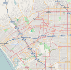
Beverly Glen is a Beverly Crest neighborhood located around Beverly Glen Boulevard north of Sunset Boulevard and south of Mulholland Drive. It is a predominantly wealthy area, with residences ranging from large gated estates to smaller one-story family homes. Stone Canyon Reservoir lies in the neighborhood.
The neighborhood of Beverly Glen is located within the ZIP codes of 90210 and 90077. Residents living in Beverly Glen access their homes primarily by use of Beverly Glen Boulevard, which is a busy thoroughfare for drivers between the Century City/Westwood area and the San Fernando Valley.
At the top of the canyon, Bel Air Ridge and Beverly Glen Park are planned developments with tennis courts and community pools built in the 1970s and '80s.[1]
Education
Beverly Glen is zoned to Los Angeles Unified School District schools.[2]
The neighborhood is jointly zoned to Warner Avenue Elementary School and Roscomare Road Elementary School.
In addition, the neighborhood is zoned to Emerson Middle School and University High School.
Police service
Los Angeles Police Department operates the West Los Angeles Community Police Station at 1663 Butler Avenue, 90025, serving the neighborhood.[3]
Parks and recreation
Briarwood Park is located on 461 Almaden Court, Los Angeles, CA 90077. This is a pocket park; it is unstaffed and open from dawn to dusk.[4]
De Neve Square Park is located on 314 Beverly Glen Blvd., Los Angeles, CA 90077. This park is a pocket park; it is unstaffed and open from dawn to dusk.
The community puts on a street fair each June and an annual garden walk and brunch.[5] In 2001, the Beverly Glen farmers market was founded.[6]
References
- ↑ Joanne Cunha (April 20, 2003), Seclusion and starry nights, for a pretty penny Los Angeles Times.
- ↑ http://www.latimes.com/classified/realestate/printedition/la-re-guide20apr20,1,5314444.story latimes.com
- ↑ http://www.lapdonline.org/west_la_community_police_station lapdonline.org
- ↑ "
- ↑ Joanne Cunha (April 20, 2003), Seclusion and starry nights, for a pretty penny Los Angeles Times.
- ↑ David Karp (March 28, 2001), Albino Pears in Beverly Glen Los Angeles Times.
External links
- Los Angeles Times neighborhood review.
- History of Beverly Glen
- About Beverly Glen, Beverly Glen Org.
 |
Sherman Oaks | Sherman Oaks | Studio City |
| |||
| |
|||||||
| Bel Air, Los Angeles | |
Benedict Canyon, Los Angeles | |||||
| |
|||||||
| Westwood, Los Angeles | Los Angeles Country Club - | West Hollywood |
| |||||||||||||||||
| |||||||||||||||||||||
Coordinates: 34°06′28″N 118°26′41″W / 34.10778°N 118.44472°W