Beulah, Colorado
| Beulah, Colorado | |
|---|---|
| Unincorporated community | |
 Beulah, Colorado Location within the state of Colorado | |
| Coordinates: 38°04′33″N 104°59′10″W / 38.07583°N 104.98611°WCoordinates: 38°04′33″N 104°59′10″W / 38.07583°N 104.98611°W | |
| Country |
|
| State |
|
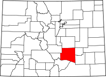
| County | Pueblo County |
| Settled | 1862[1] |
| Elevation[2] | 6,381 ft (1,945 m) |
| Time zone | MST (UTC-7) |
| • Summer (DST) | MDT (UTC-6) |
| ZIP Code | 81023[3] |
Beulah is an unincorporated community and U.S. Post Office in Pueblo County, Colorado, United States. The ZIP Code of the Beulah Post Office is 81023.[3] Beulah lies along State Highway 78 about 21 miles southwest of Pueblo, in the foothills of the Wet Mountains.
History
The town of Mace's Hole was settled in 1862.[1] The town was named for Juan Mace, a bandit who used the valley for a hideout. The Mace's Hole Post Office opened on April 23, 1873.[4] A local preacher took umbrage at the town's name and suggested the biblical name Beulah as a more wholesome alternative.[1] The name of the town was changed to Beulah on October 25, 1876.[4] The name is a reference to Isaiah 62:4;[5] it comes from the Hebrew for "married."[6]
Geography
Beulah is located at 38°04′33″N 104°59′10″W / 38.07583°N 104.98611°W (38.075798,-104.986038).
Gallery
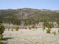
-

A picture of the town taken from the south facing mountain.
-

The local K-8 magnet school, Beulah School of Natural Sciences.
-
A local house (at the image center) on the north mountain range.
See also
- Outline of Colorado
- State of Colorado
- Colorado cities and towns
- Colorado counties
- Colorado metropolitan areas
- Front Range Urban Corridor
- South Central Colorado Urban Area
- Pueblo, CO Metropolitan Statistical Area
- Beulah Valley, Colorado
References
- ↑ 1.0 1.1 1.2 Eichler, Geo. R. (1977). Colorado Place Names. 77-089726: Johnson Publishing Company.
- ↑ "US Board on Geographic Names". United States Geological Survey. 2007-10-25. Retrieved 2008-01-31.
- ↑ 3.0 3.1 "ZIP Code Lookup" (JAVASCRIPT/HTML). United States Postal Service. Retrieved September 3, 2007.
- ↑ 4.0 4.1 Bauer, William H.; James L. Ozment; John H. Willard (1990). Colorado Post Offices 1859-1989. 90-34759: The Colorado Railroad Museum. ISBN 0-918654-42-4.
- ↑ http://www.biblegateway.com/passage/?search=Isaiah%2062:4-5&version=9;
- ↑ http://www.answers.com/topic/beulah-1
| |||||||||||||||||||||||||